Location
Latitude: |
42-02-48.0000N (42.046667) |
Longitude: |
094-47-19.3000W (-94.788694) |
Elevation: |
1203.7 feet MSL (367 m MSL) |
Magnetic Variation: |
1.3 E (as of April 2024 from WMM2020 model) |
Time Zone: |
UTC -6.0 (Standard Time) UTC -5.0 (Daylight Savings Time) |
From City: |
04 N.M. SE of Carroll, Iowa |
Found On: |
Omaha Chart |
FAA Region: |
ACE |
Contacts
Manager: |
Publicly owned: |
| DONALD MENSEN 21177 QUAIL AVE CARROLL, IA 51401 712-792-4980 |
CITY OF CARROLL 627 NORTH ADAMS CARROLL, IA 51401 712-792-1000 |
Operations
Airport Status: |
Operational |
Facility Use: |
Public |
Type: |
Airport |
Activation Date: |
04/1945 |
Control tower: |
No |
Attendance (Months/Days/Hours): |
Months/Days/Hours ALL/ALL/0800-DUSK |
Boundary ARTCC: |
ZMP (Minneapolis) |
Responsible ARTCC: |
ZMP (Minneapolis) |
Lighting Schedule: |
SEE RMK |
Segmented Circle Indicator: |
No |
Traffic Pattern Altitude (MSL): |
2204 feet (672 m) |
NOTAMs Facility: |
CIN |
NOTAM-D Service: |
Yes |
International Airport of Entry: |
No |
Customs Landing Rights: |
No |
Military Landing Rights: |
Yes |
Civil/Military Joint Use: |
No |
Based Aircraft
| Single Engine: | 12 |
| Multi Engine: | 2 |
| Jet Engine: | 1 |
Annual Operations (as of 05/12/2021)
| Total Operations: | 4500 | |
| Air Taxi: | 375 | 8.3% |
| GA Local: | 2285 | 50.8% |
| GA Itinerant: | 1825 | 40.6% |
| Military Aircraft: | 15 | 0.3% |
Communications
| CTAF: | 122.800 |
| Unicom: | 122.800 |
| AWOS-3: | 118.025 (712-792-2306) |
- APCH/DEP SVC PRVDD BY MINNEAPOLIS ARTCC (ZMP) ON FREQS 134.0/288.3 (FORT DODGE RCAG).
Fixed Based Operators (FBOs) & Fuel
(Click on a business for detail)
Please help us keep this information up to date. This is a FREE SERVICE just like everything else on Airport Guide! If you see that a business needs to be added, modified, or deleted please fill out our Update Form.
To add, modify, or delete a business click here.
Please help us keep this information up to date. This is a FREE SERVICE just like everything else on Airport Guide! If you see that a business needs to be added, modified, or deleted please fill out our Update Form.
Area Code: 712 |
| Business Name | Frequency | Phone | Fuel Grade |
|---|---|---|---|
| Carroll Aviation, Inc.
Update FBO info |
Unicom 122.8 | 792-4908 | 100LL, Jet A, MOGAS |
Flight Service Stations
| Primary | Alternate | |
| FSS on Field: | N | |
| FSS Name (ID): | Fort Dodge(FOD) | |
| Frequency: | ||
| Toll Free Phone: | 1-800-WX-BRIEF |
Instrument Procedures / Charts
FAA Terminal Procedures valid from 0901Z 03/21/24 to 0901Z 04/18/24.
There are various types of charts available for an airport. They are listed in the Page Type column. Here is a legend for those types:
APD - Airport Diagram
DP - Departure Procedure Charts
HOT - Hot Spots
IAP - Instrument Approach Procedure Charts
MIN - Minimums
STAR - Standard Terminal Arrival Charts
| Page Type | Page Name | Volume | Action Since Last Cycle |
|---|---|---|---|
| IAP | RNAV (GPS) RWY 13 | NC-3 | |
| IAP | RNAV (GPS) RWY 31 | NC-3 | |
| MIN | ALTERNATE MINIMUMS | NC-3 | |
| MIN | TAKEOFF MINIMUMS | NC-3 |
Terminal Procedures are only available for airports in several countries with more being added all the time. If you are looking for a specific country's charts, please send an email to support(at)airportguide.com stating the country name. This will be used to prioritize the implementation.
Navigation Aids (Navaids) near CIN
| Dist (NM) | ID | Morse Code | Name | Type | Freq | True Hdg | Mag Hdg |
|---|---|---|---|---|---|---|---|
| 20.0 | EFW | . . . _ . . _ _ | Jefferson | NDB | 391 | 95 | 94 |
| 21.8 | SKI | . . . _ . _ . . | Sac City | NDB | 356 | 336 | 335 |
| 22.1 | ADU | . _ _ . . . . _ | Audubon | NDB | 266 | 194 | 193 |
| 26.6 | DNS | _ . . _ . . . . | Denison | NDB | 350 | 262 | 261 |
| 35.3 | FO | . . _ . _ _ _ | Barro | NDB | 341 | 37 | 36 |
| 37.4 | HNR | . . . . _ . . _ . | Harlan | NDB | 272 | 221 | 220 |
| 38.9 | SLB | . . . . _ . . _ . . . | Storm Lake | NDB | 434 | 328 | 327 |
| 40.2 | AIO | . _ . . _ _ _ | Atlantic | NDB | 365 | 196 | 195 |
| 40.3 | FOD | . . _ . _ _ _ _ . . | Fort Dodge | TACAN | 113.50 | 32 | 31 |
| 42.4 | POH | . _ _ . _ _ _ . . . . | Pocahontas | NDB | 428 | 8 | 7 |
| 45.5 | MEY | _ _ . _ . _ _ | Mapleton | NDB | 335 | 280 | 278 |
| 47.2 | EBS | . _ . . . . . . | Webster City | NDB | 323 | 59 | 58 |
| 51.1 | EE | . . | Merle | NDB | 362 | 99 | 98 |
| 59.1 | DSM | _ . . . . . _ _ | Des Moines | VOT | 109.20 | 120 | 119 |
| 61.9 | CAV | _ . _ . . _ . . . _ | Clarion | NDB | 387 | 47 | 46 |
| 62.8 | DSM | _ . . . . . _ _ | Des Moines | VORTAC | 117.50 | 125 | 124 |
| 63.0 | CRZ | _ . _ . . _ . _ _ . . | Corning | NDB | 278 | 178 | 177 |
| 63.3 | EGQ | . _ _ . _ _ . _ | Emmetsburg | NDB | 410 | 3 | 2 |
| 64.4 | TQE | _ _ _ . _ . | Tekamah | VOR | 108.40 | 254 | 252 |
| 65.3 | RDK | . _ . _ . . _ . _ | Red Oak | NDB | 230 | 198 | 197 |
Nearby Airports with Fuel
Notices to Airmen (NOTAMS)
Remarks
| A11 | NORMAN HUTCHESON CHMN ARPT CMSN, PHONE 792-2621. |
| A110-1 | RY 31 IS CALM WIND RY. |
| A110-2 | FOR CD CTC MINNEAPOLIS ARTCC AT 651-463-5588. |
| A17 | FOR SVC AFTER HOURS CALL 712-792-4980. |
| A57-13 | APCH SLOPE 50:1 FROM DSPLCD THLD. |
| A81-APT | DUSK-DAWN. MIRL RYS 13/31 & 03/21 PRESET ON LOW INTST; TO INCR INTST & ACTVT PAPI RYS 13/31 & 03/21 AND REIL RYS 13/31 & 03/21 - CTAF. |
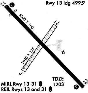
Runways
Runway Summary
| Runways: | 03/21 13/31 |
| Longest Runway: | 13/31 is 5506 ft (1678 m) long |
| Runways with an Instrument Approach: |
CIN Airport Runway Details
| Runway 03/21 | 3301 ft x 60 ft (1006 m x 18 m) | |
| Runway Length Source: | 3RD PARTY SURVEY as of 06/17/2010 | |
| Surface: | Concrete - Good condition - No special surface treatment | |
| Runway Pavement Class: | 6 /R/D/W/T | |
| Runway Edge Lights: | Medium Intensity | |
Runway 03 |
Runway 21 |
|
Elevation: |
1201.7 | 1200.5 |
Latitude: |
42-02-37.0358N | 42-03-05.2916N |
Longitude: |
094-47-30.2227W | 094-47-08.3873W |
|
Runway True Alignment: |
030 | 210 |
Glide Path Angle: |
3.0 degrees | 3.0 degrees |
Traffic Pattern: |
Left | Left |
Runway Markings Type: |
Basic | Basic |
Runway Markings Condition: |
Good | Good |
Object at End: |
ROAD | ROAD |
Object Height: |
14 | 24 |
Distance from End: |
480 | 700 |
Object Centerline Offset: |
140 ft. right of centerline | 140 ft. left of centerline |
Visual Glide Slope Indicators: |
2-Light PAPI On Left Side Of Runway | 2-Light PAPI On Left Side Of Runway |
REIL: |
Yes | Yes |
Threshold Crossing Height: |
33 | 33 |
| Runway 13/31 | 5506 ft x 100 ft (1678 m x 30 m) | |
| Runway Length Source: | 3RD PARTY SURVEY as of 06/17/2010 | |
| Surface: | Concrete - Good condition - No special surface treatment | |
| Runway Pavement Class: | 7 /R/B/W/T | |
| Runway Edge Lights: | Medium Intensity | |
Runway Weight Bearing Capacity (in thousands of pounds) |
||
| Single Wheel Landing Gear: | 30.0 | |
Runway 13 |
Runway 31 |
|
Elevation: |
1203.7 | 1202.9 |
Latitude: |
42-03-05.9278N | 42-02-26.3834N |
Longitude: |
094-47-44.3012W | 094-46-54.2101W |
|
Runway True Alignment: |
137 | 317 |
Glide Path Angle: |
3.0 degrees | 3.0 degrees |
Traffic Pattern: |
Left | Left |
Runway Markings Type: |
Nonprecision Instrument | Nonprecision Instrument |
Runway Markings Condition: |
Good | Good |
Object at End: |
RR | |
Object Height: |
33 | |
Distance from End: |
1329 | |
Object Centerline Offset: |
140 ft. right of centerline | 140 ft. left of centerline |
Visual Glide Slope Indicators: |
2-Light PAPI On Left Side Of Runway | 2-Light PAPI On Left Side Of Runway |
REIL: |
Yes | Yes |
Threshold Crossing Height: |
23 | 26 |
Threshold Elevation: |
1203.1 | |
Displaced Threshold: |
506 | |
Threshold Latitude: |
42-03-02.2951N | |
Threshold Longitude: |
094-47-39.6979W |
Services
Airframe Repair: |
None |
Powerplant Repair: |
None |
Bottled Oxygen: |
None |
Bulk Oxygen: |
None |
Fuel Available: |
100LL, Jet A |
Landing Fees: |
No |
Parking: |
Hangars and tiedowns available |
Maps & Diagrams
CIN Sectional
Flight Planning
at skyvector.com
at skyvector.com