
Location
Latitude: |
43-29-21.8362S (-43.489399) |
Longitude: |
172-31-55.1917E (172.531998) |
Elevation: |
123 feet MSL (37 m MSL) |
Magnetic Variation: |
24.5 E (as of April 2024 from WMM2020 model) |
Time Zone: |
UTC +12.0 (Standard Time) UTC +13.0 (Daylight Savings Time) |
Contacts
Manager: |
: |
Operations
Airport Status: |
Operational |
Facility Use: |
Public |
Type: |
Airport |
Traffic Pattern Altitude (MSL): |
1123 feet (342 m) |
Based Aircraft
Annual Operations (as of )
Communications
| TWR: | 118.4 |
| Delivery: | 128.2 |
| GND: | 121.9 |
| APP: | 124.1 |
| ATIS: | 127.2 |
| Control: | 120.9 |
| AMC OPS: | 122.5 |
Fixed Based Operators (FBOs) & Fuel
(Click on a business for detail)
Please help us keep this information up to date. This is a FREE SERVICE just like everything else on Airport Guide! If you see that a business needs to be added, modified, or deleted please fill out our Update Form.
To add, modify, or delete a business click here.
Please help us keep this information up to date. This is a FREE SERVICE just like everything else on Airport Guide! If you see that a business needs to be added, modified, or deleted please fill out our Update Form.
| Business Name | Frequency | Phone | Fuel Grade |
|---|
Flight Service Stations
| Primary | Alternate | |
| FSS on Field: | ||
| FSS Name (ID): | ||
| Frequency: | ||
| Toll Free Phone: |
Instrument Procedures / Charts
Terminal Procedures are only available for airports in several countries with more being added all the time. If you are looking for a specific country's charts, please send an email to support(at)airportguide.com stating the country name. This will be used to prioritize the implementation.
Navigation Aids (Navaids) near CHC
| Dist (NM) | ID | Morse Code | Name | Type | Freq | True Hdg | Mag Hdg |
|---|---|---|---|---|---|---|---|
| 1.2 | CH | Christchurch | VOR-DME | 115.30 | 219 | 195 | |
| 8.4 | YW | Eyrewell | VOR-DME | 116.60 | 310 | 286 | |
| 9.4 | BU | Burnham | NDB | 374 | 220 | 195 | |
| 11.5 | OD | Woodend | NDB | 262 | 39 | 15 | |
| 40.1 | AS | Ashburton | NDB | 254 | 231 | 206 | |
| 74.9 | TU | Timaru | NDB-DME | 366 | 228 | 203 | |
| 82.0 | KI | Kaikoura | NDB | 350 | 38 | 14 | |
| 82.7 | HK | Hokitika | NDB-DME | 310 | 302 | 278 |
Nearby Airports with Fuel
| Dist (NM) | Name (Airport IDs) | True Hdg | Mag Hdg | Fuel Grade |
|---|
Notices to Airmen (NOTAMS)
Remarks
No remarks for this landing facility
Runways
Runway Summary
| Runways: | 01/19 02/20 11/29 |
| Longest Runway: | 02/20 is 10787 ft (3288 m) long |
| Runways with an Instrument Approach: |
CHC Airport Runway Details
| Runway 01/19 | 1690 ft x 229 ft (515 m x 70 m) | |
Runway 01 |
Runway 19 |
|
Latitude: |
-43.4865989685 | -43.4827003479 |
Longitude: |
172.53100585937 | 172.53500366210 |
|
Runway True Alignment: |
37.7 | 217.7 |
Glide Path Angle: |
0.0 degrees | 0.0 degrees |
| Runway 02/20 | 10787 ft x 148 ft (3288 m x 45 m) | |
| Runway Edge Lights: | Yes Intensity | |
Runway 02 |
Runway 20 |
|
Elevation: |
123 | 93 |
Latitude: |
-43.4976005554 | -43.4749984741 |
Longitude: |
172.52200317382 | 172.54800415039 |
|
Runway True Alignment: |
41 | 221 |
Glide Path Angle: |
0.0 degrees | 0.0 degrees |
REIL: |
Yes | Yes |
Threshold Elevation: |
123 | 93 |
| Runway 11/29 | 5587 ft x 148 ft (1703 m x 45 m) | |
| Runway Edge Lights: | Yes Intensity | |
Runway 11 |
Runway 29 |
|
Elevation: |
115 | 95 |
Latitude: |
-43.4846000671 | -43.4947013854 |
Longitude: |
172.52499389648 | 172.54100036621 |
|
Runway True Alignment: |
131 | 311 |
Glide Path Angle: |
0.0 degrees | 0.0 degrees |
REIL: |
Yes | Yes |
Threshold Elevation: |
115 | 95 |
Services
Maps & Diagrams
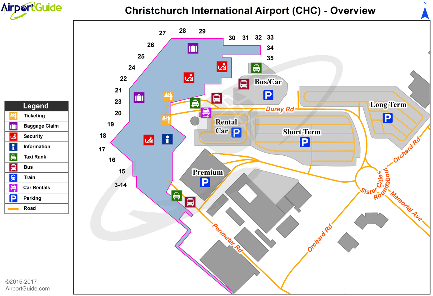
CHC Sectional
Flight Planning
at skyvector.com
at skyvector.com
