
Location
Latitude: |
30-07-18.842N (30.121901) |
Longitude: |
031-24-20.1585E (31.4056) |
Elevation: |
382 feet MSL (116 m MSL) |
Magnetic Variation: |
4.9 E (as of April 2024 from WMM2020 model) |
Time Zone: |
UTC +2.0 (Standard Time) UTC +3.0 (Daylight Savings Time) |
Contacts
Manager: |
: |
Operations
Airport Status: |
Operational |
Facility Use: |
Public |
Type: |
Airport |
Traffic Pattern Altitude (MSL): |
1382 feet (421 m) |
Based Aircraft
Annual Operations (as of )
Communications
| cairo radio: | 11.3 |
| TWR: | 118.1 |
| GND: | 121.9 |
| APP: | 119.05 |
| ATIS: | 122.6 |
| VOLMET: | 126.2 |
| PREFLIGHT: | 120.1 |
| Volmet: | 124.6 |
Fixed Based Operators (FBOs) & Fuel
(Click on a business for detail)
Please help us keep this information up to date. This is a FREE SERVICE just like everything else on Airport Guide! If you see that a business needs to be added, modified, or deleted please fill out our Update Form.
To add, modify, or delete a business click here.
Please help us keep this information up to date. This is a FREE SERVICE just like everything else on Airport Guide! If you see that a business needs to be added, modified, or deleted please fill out our Update Form.
| Business Name | Frequency | Phone | Fuel Grade |
|---|
Flight Service Stations
| Primary | Alternate | |
| FSS on Field: | ||
| FSS Name (ID): | ||
| Frequency: | ||
| Toll Free Phone: |
Instrument Procedures / Charts
Terminal Procedures are only available for airports in several countries with more being added all the time. If you are looking for a specific country's charts, please send an email to support(at)airportguide.com stating the country name. This will be used to prioritize the implementation.
Navigation Aids (Navaids) near CAI
| Dist (NM) | ID | Morse Code | Name | Type | Freq | True Hdg | Mag Hdg |
|---|---|---|---|---|---|---|---|
| 2.0 | CVO | Cairo | VOR-DME | 115.20 | 206 | 201 | |
| 2.0 | CAI | Cairo | VOR-DME | 112.50 | 27 | 22 | |
| 2.9 | ALI | Cairo | NDB | 310 | 338 | 333 | |
| 3.1 | MXR | Almaza | TACAN | 116.30 | 234 | 229 | |
| 3.7 | A | Almaza | NDB | 490 | 219 | 214 | |
| 8.3 | MKT | Cairo | NDB | 317 | 234 | 229 | |
| 25.6 | BLA | Cairo West | TACAN | 116.70 | 269 | 264 | |
| 35.2 | OCT | October | NDB | 340 | 238 | 233 | |
| 68.3 | FYM | Fayoum | VOR-DME | 117.30 | 230 | 225 | |
| 81.6 | PSD | Port Said | VOR-DME | 112.70 | 31 | 26 | |
| 85.7 | BLT | Baltim | VOR-DME | 116.90 | 350 | 345 | |
| 97.7 | DJ | Borg El Arab | NDB | 563 | 298 | 293 | |
| 98.6 | NOZ | Alexandria | VOR-DME | 115.90 | 310 | 305 | |
| 98.8 | AXD | Alexandria | NDB | 403 | 311 | 306 | |
| 99.1 | D | Inner Beacon | NDB | 273 | 298 | 293 |
Nearby Airports with Fuel
| Dist (NM) | Name (Airport IDs) | True Hdg | Mag Hdg | Fuel Grade |
|---|
Notices to Airmen (NOTAMS)
Remarks
No remarks for this landing facility
Runways
Runway Summary
| Runways: | 05C/23C 05L/23R 05R/23L |
| Longest Runway: | 05R/23L is 13124 ft (4000 m) long |
| Runways with an Instrument Approach: |
CAI Airport Runway Details
| Runway 05C/23C | 13120 ft x 197 ft (3999 m x 60 m) | |
| Runway Edge Lights: | Yes Intensity | |
Runway 05C |
Runway 23C |
|
Elevation: |
382 | 375 |
Latitude: |
30.099701 | 30.123301 |
Longitude: |
31.398199 | 31.4296 |
|
Runway True Alignment: |
45 | 225 |
Glide Path Angle: |
0.0 degrees | 0.0 degrees |
REIL: |
Yes | Yes |
Threshold Elevation: |
382 | 375 |
| Runway 05L/23R | 10830 ft x 197 ft (3301 m x 60 m) | |
| Runway Edge Lights: | Yes Intensity | |
Runway 05L |
Runway 23R |
|
Elevation: |
190 | 199 |
Latitude: |
30.11969947814 | 30.13909912109 |
Longitude: |
31.380199432373 | 31.406299591064 |
|
Runway True Alignment: |
49.4 | 229.4 |
Glide Path Angle: |
0.0 degrees | 0.0 degrees |
REIL: |
Yes | Yes |
Threshold Elevation: |
190 | 199 |
| Runway 05R/23L | 13124 ft x 197 ft (4000 m x 60 m) | |
| Runway Edge Lights: | Yes Intensity | |
Runway 05R |
Runway 23L |
|
Elevation: |
382 | 375 |
Latitude: |
30.09716606140 | 30.12066650390 |
Longitude: |
31.419000625610 | 31.450500488281 |
|
Runway True Alignment: |
49.2 | 229.2 |
Glide Path Angle: |
0.0 degrees | 0.0 degrees |
REIL: |
Yes | Yes |
Threshold Elevation: |
382 | 375 |
Services
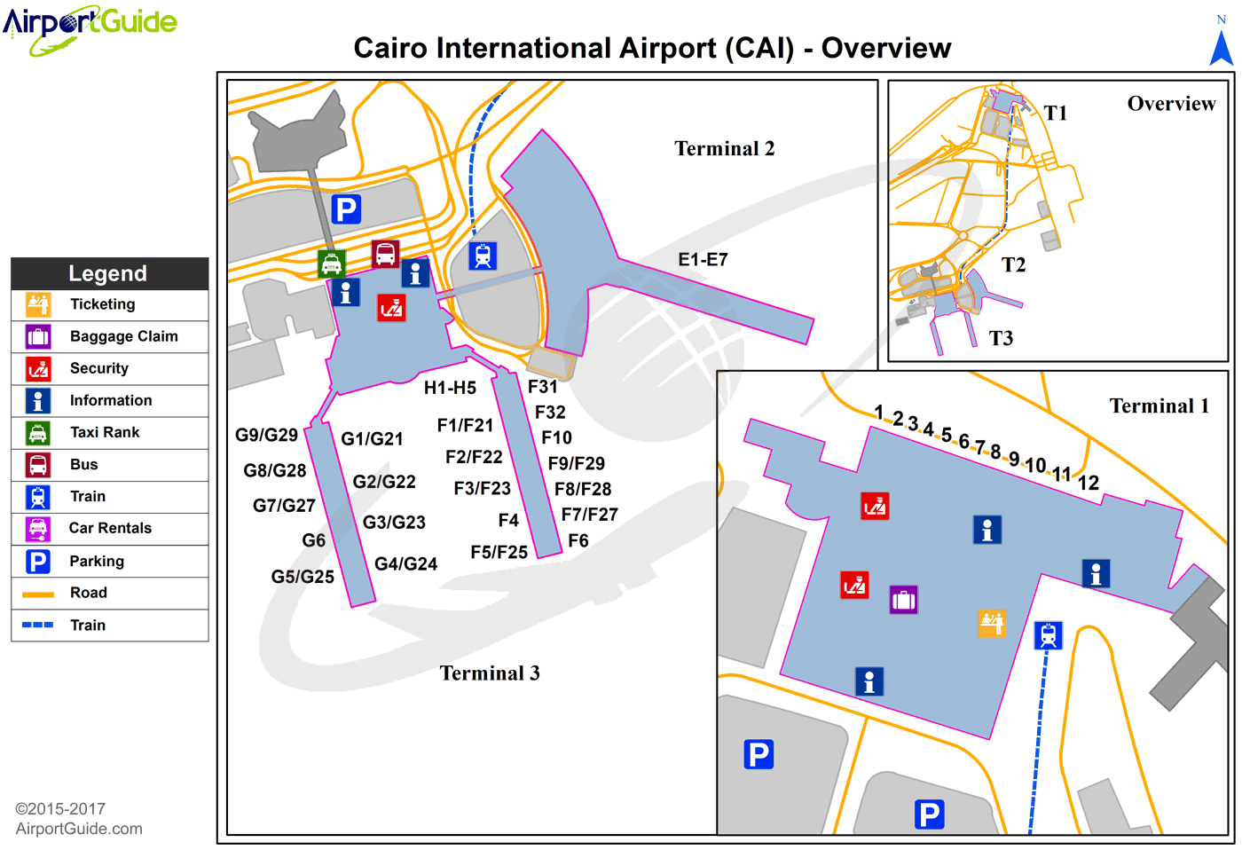
Maps & Diagrams
CAI Sectional
Flight Planning
at skyvector.com
at skyvector.com
