Location
Latitude: |
34-37-18.1510N (34.621709) |
Longitude: |
079-44-03.6940W (-79.734359) |
Elevation: |
146.8 feet MSL (45 m MSL) |
Magnetic Variation: |
8.6 W (as of April 2024 from WMM2020 model) |
Time Zone: |
UTC -5.0 (Standard Time) UTC -4.0 (Daylight Savings Time) |
From City: |
03 N.M. W of Bennettsville, South Carolina |
Found On: |
Charlotte Chart |
FAA Region: |
ASO |
Contacts
Manager: |
Publicly owned: |
| MR. BARRY AVENT P.O. BOX 535, 1231 AIRPORT ROAD BENNETTSVILLE, SC 29512 (843) 479-4797 |
MARLBORO COUNTY PO BOX 419 BENNETTSVILLE, SC 29512 843-479-5647 |
Operations
Airport Status: |
Operational |
Facility Use: |
Public |
Type: |
Airport |
Control tower: |
No |
Attendance (Months/Days/Hours): |
Months/Days/Hours ALL/MON-SAT/0800-1700 |
Boundary ARTCC: |
ZJX (Jacksonville) |
Responsible ARTCC: |
ZJX (Jacksonville) |
Lighting Schedule: |
SS-SR |
Segmented Circle Indicator: |
Yes |
Traffic Pattern Altitude (MSL): |
1147 feet (350 m) |
NOTAMs Facility: |
AND |
NOTAM-D Service: |
Yes |
International Airport of Entry: |
No |
Customs Landing Rights: |
No |
Military Landing Rights: |
Yes |
Civil/Military Joint Use: |
No |
Based Aircraft
| Single Engine: | 11 |
Annual Operations (as of 04/04/2018)
| Total Operations: | 3760 | |
| Air Taxi: | 60 | 1.6% |
| GA Local: | 1200 | 31.9% |
| GA Itinerant: | 2500 | 66.5% |
Communications
| CTAF: | 122.800 |
| Unicom: | 122.800 |
| Approach: | FLORENCE 118.6 118.6 JAX ARTCC |
| Departure: | FLORENCE 118.6 118.6 JAX ARTCC |
| AWOS-3PT: | 123.825 (843-479-5817) |
- APCH/DEP SVC PRVDD BY JACKSONVILLE ATRCC ON FREQS 133.45/306.3 (FLORENCE RCAG) WHEN FLORENCE APCH CTL CLSD.
Fixed Based Operators (FBOs) & Fuel
(Click on a business for detail)
Please help us keep this information up to date. This is a FREE SERVICE just like everything else on Airport Guide! If you see that a business needs to be added, modified, or deleted please fill out our Update Form.
To add, modify, or delete a business click here.
Please help us keep this information up to date. This is a FREE SERVICE just like everything else on Airport Guide! If you see that a business needs to be added, modified, or deleted please fill out our Update Form.
Area Code: 803 |
| Business Name | Frequency | Phone | Fuel Grade |
|---|---|---|---|
| Marlboro County Airport
Update FBO info |
479-5647 | 100LL, Jet A |
Flight Service Stations
| Primary | Alternate | |
| FSS on Field: | N | |
| FSS Name (ID): | Anderson(AND) | |
| Frequency: | ||
| Toll Free Phone: | 1-800-WX-BRIEF |
Instrument Procedures / Charts
FAA Terminal Procedures valid from 0901Z 03/21/24 to 0901Z 04/18/24.
There are various types of charts available for an airport. They are listed in the Page Type column. Here is a legend for those types:
APD - Airport Diagram
DP - Departure Procedure Charts
HOT - Hot Spots
IAP - Instrument Approach Procedure Charts
MIN - Minimums
STAR - Standard Terminal Arrival Charts
| Page Type | Page Name | Volume | Action Since Last Cycle |
|---|---|---|---|
| IAP | RNAV (GPS) RWY 07 | SE-2 | |
| IAP | RNAV (GPS) RWY 25 | SE-2 | |
| MIN | ALTERNATE MINIMUMS | SE-2 | |
| MIN | TAKEOFF MINIMUMS | SE-2 |
Terminal Procedures are only available for airports in several countries with more being added all the time. If you are looking for a specific country's charts, please send an email to support(at)airportguide.com stating the country name. This will be used to prioritize the implementation.
Navigation Aids (Navaids) near BTN
| Dist (NM) | ID | Morse Code | Name | Type | Freq | True Hdg | Mag Hdg |
|---|---|---|---|---|---|---|---|
| 0.1 | BES | _ . . . . . . . | Bennettsville | NDB | 230 | 147 | 156 |
| 9.7 | CQW | _ . _ . _ _ . _ . _ _ | Cheraw | NDB | 409 | 318 | 327 |
| 13.1 | UDG | . . _ _ . . _ _ . | Darlington | NDB | 245 | 215 | 224 |
| 15.8 | ME | _ _ . | Maxtn | NDB | 257 | 64 | 73 |
| 20.8 | DLC | _ . . . _ . . _ . _ . | Dillon | NDB | 274 | 119 | 128 |
| 23.0 | HVS | . . . . . . . _ . . . | Hartsville | NDB | 341 | 235 | 243 |
| 23.6 | FLO | . . _ . . _ . . _ _ _ | Florence | VORTAC | 115.20 | 170 | 179 |
| 26.7 | CTF | _ . _ . _ . . _ . | Chesterfield | VOR-DME | 114.55 | 273 | 281 |
| 27.3 | HFF | . . . . . . _ . . . _ . | Mackall | NDB | 278 | 26 | 35 |
| 27.5 | FL | . . _ . . _ . . | Alcot | NDB | 335 | 192 | 201 |
| 29.8 | JB | . _ _ _ _ . . . | Jigel | NDB | 384 | 98 | 107 |
| 30.7 | PYG | . _ _ . _ . _ _ _ _ . | Pageland | NDB | 270 | 284 | 292 |
| 32.8 | MAO | _ _ . _ _ _ _ | Marion | NDB | 388 | 142 | 151 |
| 33.3 | RSY | . _ . . . . _ . _ _ | Robeson | NDB | 359 | 90 | 99 |
| 33.5 | LBT | . _ . . _ . . . _ | Lumberton | VOR | 110.00 | 90 | 99 |
| 36.3 | SDZ | . . . _ . . _ _ . . | Sandhills | VORTAC | 111.80 | 11 | 20 |
| 46.0 | CFY | _ . _ . . . _ . _ . _ _ | Evans | NDB | 420 | 181 | 190 |
| 47.6 | FAY | . . _ . . _ _ . _ _ | Fayetteville | VOR-DME | 114.85 | 62 | 71 |
| 48.1 | POB | . _ _ . _ _ _ _ . . . | Pope | TACAN | 113.80 | 46 | 55 |
| 48.9 | SMS | . . . _ _ . . . | Sumter | NDB | 252 | 219 | 227 |
Nearby Airports with Fuel
Notices to Airmen (NOTAMS)
Remarks
| A110-1 | FOR FBO MGR BARRY AVENT CALL (843)479-4797. |
| A110-2 | FOR CD CTC FLORENCE APCH AT 843-665-0632, WHEN APCH CLSD CTC JACKSONVILLE ARTCC AT 904-845-1592. |
| A14 | COUNTY ADMINISTRATOR. |
| A17 | FOR SVC SUN CALL FBO 843-454-2303. |
| A70-FUEL-10 | 0LL FOR FUEL AFTER HRS CALL 843-862-4359. |
| E111 | RWY 16/34 LIMITED TO OPERATIONS IN VFR WX CONDS. |
Runways
Runway Summary
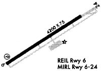
| Runways: | 07/25 |
| Longest Runway: | 07/25 is 5003 ft (1525 m) long |
| Runways with an Instrument Approach: |
BTN Airport Runway Details
| Runway 07/25 | 5003 ft x 74 ft (1525 m x 23 m) | |
| Runway Length Source: | 3RD PARTY SURVEY as of 08/15/2008 | |
| Surface: | Asphalt - Good condition - No special surface treatment | |
| Runway Edge Lights: | Medium Intensity | |
Runway Weight Bearing Capacity (in thousands of pounds) |
||
| Single Wheel Landing Gear: | 28.0 | |
| Dual Wheel Landing Gear: | 43.0 | |
| Dual Tandem Wheel Landing Gear: | 70.0 | |
Runway 07 |
Runway 25 |
|
Elevation: |
138.0 | 146.8 |
Latitude: |
34-37-04.8476N | 34-37-31.4356N |
Longitude: |
079-44-28.9331W | 079-43-38.4507W |
|
Runway True Alignment: |
058 | 238 |
Glide Path Angle: |
3.0 degrees | 3.0 degrees |
Traffic Pattern: |
Left | Left |
Runway Markings Type: |
Nonprecision Instrument | Nonprecision Instrument |
Runway Markings Condition: |
Good | Good |
Object at End: |
TREE | TREE |
Object Height: |
79 | 84 |
Distance from End: |
2299 | 2537 |
Object Centerline Offset: |
359 ft. left of centerline | 254 ft. left of centerline |
Visual Glide Slope Indicators: |
2-Light PAPI On Left Side Of Runway | 2-Light PAPI On Left Side Of Runway |
REIL: |
Yes | Yes |
Threshold Crossing Height: |
45 | 40 |
Services
Airframe Repair: |
Major |
Powerplant Repair: |
Major |
Fuel Available: |
100LL |
Parking: |
Tiedowns available |
Maps & Diagrams
BTN Sectional
Flight Planning
at skyvector.com
at skyvector.com