
Location
Latitude: |
19-05-19.3176N (19.088699) |
Longitude: |
072-52-04.4293E (72.867897) |
Elevation: |
39 feet MSL (12 m MSL) |
Magnetic Variation: |
0.1 W (as of April 2024 from WMM2020 model) |
Time Zone: |
UTC +5.5 (Standard Time) UTC +5.5 (Daylight Savings Time) |
Contacts
Manager: |
: |
Operations
Airport Status: |
Operational |
Facility Use: |
Public |
Type: |
Airport |
Traffic Pattern Altitude (MSL): |
1039 feet (317 m) |
Based Aircraft
Annual Operations (as of )
Communications
| MUMBAI RDO: | 1008.4 |
| MUMBAI TWR: | 118.1 |
| MUMBAI CLR DELIVERY: | 121.85 |
| MUMBAI GND: | 121.9 |
| MUMBAI APP: | 127.9 |
| MUMBAI ATIS: | 126.4 |
| MUMBAI: | 120.5 |
| RDR: | 119.3 |
Fixed Based Operators (FBOs) & Fuel
(Click on a business for detail)
Please help us keep this information up to date. This is a FREE SERVICE just like everything else on Airport Guide! If you see that a business needs to be added, modified, or deleted please fill out our Update Form.
To add, modify, or delete a business click here.
Please help us keep this information up to date. This is a FREE SERVICE just like everything else on Airport Guide! If you see that a business needs to be added, modified, or deleted please fill out our Update Form.
| Business Name | Frequency | Phone | Fuel Grade |
|---|
Flight Service Stations
| Primary | Alternate | |
| FSS on Field: | ||
| FSS Name (ID): | ||
| Frequency: | ||
| Toll Free Phone: |
Instrument Procedures / Charts
Terminal Procedures are only available for airports in several countries with more being added all the time. If you are looking for a specific country's charts, please send an email to support(at)airportguide.com stating the country name. This will be used to prioritize the implementation.
Navigation Aids (Navaids) near BOM
Nearby Airports with Fuel
| Dist (NM) | Name (Airport IDs) | True Hdg | Mag Hdg | Fuel Grade |
|---|
Notices to Airmen (NOTAMS)
Remarks
No remarks for this landing facility
Runways
Runway Summary
| Runways: | 09/27 14/32 |
| Longest Runway: | 09/27 is 11312 ft (3448 m) long |
| Runways with an Instrument Approach: |
BOM Airport Runway Details
| Runway 09/27 | 11312 ft x 197 ft (3448 m x 60 m) | |
| Runway Edge Lights: | Yes Intensity | |
Runway 09 |
Runway 27 |
|
Elevation: |
15 | 22 |
Latitude: |
19.08839988708 | 19.08889961242 |
Longitude: |
72.847999572753 | 72.881103515625 |
|
Runway True Alignment: |
89.2 | 269.2 |
Glide Path Angle: |
0.0 degrees | 0.0 degrees |
REIL: |
Yes | Yes |
Threshold Elevation: |
15 | 22 |
Displaced Threshold: |
465 | 1581 |
| Runway 14/32 | 9419 ft x 148 ft (2871 m x 45 m) | |
| Runway Edge Lights: | Yes Intensity | |
Runway 14 |
Runway 32 |
|
Elevation: |
37 | 26 |
Latitude: |
19.09849929809 | 19.08009910583 |
Longitude: |
72.857299804687 | 72.877197265625 |
|
Runway True Alignment: |
134.2 | 314.2 |
Glide Path Angle: |
0.0 degrees | 0.0 degrees |
REIL: |
Yes | Yes |
Threshold Elevation: |
37 | 26 |
Displaced Threshold: |
1238 | 853 |
Services
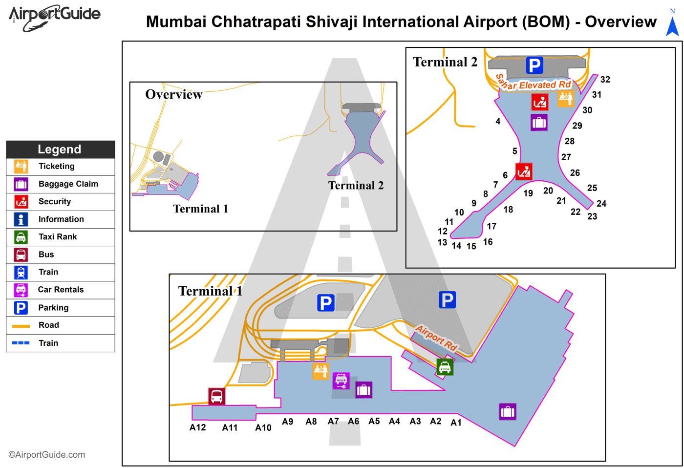
Maps & Diagrams
BOM Sectional
Flight Planning
at skyvector.com
at skyvector.com
