Location
Latitude: |
61-32-04.8590N (61.534683) |
Longitude: |
149-48-45.1740W (-149.812548) |
Elevation: |
162.4 feet MSL (49 m MSL) |
Magnetic Variation: |
14.8 E (as of April 2024 from WMM2020 model) |
Time Zone: |
UTC -9.0 (Standard Time) UTC -8.0 (Daylight Savings Time) |
From City: |
01 N.M. SE of Big Lake, Alaska |
Found On: |
Anchorage Chart |
FAA Region: |
AAL |
Contacts
Manager: |
Publicly owned: |
| KYLER HYLTON 289 INNER SPRING LOOP, DOT&PF CENTRAL REGION PALMER, AK 99645 907-745-2159 |
ALASKA DOT&PF CENTRAL REGION PO BOX 196900 ANCHORAGE, AK 99519-6900 907-269-0770 |
Operations
Airport Status: |
Operational |
Facility Use: |
Public |
Type: |
Airport |
Activation Date: |
05/1951 |
Control tower: |
No |
Attendance (Months/Days/Hours): |
Months/Days/Hours Unattended |
Boundary ARTCC: |
ZAN (Anchorage) |
Responsible ARTCC: |
ZAN (Anchorage) |
Lighting Schedule: |
SEE RMK |
Segmented Circle Indicator: |
Yes |
Traffic Pattern Altitude (MSL): |
1162 feet (354 m) |
NOTAMs Facility: |
ENA |
NOTAM-D Service: |
Yes |
Based Aircraft
| Single Engine: | 66 |
| Multi Engine: | 2 |
| GA Helicopters: | 2 |
Annual Operations (as of 12/31/2019)
| Total Operations: | 9500 | |
| GA Local: | 1500 | 15.8% |
| GA Itinerant: | 8000 | 84.2% |
Communications
| CTAF: | 122.800 |
| Approach: | ANCHORAGE 118.6 118.6 |
| Departure: | ANCHORAGE 118.6 118.6 |
Fixed Based Operators (FBOs) & Fuel
(Click on a business for detail)
Please help us keep this information up to date. This is a FREE SERVICE just like everything else on Airport Guide! If you see that a business needs to be added, modified, or deleted please fill out our Update Form.
To add, modify, or delete a business click here.
Please help us keep this information up to date. This is a FREE SERVICE just like everything else on Airport Guide! If you see that a business needs to be added, modified, or deleted please fill out our Update Form.
Area Code: 907 |
| Business Name | Frequency | Phone | Fuel Grade |
|---|---|---|---|
| Watters Aircraft Service, Inc.
Update FBO info |
Unicom 122.7 | 892-6433, -6160 |
Flight Service Stations
| Primary | Alternate | |
| FSS on Field: | ||
| FSS Name (ID): | Kenai(ENA) | |
| Frequency: | ||
| Toll Free Phone: | 1-866-864-1737 |
Instrument Procedures / Charts
FAA Terminal Procedures valid from 0901Z 03/21/24 to 0901Z 04/18/24.
There are various types of charts available for an airport. They are listed in the Page Type column. Here is a legend for those types:
APD - Airport Diagram
DP - Departure Procedure Charts
HOT - Hot Spots
IAP - Instrument Approach Procedure Charts
MIN - Minimums
STAR - Standard Terminal Arrival Charts
| Page Type | Page Name | Volume | Action Since Last Cycle |
|---|---|---|---|
| IAP | RNAV (GPS) RWY 07 | AK-1 | |
| IAP | RNAV (GPS) RWY 25 | AK-1 | |
| IAP | VOR RWY 07 | AK-1 | |
| MIN | TAKEOFF MINIMUMS | AK-1 |
Terminal Procedures are only available for airports in several countries with more being added all the time. If you are looking for a specific country's charts, please send an email to support(at)airportguide.com stating the country name. This will be used to prioritize the implementation.
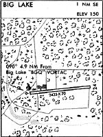
Navigation Aids (Navaids) near BGQ
| Dist (NM) | ID | Morse Code | Name | Type | Freq | True Hdg | Mag Hdg |
|---|---|---|---|---|---|---|---|
| 4.9 | BGQ | _ . . . _ _ . _ _ . _ | Big Lake | VORTAC | 112.50 | 295 | 280 |
| 16.8 | EDF | . _ . . . . _ . | Elmendorf | TACAN | 113.40 | 175 | 160 |
| 19.1 | MRI | _ _ . _ . . . | Anchorage | VOT | 111.00 | 182 | 167 |
| 22.4 | TED | _ . _ . . | Anchorage | VOR-DME | 113.15 | 190 | 175 |
| 22.7 | ANC | . _ _ . _ . _ . | Anchorage | VOT | 108.40 | 193 | 178 |
| 22.8 | CMQ | _ . _ . _ _ _ _ . _ | Campbell Lake | NDB | 338 | 197 | 182 |
| 46.6 | TKA | _ _ . _ . _ | Talkeetna | VOR-DME | 116.20 | 349 | 334 |
| 48.4 | PEE | . _ _ . . . | Peters Creek | NDB | 305 | 350 | 335 |
| 68.2 | ENA | . _ . . _ | Kenai | VOR-DME | 117.60 | 216 | 201 |
| 69.3 | IWW | . . . _ _ . _ _ | Wildwood | NDB | 379 | 216 | 202 |
| 70.7 | OLT | _ _ _ . _ . . _ | Soldotna | NDB-DME | 346 | 206 | 191 |
Nearby Airports with Fuel
| Dist (NM) | Name (Airport IDs) | True Hdg | Mag Hdg | Fuel Grade |
|---|---|---|---|---|
| 8.1 | Wasilla Airport (WWA PAWS IYS) |
73 | 58 | 100LL, Jet A |
| 11.3 | Birchwood Airport (PABV BCV) |
129 | 114 | 100LL |
| 12.0 | Wasilla Lake Seaplane Base (5L6) |
74 | 59 | 100LL |
| 19.3 | Merrill Field Airport (MRI PAMR MRI) |
182 | 167 | 100, Jet A |
| 19.3 | Alaska Regional Hospital Heliport (2OK) |
181 | 166 | 100LL, Jet A |
| 21.0 | Warren 'Bud' Woods Palmer Municipal Airport (PAQ PAAQ PAQ) |
79 | 64 | 100LL, Jet A-1 |
| 22.3 | Ted Stevens Anchorage International Airport (ANC PANC ANC) |
193 | 178 | 100, 100LL, Jet A, Jet A-1 |
| 47.9 | Talkeetna Airport (TKA PATK TKA) |
350 | 335 | 100LL, Jet A, Jet A+ |
| 71.1 | Kenai Municipal Airport (ENA PAEN ENA) |
216 | 202 | 100LL, Jet A |
| 72.9 | Soldotna Airport (SXQ PASX SXQ) |
209 | 195 | 100LL, Jet A |
Notices to Airmen (NOTAMS)
Remarks
| A110-1 | LOW FLYING ACFT INVOF APCH TO BIG LAKE VOR. |
| A110-10 | ARPT HAS DESIGNATED TRANSIENT ACFT PARKING AVBL. TRANSIENT ACFT PARKING IS DESIGNATED WITH GREEN CONES. |
| A110-12 | BE ALERT: FROST HEAVE ON RY APRXLY 2200 FT. |
| A110-2 | RY COND NOT MONITORED; RECOMMEND VISUAL INSPECTION PRIOR TO USE. |
| A110-3 | UPDRAFT OFF OF RISING HILL ON APCH TO RY 25. |
| A110-5 | RY 07+15' ROAD PARALLEL TO RY END. |
| A110-7 | 190 FT AGL LIGHTED TWR 2 NM NE OF ARPT. |
| A110-9 | BE ALERT: OCCASIONAL ULTRA LIGHT TRAFFIC. |
| A81-APT | ACTVT MIRL RY 07/25 - 122.8 |
Runways
Runway Summary
| Runways: | 07/25 |
| Longest Runway: | 07/25 is 2450 ft (747 m) long |
| Runways with an Instrument Approach: |
BGQ Airport Runway Details
| Runway 07/25 | 2450 ft x 70 ft (747 m x 21 m) | |
| Runway Length Source: | 3RD PARTY SURVEY as of 08/23/2018 | |
| Surface: | Gravel - Good condition - No special surface treatment | |
| Runway Edge Lights: | Medium Intensity | |
Runway 07 |
Runway 25 |
|
Elevation: |
161.0 | 158.3 |
Latitude: |
61-32-04.8626N | 61-32-04.8546N |
Longitude: |
149-49-10.4396W | 149-48-19.9090W |
|
Runway True Alignment: |
090 | 270 |
Glide Path Angle: |
0.0 degrees | 0.0 degrees |
Traffic Pattern: |
Left | Left |
Runway Markings Type: |
Nonstandard (other than numbers only) | Nonstandard (other than numbers only) |
Runway Markings Condition: |
Good | Good |
Object at End: |
TREES | TREES |
Object Height: |
60 | 50 |
Distance from End: |
0 | 0 |
Object Centerline Offset: |
200 ft. right of centerline | 207 ft. left of centerline |
REIL: |
No | No |
Services
Airframe Repair: |
Major |
Powerplant Repair: |
Major |
Fuel Available: |
100LL, Jet A |
Landing Fees: |
Yes |
Parking: |
Tiedowns available |
Maps & Diagrams
BGQ Sectional
Flight Planning
at skyvector.com
at skyvector.com