
Location
Latitude: |
44-49-06.2448N (44.818401) |
Longitude: |
020-18-32.7571E (20.309099) |
Elevation: |
335 feet MSL (102 m MSL) |
Magnetic Variation: |
5.5 E (as of April 2024 from WMM2020 model) |
Time Zone: |
UTC +1.0 (Standard Time) UTC +2.0 (Daylight Savings Time) |
Contacts
Manager: |
: |
Operations
Airport Status: |
Operational |
Facility Use: |
Public |
Type: |
Airport |
Traffic Pattern Altitude (MSL): |
1335 feet (407 m) |
Based Aircraft
Annual Operations (as of )
Communications
| INFO: | 122.925 |
| TWR: | 118.1 |
| APP: | 119.1 |
| APP: | 133.1 |
Fixed Based Operators (FBOs) & Fuel
(Click on a business for detail)
Please help us keep this information up to date. This is a FREE SERVICE just like everything else on Airport Guide! If you see that a business needs to be added, modified, or deleted please fill out our Update Form.
To add, modify, or delete a business click here.
Please help us keep this information up to date. This is a FREE SERVICE just like everything else on Airport Guide! If you see that a business needs to be added, modified, or deleted please fill out our Update Form.
| Business Name | Frequency | Phone | Fuel Grade |
|---|
Flight Service Stations
| Primary | Alternate | |
| FSS on Field: | ||
| FSS Name (ID): | ||
| Frequency: | ||
| Toll Free Phone: |
Instrument Procedures / Charts
Terminal Procedures are only available for airports in several countries with more being added all the time. If you are looking for a specific country's charts, please send an email to support(at)airportguide.com stating the country name. This will be used to prioritize the implementation.
Navigation Aids (Navaids) near BEG
| Dist (NM) | ID | Morse Code | Name | Type | Freq | True Hdg | Mag Hdg |
|---|---|---|---|---|---|---|---|
| 0.1 | BGD | Beograd | VOR-DME | 112.05 | 57 | 52 | |
| 8.4 | JA | Beograd | NDB | 316 | 122 | 116 | |
| 8.7 | KN | Beograd | NDB | 380 | 301 | 296 | |
| 12.8 | OBR | Beograd | NDB | 355 | 214 | 209 | |
| 14.8 | PA | Pancevo | NDB | 495 | 72 | 66 | |
| 16.8 | IA | Indija | NDB | 485 | 323 | 318 | |
| 31.6 | SMR | Mitrovica | NDB | 328 | 290 | 285 | |
| 35.0 | VAL | Valjevo | VOR-DME | 116.60 | 212 | 207 | |
| 35.1 | VAL | Valjevo | NDB | 390 | 212 | 207 | |
| 36.5 | DAK | Dakovica | NDB | 412 | 7 | 1 | |
| 37.7 | POZ | Pozarevac | NDB | 416 | 108 | 102 | |
| 39.0 | SMI | Mitrovica | VOR-DME | 117.00 | 287 | 282 | |
| 44.6 | TPL | Topola | VOR-DME | 116.80 | 155 | 150 | |
| 44.7 | VRA | Vrsac | NDB | 294 | 68 | 62 | |
| 44.8 | TPL | Topola | NDB | 348 | 155 | 150 | |
| 46.4 | VAC | Vrsac | VOR | 115.60 | 65 | 59 | |
| 51.5 | VEG | Gradiste | NDB | 324 | 93 | 87 | |
| 66.3 | MGV | Mcgovern | NDB | 376 | 272 | 267 | |
| 69.5 | VTN | Kraljevo | NDB | 468 | 161 | 156 | |
| 70.8 | TUZ | Tuzla | TACAN | 109.70 | 252 | 247 |
Nearby Airports with Fuel
| Dist (NM) | Name (Airport IDs) | True Hdg | Mag Hdg | Fuel Grade |
|---|---|---|---|---|
| 74.3 | Osijek Airport (LDOS) |
301 | 296 | 100LL Avgas |
| 76.6 | Subotica Airport (LYSU) |
340 | 334 | 100LL |
Notices to Airmen (NOTAMS)
Remarks
No remarks for this landing facility
Runways
Runway Summary
| Runways: | 12L/30R 12R/30L |
| Longest Runway: | 12R/30L is 11483 ft (3500 m) long |
| Runways with an Instrument Approach: |
BEG Airport Runway Details
| Runway 12L/30R | 11155 ft x 148 ft (3400 m x 45 m) | |
| Runway Edge Lights: | Yes Intensity | |
Runway 12L |
Runway 30R |
|
Elevation: |
318 | 335 |
Latitude: |
44.826519 | 44.810333 |
Longitude: |
20.29097 | 20.327454 |
|
Runway True Alignment: |
122 | 302 |
Glide Path Angle: |
0.0 degrees | 0.0 degrees |
REIL: |
Yes | Yes |
Threshold Elevation: |
318 | 335 |
Displaced Threshold: |
1312 |
| Runway 12R/30L | 11483 ft x 148 ft (3500 m x 45 m) | |
| Runway Edge Lights: | Yes Intensity | |
Runway 12R |
Runway 30L |
|
Elevation: |
326 | 326 |
Latitude: |
44.824989 | 44.808315 |
Longitude: |
20.289886 | 20.327484 |
Glide Path Angle: |
0.0 degrees | 0.0 degrees |
REIL: |
Yes | Yes |
Threshold Elevation: |
326 | 326 |
Services
Fuel Available: |
100LL |
Other Services: |
Drop Zone for skydiving - Tandem jumps Paragliding Motor kite flights and training |
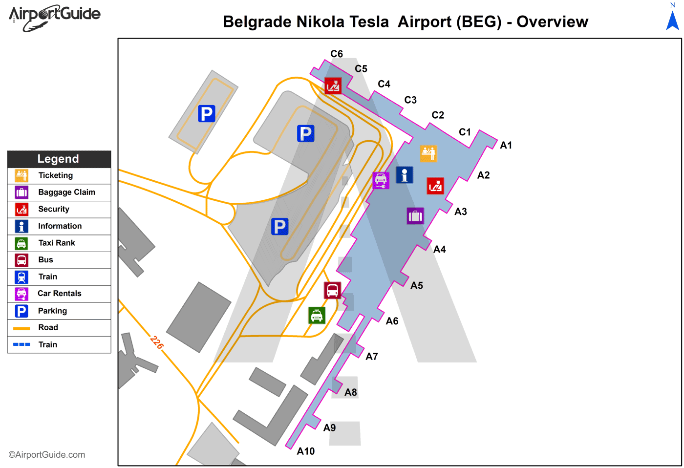
Maps & Diagrams
BEG Sectional
Flight Planning
at skyvector.com
at skyvector.com
