Location
Latitude: |
40-06-31.0000N (40.108611) |
Longitude: |
085-36-46.8000W (-85.613) |
Elevation: |
919.1 feet MSL (280 m MSL) |
Magnetic Variation: |
5.4 W (as of April 2024 from WMM2020 model) |
Time Zone: |
UTC -5.0 (Standard Time) UTC -4.0 (Daylight Savings Time) |
From City: |
03 N.M. E of Anderson, Indiana |
Found On: |
Chicago Chart |
FAA Region: |
AGL |
Contacts
Manager: |
Publicly owned: |
| BRIAN MCMILLEN 282 AIRPORT RD. ANDERSON, IN 46017 765-648-6292 |
CITY OF ANDERSON 282 AIRPORT RD ANDERSON, IN 46017 765-648-6293 |
Operations
Airport Status: |
Operational |
Facility Use: |
Public |
Type: |
Airport |
Activation Date: |
10/1959 |
Control tower: |
Yes |
Attendance (Months/Days/Hours): |
Months/Days/Hours ALL/MON-FRI/0700-1800 |
Boundary ARTCC: |
ZID (Indianapolis) |
Responsible ARTCC: |
ZID (Indianapolis) |
Lighting Schedule: |
SEE RMK |
Segmented Circle Indicator: |
Yes |
Traffic Pattern Altitude (MSL): |
1919 feet (585 m) |
NOTAMs Facility: |
AID |
NOTAM-D Service: |
Yes |
International Airport of Entry: |
No |
Customs Landing Rights: |
No |
Military Landing Rights: |
Yes |
Civil/Military Joint Use: |
No |
Based Aircraft
| Single Engine: | 97 |
| Multi Engine: | 7 |
| GA Helicopters: | 2 |
Annual Operations (as of 12/31/2019)
| Total Operations: | 19359 | |
| Air Taxi: | 1162 | 6.0% |
| GA Local: | 9292 | 48.0% |
| GA Itinerant: | 8712 | 45.0% |
| Military Aircraft: | 193 | 1.0% |
Communications
| CTAF: | 126.000 |
| Unicom: | 122.950 |
| Tower: | ANDERSON 126.0 Hrs: 0830-1630 MON-SAT |
| Ground: | 121.6 |
| Approach: | INDIANAPOLIS 120.65 120.65 |
| Departure: | INDIANAPOLIS 120.65 120.65 |
| AWOS-3: | 128.55 (765-442-1245) |
- APCH/DEP SVC PRVDD BY INDIANAPOLIS TRACON ON FREQS 120.65/317.8.
Fixed Based Operators (FBOs) & Fuel
(Click on a business for detail)
Please help us keep this information up to date. This is a FREE SERVICE just like everything else on Airport Guide! If you see that a business needs to be added, modified, or deleted please fill out our Update Form.
To add, modify, or delete a business click here.
Please help us keep this information up to date. This is a FREE SERVICE just like everything else on Airport Guide! If you see that a business needs to be added, modified, or deleted please fill out our Update Form.
Area Code: 765 |
| Business Name | Frequency | Phone | Fuel Grade |
|---|---|---|---|
| Anderson Aviation, Inc.
Update FBO info |
Unicom 122.95 | 644-1238 | 100LL, Mogas, Jet A |
Flight Service Stations
| Primary | Alternate | |
| FSS on Field: | N | |
| FSS Name (ID): | Terre Haute(HUF) | |
| Frequency: | ||
| Toll Free Phone: | 1-800-WX-BRIEF |
Instrument Procedures / Charts
FAA Terminal Procedures valid from 0901Z 03/21/24 to 0901Z 04/18/24.
There are various types of charts available for an airport. They are listed in the Page Type column. Here is a legend for those types:
APD - Airport Diagram
DP - Departure Procedure Charts
HOT - Hot Spots
IAP - Instrument Approach Procedure Charts
MIN - Minimums
STAR - Standard Terminal Arrival Charts
| Page Type | Page Name | Volume | Action Since Last Cycle |
|---|---|---|---|
| APD | AIRPORT DIAGRAM | EC-2 | |
| IAP | ILS OR LOC RWY 30 | EC-2 | |
| IAP | RNAV (GPS) RWY 12 | EC-2 | |
| IAP | RNAV (GPS) RWY 30 | EC-2 | |
| MIN | ALTERNATE MINIMUMS | EC-2 | |
| MIN | TAKEOFF MINIMUMS | EC-2 |
Terminal Procedures are only available for airports in several countries with more being added all the time. If you are looking for a specific country's charts, please send an email to support(at)airportguide.com stating the country name. This will be used to prioritize the implementation.
Navigation Aids (Navaids) near AID
| Dist (NM) | ID | Morse Code | Name | Type | Freq | True Hdg | Mag Hdg |
|---|---|---|---|---|---|---|---|
| 5.2 | AI | . _ . . | Video | NDB | 394 | 116 | 121 |
| 12.7 | MIE | _ _ . . . | Muncie | VOR-DME | 114.40 | 52 | 58 |
| 14.1 | JN | . _ _ _ _ . | Balll | NDB | 365 | 71 | 77 |
| 19.3 | UWL | . . _ . _ _ . _ . . | New Castle | NDB | 385 | 135 | 141 |
| 22.6 | UMP | . . _ _ _ . _ _ . | Metropolitan | NDB | 338 | 243 | 248 |
| 23.3 | MZZ | _ _ _ _ . . _ _ . . | Marion | VOR-DME | 108.60 | 352 | 357 |
| 29.8 | SQ | . . . _ _ . _ | Pnthr | NDB | 227 | 131 | 137 |
| 30.2 | SHB | . . . . . . . _ . . . | Shelbyville | VOR-DME | 116.15 | 198 | 203 |
| 32.4 | OKK | _ _ _ _ . _ _ . _ | Kokomo | TACAN | 113.50 | 321 | 326 |
| 36.0 | HFY | . . . . . . _ . _ . _ _ | Greenwood | NDB | 398 | 217 | 222 |
| 38.9 | VHP | . . . _ . . . . . _ _ . | Brickyard | VORTAC | 116.30 | 243 | 248 |
| 39.1 | IND | . . _ . _ . . | Indianapolis Intl | VOT | 109.60 | 235 | 240 |
| 40.2 | IWH | . . . _ _ . . . . | Wabash | NDB | 329 | 347 | 352 |
| 40.5 | GUS | _ _ . . . _ . . . | Grissom | VORTAC | 108.45 | 322 | 327 |
| 41.5 | RID | . _ . . . _ . . | Richmond | DME | 110.6 | 120 | 126 |
| 44.6 | FKR | . . _ . _ . _ . _ . | Frankfort | NDB | 278 | 282 | 287 |
| 45.3 | HHG | . . . . . . . . _ _ . | Huntington | NDB | 417 | 8 | 14 |
| 48.1 | BA | _ . . . . _ | Clifs | NDB | 410 | 191 | 196 |
| 48.6 | HLB | . . . . . _ . . _ . . . | Batesville | NDB | 254 | 160 | 166 |
| 52.7 | OXD | _ _ _ _ . . _ _ . . | Oxford | NDB | 282 | 132 | 138 |
Nearby Airports with Fuel
Notices to Airmen (NOTAMS)
Remarks
| A110-1 | DEP RWY 12, 18 & 36 UN TO SEE EACH OTHER. |
| A110-2 | DEER ON & INVOF ARPT. |
| A110-4 | TWY B CLSD INDEFLY. |
| A110-5 | WHEN ATCT IS CLSD FOR CD CTC INDIANAPOLIS APCH AT 317-227-5743. |
| A110-6 | GND COM OUTLET 121.725 COMMISSIONED KEY FREQ 4 TIMES. |
| A110-8 | TRML NOT STAFFED ON SUNDAYS - AMGR. |
| A110-9 | SELF SERVE FUEL AVBL H24. |
| A17 | UNATNDD MARTIN LUTHER KING, PRES, ELECTION, EASTER, MEMORIAL, INDEPENDENCE, LABOR, VETERANS, THANKSGIVING, CHRISTMAS, NEW YEARS DAYS & GOOD FRIDAY; AFT HR - AMGR. |
| A30-18/36 | NOT AVBL TO ACR MORE THAN 30 PAX SEATS. |
| A57-18 | APCH RATIO 24:1 TO DSPLCD THR. |
| A57-30 | APCH RATIO 35:1 TO DSPLCD THR. |
| A57-36 | APCH RATIO 22:1 TO DSPLCD THR. |
| A58-18 | 11 FT RD 170 FT FM RWY END. |
| A81-APT | WHEN TWR CLSD ACTVT MALSF RWY 30; PAPI RWY 12 & 18; MIRL RWY 12/30 & 18/36 - CTAF. |
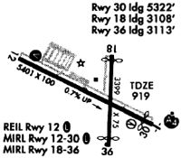
Runways
Runway Summary
| Runways: | 12/30 18/36 |
| Longest Runway: | 12/30 is 5400 ft (1646 m) long |
| Runways with an Instrument Approach: | 30 |
AID Airport Runway Details
| Runway 12/30 | 5400 ft x 100 ft (1646 m x 30 m) | |
| Runway Length Source: | 3RD PARTY SURVEY as of 03/03/2014 | |
| Surface: | Asphalt - Excellent condition - Saw-cut or plastic grooved | |
| Runway Pavement Class: | 44 /F/C/Y/T | |
| Runway Edge Lights: | Medium Intensity | |
Runway Weight Bearing Capacity (in thousands of pounds) |
||
| Single Wheel Landing Gear: | 112.0 | |
| Dual Wheel Landing Gear: | 158.0 | |
| Dual Tandem Wheel Landing Gear: | 279.0 | |
Runway 12 |
Runway 30 |
|
Elevation: |
880.1 | 919.0 |
Latitude: |
40-06-43.0064N | 40-06-20.4257N |
Longitude: |
085-37-22.5803W | 085-36-19.6222W |
|
Runway True Alignment: |
115 | 295 |
ILS Type: |
ILS | |
Glide Path Angle: |
3.0 degrees | 3.0 degrees |
Traffic Pattern: |
Left | Left |
Runway Markings Type: |
Precision Instrument | Precision Instrument |
Runway Markings Condition: |
Good | Good |
Object at End: |
TREES | TREES |
Object Height: |
117 | 50 |
Distance from End: |
1831 | 1700 |
Object Centerline Offset: |
519 ft. right of centerline | 30 ft. left of centerline |
Visual Glide Slope Indicators: |
4-Light PAPI On Left Side Of Runway | 4-Light PAPI On Left Side Of Runway |
Approach Light System: |
1,400 Foot Medium Intensity Approach Lighting System With Sequenced Flashers | |
REIL: |
Yes | No |
Touchdown Lights: |
No | No |
Centerline Lights: |
No | No |
Threshold Crossing Height: |
45 | 48 |
Threshold Elevation: |
918.9 | |
Displaced Threshold: |
80 | |
Threshold Latitude: |
40-06-20.7583N | |
Threshold Longitude: |
085-36-20.5496W |
| Runway 18/36 | 3399 ft x 75 ft (1036 m x 23 m) | |
| Runway Length Source: | 3RD PARTY SURVEY as of 03/03/2014 | |
| Surface: | Asphalt - Excellent condition - Saw-cut or plastic grooved | |
| Runway Pavement Class: | 14 /F/C/Y/T | |
| Runway Edge Lights: | Medium Intensity | |
Runway Weight Bearing Capacity (in thousands of pounds) |
||
| Single Wheel Landing Gear: | 38.5 | |
| Dual Wheel Landing Gear: | 56.5 | |
Runway 18 |
Runway 36 |
|
Elevation: |
912.7 | 908.0 |
Latitude: |
40-06-46.7050N | 40-06-13.1188N |
Longitude: |
085-36-39.9503W | 085-36-39.8630W |
|
Runway True Alignment: |
180 | 360 |
Glide Path Angle: |
3.0 degrees | 0.0 degrees |
Traffic Pattern: |
Left | Left |
Runway Markings Type: |
Basic | Basic |
Runway Markings Condition: |
Fair | Fair |
Object at End: |
TREE | TREES |
Object Height: |
63 | 98 |
Distance from End: |
1314 | 1900 |
Object Centerline Offset: |
519 ft. right of centerline | 30 ft. left of centerline |
Visual Glide Slope Indicators: |
2-Light PAPI On Left Side Of Runway | |
REIL: |
No | No |
Touchdown Lights: |
No | No |
Centerline Lights: |
No | No |
Threshold Crossing Height: |
30 | |
Threshold Elevation: |
912.2 | 907.5 |
Displaced Threshold: |
291 | 288 |
Threshold Latitude: |
40-06-43.8285N | 40-06-15.9647N |
Threshold Longitude: |
085-36-39.9424W | 085-36-39.8699W |
Declared Distances |
||
Landing Dist. Avbl. (LDA): |
3108 | 3111 |
Services
Airframe Repair: |
Minor |
Powerplant Repair: |
Minor |
Fuel Available: |
100LL, Jet A |
Landing Fees: |
No |
Parking: |
Hangars and tiedowns available |
Maps & Diagrams
AID Sectional
Flight Planning
at skyvector.com
at skyvector.com