Location
Latitude: |
41-35-21.6770N (41.589355) |
Longitude: |
075-45-21.8900W (-75.756081) |
Elevation: |
1209.0 feet MSL (369 m MSL) |
Magnetic Variation: |
11.9 W (as of April 2024 from WMM2020 model) |
Time Zone: |
UTC -5.0 (Standard Time) UTC -4.0 (Daylight Savings Time) |
From City: |
02 N.M. N of Factoryville, Pennsylvania |
Found On: |
New York Chart |
FAA Region: |
AEA |
Contacts
Manager: |
Privately owned: |
| JASON CORBY 65 WINDSOCK LANE FACTORYVILLE, PA 18419 570-945-5125 |
RMB AVIATION LLC 65 WINDSOCK LANE FACTORYVILLE, PA 18419 570-945-5125 |
Operations
Airport Status: |
Operational |
Facility Use: |
Public |
Type: |
Airport |
Activation Date: |
02/1971 |
Control tower: |
No |
Attendance (Months/Days/Hours): |
Months/Days/Hours ALL/ALL/0900-1700 |
Boundary ARTCC: |
ZNY (New York) |
Responsible ARTCC: |
ZNY (New York) |
Lighting Schedule: |
SS-SR |
Segmented Circle Indicator: |
No |
Traffic Pattern Altitude (MSL): |
2209 feet (673 m) |
NOTAMs Facility: |
IPT |
NOTAM-D Service: |
Yes |
International Airport of Entry: |
No |
Customs Landing Rights: |
No |
Based Aircraft
| Single Engine: | 35 |
| GA Helicopters: | 1 |
| Ultralights: | 1 |
Annual Operations (as of 11/30/2023)
| Total Operations: | 14111 | |
| Air Taxi: | 101 | 0.7% |
| GA Local: | 10500 | 74.4% |
| GA Itinerant: | 3500 | 24.8% |
| Military Aircraft: | 10 | 0.1% |
Communications
| CTAF: | 122.700 |
| Unicom: | 122.700 |
| Approach: | WILKES-BARRE 120.95 120.95 |
| Departure: | WILKES-BARRE 120.95 120.95 |
Fixed Based Operators (FBOs) & Fuel
(Click on a business for detail)
Please help us keep this information up to date. This is a FREE SERVICE just like everything else on Airport Guide! If you see that a business needs to be added, modified, or deleted please fill out our Update Form.
To add, modify, or delete a business click here.
Please help us keep this information up to date. This is a FREE SERVICE just like everything else on Airport Guide! If you see that a business needs to be added, modified, or deleted please fill out our Update Form.
Area Code: 570 |
| Business Name | Frequency | Phone | Fuel Grade |
|---|
Flight Service Stations
| Primary | Alternate | |
| FSS on Field: | N | |
| FSS Name (ID): | Williamsport(IPT) | |
| Frequency: | ||
| Toll Free Phone: | 1-800-WX-BRIEF |
Instrument Procedures / Charts
FAA Terminal Procedures valid from 0901Z 03/21/24 to 0901Z 04/18/24.
There are various types of charts available for an airport. They are listed in the Page Type column. Here is a legend for those types:
APD - Airport Diagram
DP - Departure Procedure Charts
HOT - Hot Spots
IAP - Instrument Approach Procedure Charts
MIN - Minimums
STAR - Standard Terminal Arrival Charts
| Page Type | Page Name | Volume | Action Since Last Cycle |
|---|---|---|---|
| IAP | RNAV (GPS) RWY 04 | NE-4 | |
| MIN | TAKEOFF MINIMUMS | NE-4 |
Terminal Procedures are only available for airports in several countries with more being added all the time. If you are looking for a specific country's charts, please send an email to support(at)airportguide.com stating the country name. This will be used to prioritize the implementation.
Navigation Aids (Navaids) near 9N3
| Dist (NM) | ID | Morse Code | Name | Type | Freq | True Hdg | Mag Hdg |
|---|---|---|---|---|---|---|---|
| 14.0 | LHY | . _ . . . . . . _ . _ _ | Lake Henry | VORTAC | 110.80 | 118 | 130 |
| 19.2 | LVZ | . _ . . . . . _ _ _ . . | Wilkes-Barre | VORTAC | 111.60 | 171 | 183 |
| 31.5 | BG | _ . . . _ _ . | Smite | NDB | 332 | 348 | 360 |
| 34.6 | HNK | . . . . _ . _ . _ | Hancock | VOR-DME | 116.80 | 34 | 46 |
| 38.1 | CFB | _ . _ . . . _ . _ . . . | Binghamton | VOR-DME | 112.20 | 333 | 345 |
| 40.4 | HZL | . . . . _ _ . . . _ . . | Hazleton | VOR | 109.40 | 204 | 216 |
| 41.5 | MS | _ _ . . . | Monga | NDB | 359 | 74 | 86 |
| 46.8 | PIX | . _ _ . . . _ . . _ | Picture Rocks | NDB | 344 | 246 | 258 |
| 48.2 | FQM | . . _ . _ _ . _ _ _ | Williamsport | VOR-DME | 114.40 | 252 | 264 |
| 50.2 | DNY | _ . . _ . _ . _ _ | Delancey | VOR-DME | 112.10 | 45 | 57 |
| 53.2 | MIP | _ _ . . . _ _ . | Milton | VORTAC | 109.20 | 230 | 242 |
| 53.4 | HUO | . . . . . . _ _ _ _ | Huguenot | VOR-DME | 116.10 | 101 | 113 |
| 53.5 | FJC | . . _ . . _ _ _ _ . _ . | Allentown | VORTAC | 117.50 | 165 | 177 |
| 53.5 | STW | . . . _ . _ _ | Stillwater | VOR-DME | 109.60 | 131 | 143 |
| 57.3 | IT | . . _ | Vrnah | NDB | 266 | 331 | 343 |
| 57.4 | RKA | . _ . _ . _ . _ | Rockdale | VOR-DME | 112.60 | 23 | 35 |
| 59.5 | ALP | . _ . _ . . . _ _ . | Alpine | NDB | 245 | 311 | 323 |
| 60.6 | ETX | . _ _ . . _ | East Texas | VOR-DME | 110.20 | 176 | 188 |
| 62.7 | ITH | . . _ . . . . | Ithaca | DME | 111.8 | 330 | 342 |
| 63.2 | SAX | . . . . _ _ . . _ | Sparta | VORTAC | 115.70 | 119 | 131 |
Nearby Airports with Fuel
Notices to Airmen (NOTAMS)
Remarks
| A110*G | THIS AIRPORT HAS BEEN SURVEYED BY THE NATIONAL GEODETIC SURVEY. |
| A110-1 | FOR CD CTC WILKES-BARRE APCH AT 570-655-2084. |
| A17 | FOR SVC AFT HRS CTC 570-945-5125. |
| A58-04 | 13 FT BRUSH 127 FT FM THLD 62 FT RIGHT. |
| A58-22 | 37 FT TREES 87 FT FM THLD 207 FT RIGHT. |
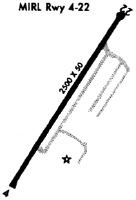
Runways
Runway Summary
| Runways: | 04/22 |
| Longest Runway: | 04/22 is 2500 ft (762 m) long |
| Runways with an Instrument Approach: |
9N3 Airport Runway Details
| Runway 04/22 | 2500 ft x 50 ft (762 m x 15 m) | |
| Runway Length Source: | OWNER as of 10/17/2006 | |
| Surface: | Asphalt - Good condition - No special surface treatment | |
| Runway Edge Lights: | Low Intensity | |
Runway 04 |
Runway 22 |
|
Elevation: |
1184.2 | 1203.4 |
Latitude: |
41-35-08.1164N | 41-35-30.7066N |
Longitude: |
075-45-29.8256W | 075-45-16.5495W |
|
Runway True Alignment: |
024 | 204 |
Glide Path Angle: |
0.0 degrees | 0.0 degrees |
Traffic Pattern: |
Left | Left |
Runway Markings Type: |
Nonprecision Instrument | Basic |
Runway Markings Condition: |
Good | Good |
Services
Airframe Repair: |
None |
Powerplant Repair: |
None |
Bottled Oxygen: |
None |
Bulk Oxygen: |
None |
Fuel Available: |
100LL, Jet A |
Landing Fees: |
Yes |
Parking: |
Tiedowns available |
Maps & Diagrams
9N3 Sectional
Flight Planning
at skyvector.com
at skyvector.com