Location
Latitude: |
37-32-44.5000N (37.545694) |
Longitude: |
099-38-31.8000W (-99.642167) |
Elevation: |
2418.0 feet MSL (737 m MSL) |
Magnetic Variation: |
4.5 E (as of April 2024 from WMM2020 model) |
Time Zone: |
UTC -6.0 (Standard Time) UTC -5.0 (Daylight Savings Time) |
From City: |
01 N.M. SW of Bucklin, Kansas |
Found On: |
Wichita Chart |
FAA Region: |
ACE |
Contacts
Manager: |
Privately owned: |
| LARRY RANDALL BOX 641 BUCKLIN, KS 67834 620-826-5519 |
LARRY RANDALL P.O. BOX 641 BUCKLIN, KS 67834 620-826-5519 |
Operations
Airport Status: |
Operational |
Facility Use: |
Public |
Type: |
Airport |
Activation Date: |
12/1946 |
Control tower: |
No |
Attendance (Months/Days/Hours): |
Months/Days/Hours Unattended |
Boundary ARTCC: |
ZKC (Kansas City) |
Responsible ARTCC: |
ZKC (Kansas City) |
Segmented Circle Indicator: |
No |
Traffic Pattern Altitude (MSL): |
3418 feet (1042 m) |
NOTAMs Facility: |
ICT |
NOTAM-D Service: |
Yes |
Based Aircraft
| Single Engine: | 1 |
Annual Operations (as of 08/30/2021)
| Total Operations: | 1500 | |
| GA Local: | 1200 | 80.0% |
| GA Itinerant: | 300 | 20.0% |
Communications
| CTAF: | 122.900 |
Fixed Based Operators (FBOs) & Fuel
(Click on a business for detail)
Please help us keep this information up to date. This is a FREE SERVICE just like everything else on Airport Guide! If you see that a business needs to be added, modified, or deleted please fill out our Update Form.
To add, modify, or delete a business click here.
Please help us keep this information up to date. This is a FREE SERVICE just like everything else on Airport Guide! If you see that a business needs to be added, modified, or deleted please fill out our Update Form.
Area Code: 620 |
| Business Name | Frequency | Phone | Fuel Grade |
|---|
Flight Service Stations
| Primary | Alternate | |
| FSS on Field: | N | |
| FSS Name (ID): | Wichita(ICT) | |
| Frequency: | ||
| Toll Free Phone: | 1-800-WX-BRIEF |
Instrument Procedures / Charts
Terminal Procedures are only available for airports in several countries with more being added all the time. If you are looking for a specific country's charts, please send an email to support(at)airportguide.com stating the country name. This will be used to prioritize the implementation.
Navigation Aids (Navaids) near 8K0
| Dist (NM) | ID | Morse Code | Name | Type | Freq | True Hdg | Mag Hdg |
|---|---|---|---|---|---|---|---|
| 25.1 | DDC | _ . . _ . . _ . _ . | Dodge City | VORTAC | 108.20 | 316 | 311 |
| 40.9 | BFK | _ . . . . . _ . _ . _ | Buffalo | NDB | 215 | 178 | 174 |
| 43.9 | PTT | . _ _ . _ _ | Pratt | NDB | 356 | 75 | 71 |
| 47.4 | LQR | . _ . . _ _ . _ . _ . | Larned | NDB | 296 | 33 | 29 |
| 54.1 | GC | _ _ . _ . _ . | Pieve | NDB | 347 | 288 | 283 |
| 56.1 | GCK | _ _ . _ . _ . _ . _ | Garden City | VORTAC | 113.30 | 293 | 288 |
| 56.4 | GB | _ _ . _ . . . | Babsy | NDB | 419 | 41 | 37 |
| 60.0 | HIL | . . . . . . . _ . . | Hilyn | NDB | 338 | 35 | 31 |
| 67.1 | MDF | _ _ _ . . . . _ . | Mooreland | NDB | 284 | 161 | 157 |
| 70.2 | LBL | . _ . . _ . . . . _ . . | Liberal | TACAN | 112.30 | 245 | 240 |
| 71.8 | LB | . _ . . _ . . . | Panck | NDB | 383 | 241 | 236 |
| 73.0 | MMB | _ _ _ _ _ . . . | Mitbee | VORTAC | 115.60 | 189 | 184 |
| 73.9 | ANY | . _ _ . _ . _ _ | Anthony | TACAN | 112.90 | 107 | 103 |
| 75.7 | HY | . . . . _ . _ _ | Nette | NDB | 374 | 13 | 9 |
| 80.0 | HYS | . . . . _ . _ _ . . . | Hays | VORTAC | 110.40 | 12 | 8 |
| 81.3 | TQK | _ _ _ . _ _ . _ | Scott City | NDB | 256 | 313 | 308 |
| 82.1 | ULS | . . _ . _ . . . . . | Ulysses | NDB | 395 | 272 | 267 |
| 82.4 | LYO | . _ . . _ . _ _ _ _ _ | Lyons | NDB | 386 | 53 | 49 |
| 85.4 | HUT | . . . . . . _ _ | Hutchinson | VOR-DME | 116.80 | 70 | 66 |
| 85.8 | HQG | . . . . _ _ . _ _ _ . | Hugoton | NDB | 365 | 255 | 250 |
Nearby Airports with Fuel
Notices to Airmen (NOTAMS)
Remarks
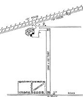
| A110-1 | RWY 18 HAS +20' BLDG 120' FROM RWY END 50' R OF CNTRLN; +15' ROAD 60' FROM RWY END L & R. |
| A110-2 | FOR CD CTC KANSAS CITY ARTCC AT 913-254-8508. |
Runways
Runway Summary
| Runways: | 18/36 |
| Longest Runway: | 18/36 is 2560 ft (780 m) long |
| Runways with an Instrument Approach: |
8K0 Airport Runway Details
| Runway 18/36 | 2560 ft x 150 ft (780 m x 46 m) | |
| Surface: | Turf - Fair condition - No special surface treatment | |
Runway 18 |
Runway 36 |
|
Elevation: |
2418.0 | 2403.0 |
Latitude: |
37-32-57.1152N | 37-32-31.8003N |
Longitude: |
099-38-31.6485W | 099-38-31.9291W |
|
Runway True Alignment: |
181 | 001 |
Glide Path Angle: |
0.0 degrees | 0.0 degrees |
Traffic Pattern: |
Left | Left |
Object at End: |
POLE | ROAD |
Object Height: |
25 | 15 |
Distance from End: |
100 | 0 |
Object Centerline Offset: |
120 ft. right of centerline | 0 ft. left and right of centerline |
Services
Airframe Repair: |
Major |
Powerplant Repair: |
Major |
Bottled Oxygen: |
None |
Bulk Oxygen: |
None |
Fuel Available: |
100LL, Jet A |
Landing Fees: |
No |
Parking: |
Hangars and tiedowns available |
Maps & Diagrams
8K0 Sectional
Flight Planning
at skyvector.com
at skyvector.com