Location
Latitude: |
40-52-57.6994N (40.882694) |
Longitude: |
080-52-51.6816W (-80.881023) |
Elevation: |
1327.0 feet MSL (404 m MSL) |
Magnetic Variation: |
8.8 W (as of April 2024 from WMM2020 model) |
Time Zone: |
UTC -5.0 (Standard Time) UTC -4.0 (Daylight Savings Time) |
From City: |
02 N.M. SW of Salem, Ohio |
Found On: |
Detroit Chart |
FAA Region: |
AGL |
Contacts
Manager: |
Privately owned: |
| DAVID & HARRY KOONS 1760 STATE ROUTE 9 SALEM, OH 44460-9583 330-337-7303 |
DAVID & HARRY KOONS 1760 STATE ROUTE 9 SALEM, OH 44460-9583 330-337-7303 |
Operations
Airport Status: |
Operational |
Facility Use: |
Public |
Type: |
Airport |
Control tower: |
No |
Attendance (Months/Days/Hours): |
Months/Days/Hours Unattended |
Boundary ARTCC: |
ZOB (Cleveland) |
Responsible ARTCC: |
ZOB (Cleveland) |
Segmented Circle Indicator: |
No |
Traffic Pattern Altitude (MSL): |
2327 feet (709 m) |
NOTAMs Facility: |
CLE |
NOTAM-D Service: |
Yes |
International Airport of Entry: |
No |
Customs Landing Rights: |
No |
Military Landing Rights: |
No |
Civil/Military Joint Use: |
No |
Based Aircraft
| Single Engine: | 5 |
| Ultralights: | 2 |
Annual Operations (as of 06/21/2023)
| Total Operations: | 550 | |
| GA Local: | 500 | 90.9% |
| GA Itinerant: | 50 | 9.1% |
Communications
| CTAF: | 122.900 |
Fixed Based Operators (FBOs) & Fuel
(Click on a business for detail)
Please help us keep this information up to date. This is a FREE SERVICE just like everything else on Airport Guide! If you see that a business needs to be added, modified, or deleted please fill out our Update Form.
To add, modify, or delete a business click here.
Please help us keep this information up to date. This is a FREE SERVICE just like everything else on Airport Guide! If you see that a business needs to be added, modified, or deleted please fill out our Update Form.
Area Code: 330 |
| Business Name | Frequency | Phone | Fuel Grade |
|---|
Flight Service Stations
| Primary | Alternate | |
| FSS on Field: | N | |
| FSS Name (ID): | Cleveland(CLE) | |
| Frequency: | ||
| Toll Free Phone: | 1-800-WX-BRIEF |
Instrument Procedures / Charts
Terminal Procedures are only available for airports in several countries with more being added all the time. If you are looking for a specific country's charts, please send an email to support(at)airportguide.com stating the country name. This will be used to prioritize the implementation.
Navigation Aids (Navaids) near 8G8
| Dist (NM) | ID | Morse Code | Name | Type | Freq | True Hdg | Mag Hdg |
|---|---|---|---|---|---|---|---|
| 19.8 | ACO | . _ _ . _ . _ _ _ | Akron | VOR-DME | 114.40 | 313 | 322 |
| 22.7 | HBD | . . . . _ . . . _ . . | Hubbard | NDB | 408 | 44 | 53 |
| 22.7 | UCP | . . _ _ . _ . . _ _ . | Castle | NDB | 272 | 68 | 77 |
| 23.0 | YN | _ . _ _ _ . | Fetch | NDB | 338 | 33 | 42 |
| 25.5 | CAK | _ . _ . . _ _ . _ | Akron/Canton Regional | VOT | 110.60 | 274 | 283 |
| 25.5 | AK | . _ _ . _ | Akron | NDB | 362 | 296 | 305 |
| 26.4 | BSV | _ . . . . . . . . . _ | Briggs | VOR-DME | 112.40 | 251 | 260 |
| 28.5 | YNG | _ . _ _ _ . _ _ . | Youngstown | VORTAC | 109.00 | 19 | 28 |
| 30.6 | EWC | . . _ _ _ . _ . | Ellwood City | VOR-DME | 115.80 | 96 | 105 |
| 39.2 | MMJ | _ _ _ _ . _ _ _ | Montour | DME | 112 | 126 | 135 |
| 39.2 | CFX | _ . _ . . . _ . _ . . _ | Cadiz | NDB | 239 | 188 | 197 |
| 40.0 | HLG | . . . . . _ . . _ _ . | Wheeling | VOR-DME | 114.25 | 159 | 168 |
| 40.1 | CXR | _ . _ . _ . . _ . _ . | Chardon | VOR-DME | 112.70 | 341 | 350 |
| 47.7 | CTW | _ . _ . _ . _ _ | Newcomerstown | DME | 111.8 | 214 | 223 |
| 49.5 | MLR | _ _ . _ . . . _ . | Millersburg/Dcmsnd | NDB | 382 | 245 | 253 |
| 52.0 | AIR | . _ . . . _ . | Bellaire | VOR-DME | 117.10 | 176 | 185 |
| 52.7 | AGC | . _ _ _ . _ . _ . | Allegheny | VOR-DME | 110.00 | 133 | 142 |
| 53.0 | LQL | . _ . . _ _ . _ . _ . . | Lakeland | NDB | 263 | 335 | 344 |
| 53.0 | JFN | . _ _ _ . . _ . _ . | Jefferson | DME | 115.2 | 6 | 15 |
| 54.3 | CLE | _ . _ . . _ . . . | Cleveland | VOT | 110.40 | 306 | 315 |
Nearby Airports with Fuel
Notices to Airmen (NOTAMS)
Remarks
| A110-1 | FOR CD CTC CLEVELAND APCH AT 216-352-2323, WHEN APCH CLSD CTC CLEVELAND ARTCC AT 440-774-0223/0490. |
| A110-2 | DEER, BIRDS, & WILDLIFE ON & INVOF ARPT. |
| A13 | 330-337-1780. |
| A16 | CELL 234-564-5827. |
| A42-09 | THR & EDGES MKD WITH ORANGE TFC CONES. |
| A42-27 | THR & EDGES MKD WITH ORANGE TFC CONES. |
| A57-27 | ALSO 16 FT ROAD, 0 FT DIST, 250 FT L/R. |
| E111 | ESTABD PRIOR TO 1959. |
Runways
Runway Summary
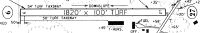
| Runways: | 09/27 |
| Longest Runway: | 09/27 is 1821 ft (555 m) long |
| Runways with an Instrument Approach: |
8G8 Airport Runway Details
| Runway 09/27 | 1821 ft x 100 ft (555 m x 30 m) | |
| Runway Length Source: | STATE as of 06/21/2023 | |
| Surface: | Turf - Good condition - No special surface treatment | |
Runway 09 |
Runway 27 |
|
Elevation: |
1317.7 | 1326.9 |
Latitude: |
40-52-58.0616N | 40-52-57.3368N |
Longitude: |
080-53-03.5243W | 080-52-39.8388W |
|
Runway True Alignment: |
092 | 272 |
Glide Path Angle: |
0.0 degrees | 0.0 degrees |
Traffic Pattern: |
Left | Right |
Object at End: |
TREE | TREES |
Object Height: |
33 | 90 |
Distance from End: |
406 | 101 |
Object Centerline Offset: |
54 ft. left of centerline | 110 ft. left of centerline |
REIL: |
No | No |
Touchdown Lights: |
No | No |
Centerline Lights: |
No | No |
Services
Airframe Repair: |
Major |
Powerplant Repair: |
Major |
Bottled Oxygen: |
None |
Bulk Oxygen: |
None |
Fuel Available: |
100LL, Jet A-1+ |
Landing Fees: |
No |
Parking: |
Hangars and tiedowns available |
Maps & Diagrams
8G8 Sectional
Flight Planning
at skyvector.com
at skyvector.com