Location
Latitude: |
36-20-37.0000N (36.343611) |
Longitude: |
094-26-41.4000W (-94.444833) |
Elevation: |
1177.8 feet MSL (359 m MSL) |
Magnetic Variation: |
1.2 E (as of April 2024 from WMM2020 model) |
Time Zone: |
UTC -6.0 (Standard Time) UTC -5.0 (Daylight Savings Time) |
From City: |
02 N.M. NE of Decatur, Arkansas |
Found On: |
Kansas City Chart |
FAA Region: |
ASW |
Contacts
Manager: |
Privately owned: |
| LANCE DIXON 18820 CRYSTAL LAKE ROAD DECATUR, AR 72722 479-220-5047 |
CRYSTAL LAKE FLY-IN COMMUNITY, LLC 33801 KANIS ROAD PARON, AR 72122 501-351-4545 |
Operations
Airport Status: |
Operational |
Facility Use: |
Public |
Type: |
Airport |
Activation Date: |
11/1955 |
Control tower: |
No |
Attendance (Months/Days/Hours): |
Months/Days/Hours Unattended |
Boundary ARTCC: |
ZME (Memphis) |
Responsible ARTCC: |
ZME (Memphis) |
Lighting Schedule: |
SS-SR |
Segmented Circle Indicator: |
No |
Traffic Pattern Altitude (MSL): |
2178 feet (664 m) |
NOTAMs Facility: |
JBR |
NOTAM-D Service: |
Yes |
International Airport of Entry: |
No |
Customs Landing Rights: |
No |
Military Landing Rights: |
No |
Civil/Military Joint Use: |
No |
Based Aircraft
| Single Engine: | 11 |
| GA Helicopters: | 3 |
Annual Operations (as of 03/31/2021)
| Total Operations: | 1700 | |
| GA Local: | 1200 | 70.6% |
| GA Itinerant: | 500 | 29.4% |
Communications
| CTAF: | 122.800 |
| Unicom: | 122.800 |
| Approach: | RAZORBACK 121.0 121.0 121.0 MEMPHIS ARTCC |
| Departure: | RAZORBACK 121.0 121.0 121.0 MEMPHIS ARTCC |
- APCH/DEP SVC PRVDD BY MEMPHIS ARTCC ON FREQS 126.1/269.0 (FAYETTEVILLE RCAG) WHEN RAZORBACK APCH CTL CLSD.
Fixed Based Operators (FBOs) & Fuel
(Click on a business for detail)
Please help us keep this information up to date. This is a FREE SERVICE just like everything else on Airport Guide! If you see that a business needs to be added, modified, or deleted please fill out our Update Form.
To add, modify, or delete a business click here.
Please help us keep this information up to date. This is a FREE SERVICE just like everything else on Airport Guide! If you see that a business needs to be added, modified, or deleted please fill out our Update Form.
Area Code: 501 |
| Business Name | Frequency | Phone | Fuel Grade |
|---|
Flight Service Stations
| Primary | Alternate | |
| FSS on Field: | N | |
| FSS Name (ID): | Jonesboro(JBR) | |
| Frequency: | ||
| Toll Free Phone: | 1-800-WX-BRIEF |
Instrument Procedures / Charts
FAA Terminal Procedures valid from 0901Z 03/21/24 to 0901Z 04/18/24.
There are various types of charts available for an airport. They are listed in the Page Type column. Here is a legend for those types:
APD - Airport Diagram
DP - Departure Procedure Charts
HOT - Hot Spots
IAP - Instrument Approach Procedure Charts
MIN - Minimums
STAR - Standard Terminal Arrival Charts
| Page Type | Page Name | Volume | Action Since Last Cycle |
|---|---|---|---|
| IAP | RNAV (GPS) RWY 13 | SC-1 | |
| MIN | TAKEOFF MINIMUMS | SC-1 |
Terminal Procedures are only available for airports in several countries with more being added all the time. If you are looking for a specific country's charts, please send an email to support(at)airportguide.com stating the country name. This will be used to prioritize the implementation.
Navigation Aids (Navaids) near 5M5
| Dist (NM) | ID | Morse Code | Name | Type | Freq | True Hdg | Mag Hdg |
|---|---|---|---|---|---|---|---|
| 9.5 | SLG | . . . . _ . . _ _ . | Siloam Springs | NDB | 284 | 192 | 191 |
| 16.7 | RZC | . _ . _ _ . . _ . _ . | Razorback | VORTAC | 116.40 | 110 | 109 |
| 19.5 | RO | . _ . _ _ _ | Rogrs | NDB | 263 | 68 | 67 |
| 21.7 | DAK | _ . . . _ _ . _ | Drake | DME | 115.25 | 146 | 145 |
| 29.9 | EOS | . _ _ _ . . . | Neosho | DME | 117.3 | 0 | 359 |
| 36.9 | TQH | _ _ _ . _ . . . . | Tahlequah | NDB | 215 | 227 | 226 |
| 51.9 | JL | . _ _ _ . _ . . | Lunns | NDB | 344 | 353 | 352 |
| 57.9 | FSM | . . _ . . . . _ _ | Fort Smith | VORTAC | 110.40 | 171 | 170 |
| 59.2 | IQS | . . _ _ . _ . . . | Sallisaw | NDB | 520 | 196 | 195 |
| 59.5 | HRO | . . . . . _ . _ _ _ | Harrison | VOR-DME | 112.50 | 91 | 90 |
| 60.4 | FS | . . _ . . . . | Wizer | NDB | 223 | 169 | 168 |
| 61.0 | OSW | _ _ _ . . . . _ _ | Oswego | DME | 117.6 | 323 | 322 |
| 61.3 | GK | _ _ . _ . _ | Jembo | NDB | 311 | 181 | 180 |
| 62.8 | HR | . . . . . _ . | Bakky | NDB | 395 | 97 | 96 |
| 65.6 | TUL | _ . . _ . _ . . | Tulsa | VORTAC | 114.40 | 262 | 260 |
| 67.3 | PTS | . _ _ . _ . . . | Pittsburg | NDB | 365 | 348 | 347 |
| 69.0 | LLU | . _ . . . _ . . . . _ | Spring River | NDB | 356 | 5 | 4 |
| 70.1 | TUL | _ . . _ . _ . . | Tulsa Intl | VOT | 109.00 | 263 | 261 |
| 70.4 | CFV | _ . _ . . . _ . . . . _ | Coffeyville | NDB | 212 | 310 | 308 |
| 71.4 | TU | _ . . _ | Oillr | NDB | 338 | 258 | 256 |
Nearby Airports with Fuel
Notices to Airmen (NOTAMS)
Remarks
| A110-1 | BE ALERT FOR +176 FT TWR APRXLY 1300 FT N OF RY 13. |
| A110-3 | DEER & GEESE ON & INVOF ARPT. |
| A110-4 | FOR CD CTC RAZORBACK APCH 479-649-2416, WHEN APCH CLSD CTC MEMPHIS ARTCC AT 901-368-8453/8449. |
| A42-13 | NSTD THLD MARKINGS DUE TO SIZE. |
| A42-31 | NSTD THLD MARKNIGS DUE TO SIZE. |
| A43-13 | VASI OTS INDEFLY. |
| A43-31 | VASI OTS INDEFLY. |
| E111 | PRE DATES THE ACT. |
Runways
Runway Summary
| Runways: | 13/31 |
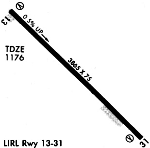
| Longest Runway: | 13/31 is 3863 ft (1177 m) long |
| Runways with an Instrument Approach: |
5M5 Airport Runway Details
| Runway 13/31 | 3863 ft x 75 ft (1177 m x 23 m) | |
| Runway Length Source: | 3RD PARTY SURVEY as of 08/04/2011 | |
| Surface: | Asphalt - Fair condition - No special surface treatment | |
| Runway Edge Lights: | Low Intensity | |
Runway Weight Bearing Capacity (in thousands of pounds) |
||
| Single Wheel Landing Gear: | 10.0 | |
Runway 13 |
Runway 31 |
|
Elevation: |
1154.0 | 1176.4 |
Latitude: |
36-20-50.4447N | 36-20-23.5970N |
Longitude: |
094-26-58.1713W | 094-26-24.5924W |
|
Runway True Alignment: |
134 | 314 |
Glide Path Angle: |
3.5 degrees | 3.5 degrees |
Traffic Pattern: |
Left | Left |
Runway Markings Type: |
Nonprecision Instrument | Nonprecision Instrument |
Runway Markings Condition: |
Fair | Fair |
Object at End: |
TREES | TREES |
Object Height: |
55 | 41 |
Distance from End: |
450 | 300 |
Object Centerline Offset: |
185 ft. right of centerline | 125 ft. left of centerline |
Visual Glide Slope Indicators: |
2-Box VASI On Left Side Of Runway | 2-Box VASI On Left Side Of Runway |
Threshold Crossing Height: |
53 | 37 |
Services
Bottled Oxygen: |
None |
Bulk Oxygen: |
None |
Fuel Available: |
100LL |
Landing Fees: |
No |
Parking: |
Tiedowns available |
Maps & Diagrams
5M5 Sectional
Flight Planning
at skyvector.com
at skyvector.com