Location
Latitude: |
40-24-28.7150N (40.407976) |
Longitude: |
083-13-09.6960W (-83.21936) |
Elevation: |
918.0 feet MSL (280 m MSL) |
Magnetic Variation: |
7.1 W (as of April 2024 from WMM2020 model) |
Time Zone: |
UTC -5.0 (Standard Time) UTC -4.0 (Daylight Savings Time) |
From City: |
03 N.M. NW of Radnor, Ohio |
Found On: |
Detroit Chart |
FAA Region: |
AGL |
Contacts
Manager: |
Privately owned: |
| LINDA SUE PACKER 5266 MOONEY RD RADNOR, OH 43066-9710 740-494-2554 |
RICHARD L PACKER 5266 MOONEY RD RADNOR, OH 43066-9710 740-494-2554 |
Operations
Airport Status: |
Operational |
Facility Use: |
Public |
Type: |
Airport |
Activation Date: |
03/1976 |
Control tower: |
No |
Attendance (Months/Days/Hours): |
Months/Days/Hours ALL/ALL/ALL |
Boundary ARTCC: |
ZID (Indianapolis) |
Responsible ARTCC: |
ZID (Indianapolis) |
Segmented Circle Indicator: |
No |
Traffic Pattern Altitude (MSL): |
1918 feet (585 m) |
NOTAMs Facility: |
DAY |
NOTAM-D Service: |
Yes |
International Airport of Entry: |
No |
Customs Landing Rights: |
No |
Based Aircraft
| Single Engine: | 20 |
Annual Operations (as of 08/17/2022)
| Total Operations: | 3175 | |
| GA Local: | 2950 | 92.9% |
| GA Itinerant: | 225 | 7.1% |
Communications
| CTAF: | 122.900 |
Fixed Based Operators (FBOs) & Fuel
(Click on a business for detail)
Please help us keep this information up to date. This is a FREE SERVICE just like everything else on Airport Guide! If you see that a business needs to be added, modified, or deleted please fill out our Update Form.
To add, modify, or delete a business click here.
Please help us keep this information up to date. This is a FREE SERVICE just like everything else on Airport Guide! If you see that a business needs to be added, modified, or deleted please fill out our Update Form.
Area Code: 740 |
| Business Name | Frequency | Phone | Fuel Grade |
|---|
Flight Service Stations
| Primary | Alternate | |
| FSS on Field: | N | |
| FSS Name (ID): | Dayton(DAY) | |
| Frequency: | ||
| Toll Free Phone: | 1-800-WX-BRIEF |
Instrument Procedures / Charts
Terminal Procedures are only available for airports in several countries with more being added all the time. If you are looking for a specific country's charts, please send an email to support(at)airportguide.com stating the country name. This will be used to prioritize the implementation.
Navigation Aids (Navaids) near 5E9
| Dist (NM) | ID | Morse Code | Name | Type | Freq | True Hdg | Mag Hdg |
|---|---|---|---|---|---|---|---|
| 14.4 | BUD | _ . . . . . _ _ . . | Buckeye | VOR | 109.80 | 29 | 36 |
| 20.1 | OS | _ _ _ . . . | Fuler | NDB | 515 | 177 | 184 |
| 20.7 | RUV | . _ . . . _ . . . _ | Rushsylvania | NDB | 326 | 278 | 285 |
| 25.4 | CHC | _ . _ . . . . . _ . _ . | Grens | NDB | 272 | 159 | 166 |
| 29.1 | CMH | _ . _ . _ _ . . . . | Port Columbus | VOT | 111.00 | 148 | 155 |
| 32.7 | APE | . _ . _ _ . . | Appleton | VORTAC | 116.70 | 117 | 124 |
| 33.1 | CM | _ . _ . _ _ | Sumie | NDB | 391 | 139 | 146 |
| 35.3 | BU | _ . . . . . _ | Boutn | NDB | 230 | 178 | 185 |
| 36.2 | LC | . _ . . _ . _ . | Pickl | NDB | 376 | 150 | 157 |
| 38.4 | ROD | . _ . _ _ _ _ . . | Rosewood | VORTAC | 117.50 | 259 | 266 |
| 38.4 | LCK | . _ . . _ . _ . _ . _ | Rickenbacker | TACAN | 69X | 159 | 166 |
| 38.6 | AOH | . _ _ _ _ . . . . | Allen County | VOR | 108.40 | 297 | 304 |
| 39.8 | MFD | _ _ . . _ . _ . . | Mansfield | VORTAC | 108.80 | 45 | 52 |
| 40.9 | FBC | . . _ . _ . . . _ . _ . | Flag City | VORTAC | 108.20 | 323 | 330 |
| 40.9 | DD | _ . . _ . . | Cobbs | NDB | 253 | 167 | 174 |
| 41.1 | CCJ | _ . _ . _ . _ . . _ _ _ | Clark County | NDB | 341 | 218 | 225 |
| 41.2 | TII | _ . . . . | Tiffin | NDB | 269 | 0 | 7 |
| 41.3 | MF | _ _ . . _ . | Manns | NDB | 372 | 58 | 65 |
| 41.5 | HEH | . . . . . . . . . | Newark | NDB | 524 | 123 | 130 |
| 42.1 | BNR | _ . . . _ . . _ . | Benton Ridge | NDB | 334 | 331 | 338 |
Nearby Airports with Fuel
Notices to Airmen (NOTAMS)
Remarks
| A110-1 | FOR CD CTC COLUMBUS APCH AT 614-338-8537. |
| A110-2 | DEER & BIRDS ON & INVOF ARPT. |
| A17 | OWNER LIVES ADJ. |
| A42-09 | ORANGE TFC CONES. |
| A42-27 | ORANGE TFC CONES. |
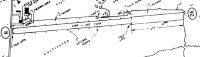
| E111 | PRVDD RWY THRS ARE LCTD SO AS TO PRVD A MNM 20:1 OBSTN CLNC OVR ANY OBSTS (MOONEY ROAD CSDRD A 15 FT OBST). |
Runways
Runway Summary
| Runways: | 09/27 |
| Longest Runway: | 09/27 is 3470 ft (1058 m) long |
| Runways with an Instrument Approach: |
5E9 Airport Runway Details
| Runway 09/27 | 3470 ft x 90 ft (1058 m x 27 m) | |
| Surface: | Turf - Excellent condition - No special surface treatment | |
Runway 09 |
Runway 27 |
|
Glide Path Angle: |
0.0 degrees | 0.0 degrees |
Object at End: |
TREES | |
Object Height: |
75 | |
Distance from End: |
0 | |
Object Centerline Offset: |
105 ft. right of centerline | |
Displaced Threshold: |
120 |
Services
Airframe Repair: |
Major |
Powerplant Repair: |
Major |
Bottled Oxygen: |
None |
Bulk Oxygen: |
High Pressure / Low Pressure |
Fuel Available: |
100LL, Jet A-1, Jet A-1+ |
Landing Fees: |
No |
Parking: |
Hangars available |
Maps & Diagrams
5E9 Sectional
Flight Planning
at skyvector.com
at skyvector.com