Location
Latitude: |
40-06-25.2510N (40.107014) |
Longitude: |
080-58-31.3440W (-80.975373) |
Elevation: |
1100.0 feet MSL (335 m MSL) |
Magnetic Variation: |
8.6 W (as of April 2024 from WMM2020 model) |
Time Zone: |
UTC -5.0 (Standard Time) UTC -4.0 (Daylight Savings Time) |
From City: |
00 N.M. N of Bannock, Ohio |
Found On: |
Detroit Chart |
FAA Region: |
AGL |
Contacts
Manager: |
Privately owned: |
| MARK WESTLAKE 70245 BANNOCK UNIONTOWN RD SAINT CLAIRSVILLE, OH 43950-9600 740-391-5925 |
OHIO RIVER COLLIERIES CO 70245 BANNOCK UNIONTOWN RD SAINT CLAIRSVILLE, OH 43950-9600 740-391-5925 |
Operations
Airport Status: |
Operational |
Facility Use: |
Public |
Type: |
Heliport |
Activation Date: |
09/1975 |
Control tower: |
No |
Attendance (Months/Days/Hours): |
Months/Days/Hours ALL/MON-FRI/0800-1600 |
Boundary ARTCC: |
ZOB (Cleveland) |
Responsible ARTCC: |
ZOB (Cleveland) |
Segmented Circle Indicator: |
No |
Traffic Pattern Altitude (MSL): |
2100 feet (640 m) |
NOTAMs Facility: |
CLE |
NOTAM-D Service: |
Yes |
Based Aircraft
Annual Operations (as of 09/06/2022)
| Total Operations: | 24 | |
| GA Itinerant: | 24 | 100.0% |
Communications
| CTAF: | 122.900 |
- APCH/DEP SVC PRVDD BY CLEVELAND ARTCC (ZOB) 126.95/239.3 (BELMONT RCAG).
Fixed Based Operators (FBOs) & Fuel
(Click on a business for detail)
Please help us keep this information up to date. This is a FREE SERVICE just like everything else on Airport Guide! If you see that a business needs to be added, modified, or deleted please fill out our Update Form.
To add, modify, or delete a business click here.
Please help us keep this information up to date. This is a FREE SERVICE just like everything else on Airport Guide! If you see that a business needs to be added, modified, or deleted please fill out our Update Form.
Area Code: 740 |
| Business Name | Frequency | Phone | Fuel Grade |
|---|
Flight Service Stations
| Primary | Alternate | |
| FSS on Field: | N | |
| FSS Name (ID): | Cleveland(CLE) | |
| Frequency: | ||
| Toll Free Phone: | 1-800-WX-BRIEF |
Instrument Procedures / Charts
Terminal Procedures are only available for airports in several countries with more being added all the time. If you are looking for a specific country's charts, please send an email to support(at)airportguide.com stating the country name. This will be used to prioritize the implementation.
Navigation Aids (Navaids) near 2D6
| Dist (NM) | ID | Morse Code | Name | Type | Freq | True Hdg | Mag Hdg |
|---|---|---|---|---|---|---|---|
| 8.0 | CFX | _ . _ . . . _ . _ . . _ | Cadiz | NDB | 239 | 347 | 356 |
| 9.1 | AIR | . _ . . . _ . | Bellaire | VOR-DME | 117.10 | 126 | 135 |
| 20.8 | HLG | . . . . . _ . . _ _ . | Wheeling | VOR-DME | 114.25 | 63 | 72 |
| 24.1 | CTW | _ . _ . _ . _ _ | Newcomerstown | DME | 111.8 | 287 | 295 |
| 42.4 | MMJ | _ _ _ _ . _ _ _ | Montour | DME | 112 | 57 | 66 |
| 43.3 | ZZV | _ _ . . _ _ . . . . . _ | Zanesville | VOR-DME | 114.95 | 256 | 264 |
| 43.4 | BSV | _ . . . . . . . . . _ | Briggs | VOR-DME | 112.40 | 331 | 340 |
| 44.0 | JPU | . _ _ _ . _ _ . . . _ | Parkersburg | VOR-DME | 114.45 | 204 | 212 |
| 44.0 | AGC | . _ _ _ . _ . _ . | Allegheny | VOR-DME | 110.00 | 76 | 85 |
| 45.0 | HRA | . . . . . _ . . _ | Zanesville | NDB | 204 | 254 | 262 |
| 47.8 | PKB | . _ _ . _ . _ _ . . . | Marietta Ohio | FAN MARKER | 205 | 213 | |
| 48.6 | MLR | _ _ . _ . . . _ . | Millersburg/Dcmsnd | NDB | 382 | 302 | 310 |
| 53.0 | CAK | _ . _ . . _ _ . _ | Akron/Canton Regional | VOT | 110.60 | 336 | 345 |
| 55.4 | EWC | . . _ _ _ . _ . | Ellwood City | VOR-DME | 115.80 | 38 | 47 |
| 56.3 | PK | . _ _ . _ . _ | Versi | NDB | 388 | 204 | 212 |
| 56.7 | MKP | _ _ _ . _ . _ _ . | Mc Keesport | NDB | 287 | 74 | 83 |
| 58.1 | VV | . . . _ . . . _ | Camor | NDB | 299 | 102 | 111 |
| 60.6 | UCP | . . _ _ . _ . . _ _ . | Castle | NDB | 272 | 24 | 33 |
| 60.7 | AK | . _ _ . _ | Akron | NDB | 362 | 342 | 351 |
| 60.8 | CKB | _ . _ . _ . _ _ . . . | Clarksburg | VOR-DME | 112.60 | 147 | 156 |
Nearby Airports with Fuel
Notices to Airmen (NOTAMS)
Remarks
| A110-2 | FOR CD CTC CLEVELAND ARTCC AT 440-774-0226/0490. |
| A14 | MARK@ORCPROPERTIES.COM. |
| A16 | OR 740-968-3504. |
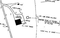
| A52-H1 | 35 FT POLES, 66 FT NW; 35 FT PLINE, 240 FT NW. |
| A58-H1 | TREES & BRUSH NW OF HELIPAD. |
| E111 | PRVDD INGRESS/EGRESS 195-190 DEGS CLKWS USING PAD AS CNTR OF A COMPASS ROSE. |
Runways
Runway Summary
| Runways: | H1 |
| Longest Runway: | H1 is 20 ft (6 m) long |
| Runways with an Instrument Approach: |
2D6 Airport Runway Details
| Helipad H1 | 20 ft x 20 ft (6 m x 6 m) | |
| Surface: | Concrete - Good condition - No special surface treatment | |
Helipad H1 |
||
Elevation: |
1100.0 | |
Latitude: |
40-06-25.2510N | |
Longitude: |
080-58-31.3440W | |
Glide Path Angle: |
0.0 degrees | 0.0 degrees |
Runway Markings Condition: |
Good |
Services
Airframe Repair: |
None |
Powerplant Repair: |
None |
Bottled Oxygen: |
None |
Bulk Oxygen: |
None |
Fuel Available: |
100LL |
Landing Fees: |
No |
Parking: |
Tiedowns available |
Other Services: |
Parachute rental |
Maps & Diagrams
2D6 Sectional
Flight Planning
at skyvector.com
at skyvector.com