Location
Latitude: |
46-10-23.8660N (46.173296) |
Longitude: |
098-04-48.1390W (-98.080039) |
Elevation: |
1334.9 feet MSL (407 m MSL) |
Magnetic Variation: |
3.6 E (as of April 2024 from WMM2020 model) |
Time Zone: |
UTC -6.0 (Standard Time) UTC -5.0 (Daylight Savings Time) |
From City: |
02 N.M. N of Oakes, North Dakota |
Found On: |
Twin Cities Chart |
FAA Region: |
AGL |
Contacts
Manager: |
Publicly owned: |
| TRAVIS MCPHERSON 8550 HWY 1 OAKES, ND 58474 701-710-1220 |
OAKES ARPT AUTH 115 SOUTH 5TH ST OAKES, ND 58474 701-742-2137 |
Operations
Airport Status: |
Operational |
Facility Use: |
Public |
Type: |
Airport |
Activation Date: |
09/1981 |
Control tower: |
No |
Attendance (Months/Days/Hours): |
Months/Days/Hours MAY-OCT/MON-SAT/0800-1700 |
Boundary ARTCC: |
ZMP (Minneapolis) |
Responsible ARTCC: |
ZMP (Minneapolis) |
Lighting Schedule: |
SEE RMK |
Segmented Circle Indicator: |
Yes |
Traffic Pattern Altitude (MSL): |
2335 feet (712 m) |
NOTAMs Facility: |
GFK |
NOTAM-D Service: |
Yes |
Military Landing Rights: |
Yes |
Based Aircraft
| Single Engine: | 9 |
Annual Operations (as of 05/20/2019)
| Total Operations: | 8350 | |
| Air Taxi: | 300 | 3.6% |
| GA Local: | 5000 | 59.9% |
| GA Itinerant: | 3000 | 35.9% |
| Military Aircraft: | 50 | 0.6% |
Communications
| CTAF: | 122.900 |
| AWOS-3: | 118.675 (701-742-3991) |
- APCH/DEP SVC PRVDD BY MINNEAPOLIS ARTCC ON FREQS 124.2/270.3 (WOODWORTH RCAG).
Fixed Based Operators (FBOs) & Fuel
(Click on a business for detail)
Please help us keep this information up to date. This is a FREE SERVICE just like everything else on Airport Guide! If you see that a business needs to be added, modified, or deleted please fill out our Update Form.
To add, modify, or delete a business click here.
Please help us keep this information up to date. This is a FREE SERVICE just like everything else on Airport Guide! If you see that a business needs to be added, modified, or deleted please fill out our Update Form.
Area Code: 701 |
| Business Name | Frequency | Phone | Fuel Grade |
|---|---|---|---|
| Widmer Flying Service
Update FBO info |
742-3145, -2293 | 100LL |
Flight Service Stations
| Primary | Alternate | |
| FSS on Field: | N | |
| FSS Name (ID): | Grand Forks(GFK) | |
| Frequency: | ||
| Toll Free Phone: | 1-800-WX-BRIEF |
Instrument Procedures / Charts
FAA Terminal Procedures valid from 0901Z 03/21/24 to 0901Z 04/18/24.
There are various types of charts available for an airport. They are listed in the Page Type column. Here is a legend for those types:
APD - Airport Diagram
DP - Departure Procedure Charts
HOT - Hot Spots
IAP - Instrument Approach Procedure Charts
MIN - Minimums
STAR - Standard Terminal Arrival Charts
| Page Type | Page Name | Volume | Action Since Last Cycle |
|---|---|---|---|
| IAP | RNAV (GPS) RWY 30 | NC-1 | |
| MIN | TAKEOFF MINIMUMS | NC-1 |
Terminal Procedures are only available for airports in several countries with more being added all the time. If you are looking for a specific country's charts, please send an email to support(at)airportguide.com stating the country name. This will be used to prioritize the implementation.
Navigation Aids (Navaids) near 2D5
| Dist (NM) | ID | Morse Code | Name | Type | Freq | True Hdg | Mag Hdg |
|---|---|---|---|---|---|---|---|
| 18.4 | GWR | _ _ . . _ _ . _ . | Gwinner | NDB | 278 | 80 | 77 |
| 46.2 | JM | . _ _ _ _ _ | Sabon | NDB | 395 | 333 | 329 |
| 46.9 | ABR | . _ _ . . . . _ . | Aberdeen | VOR-DME | 113.00 | 195 | 191 |
| 48.4 | AB | . _ _ . . . | Reney | NDB | 203 | 192 | 188 |
| 51.8 | JMS | . _ _ _ _ _ . . . | Jamestown | VOR-DME | 114.50 | 331 | 327 |
| 61.5 | BWP | _ . . . . _ _ . _ _ . | Breckenridge-Wahpeton | NDB | 233 | 85 | 82 |
| 61.6 | FAR | . . _ . . _ . _ . | Fargo | VOR-DME | 116.20 | 55 | 52 |
| 68.1 | ETH | . _ . . . . | Wheaton | NDB | 326 | 109 | 106 |
| 72.3 | AA | . _ . _ | Kenie | NDB | 365 | 45 | 42 |
| 80.1 | FFM | . . _ . . . _ . _ _ | Fergus Falls | VOR-DME | 110.40 | 84 | 81 |
| 81.7 | ATY | . _ _ _ . _ _ | Watertown | TACAN | 116.60 | 150 | 147 |
| 84.0 | FF | . . _ . . . _ . | Hamre | NDB | 337 | 87 | 84 |
| 87.0 | VVV | . . . _ . . . _ . . . _ | Ortonville | NDB | 332 | 126 | 123 |
| 91.0 | AT | . _ _ | Lican | NDB | 215 | 154 | 151 |
| 95.4 | MOX | _ _ _ _ _ _ . . _ | Morris | VOR-DME | 109.60 | 111 | 108 |
| 98.7 | DTL | _ . . _ . _ . . | Detroit Lakes | VOR-DME | 111.20 | 65 | 62 |
Nearby Airports with Fuel
Notices to Airmen (NOTAMS)
Remarks
| A110-2 | CFM ARPT CONDS WINTER MONTHS BFR USE CALL 701-710-1220. |
| A110-4 | RWY 17/35 CLSD WINTER MONTHS NO SNOW REMOVAL. |
| A110-5 | FBO HRS MON-FRI 0800-1700 FREQ 122.9. |
| A110-6 | FOR CD CTC MINNEAPOLIS ARTCC AT 651-463-5588. |
| A13 | ARPT AUTHORITY CLERK. |
| A16 | ADL CONTACT GARY SCHNELL 701-678-4910. |
| A17 | ON CALL AFT HRS 701-710-1220. |
| A52-12 | MOBILE IRRIGATOR INTMTLY IN APCH L & R OF CNTRLN. |
| A70-FUEL-10 | 0LL FOR FUEL CALL 701-710-1220 OR 701-678-4910 OR 701-210-1054. |
| A81-APT | ACTVT MIRL RY 12/30 & PAPI RYS 12 & 30 - CTAF. |
Runways
Runway Summary
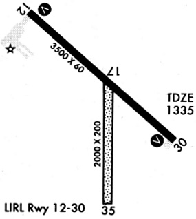
| Runways: | 12/30 17/35 H1 |
| Longest Runway: | 12/30 is 3505 ft (1068 m) long |
| Runways with an Instrument Approach: |
2D5 Airport Runway Details
| Runway 12/30 | 3505 ft x 60 ft (1068 m x 18 m) | |
| Runway Length Source: | NGS as of 05/21/1992 | |
| Surface: | Asphalt - Good condition - No special surface treatment | |
| Runway Edge Lights: | Medium Intensity | |
Runway Weight Bearing Capacity (in thousands of pounds) |
||
| Single Wheel Landing Gear: | 12.5 | |
Runway 12 |
Runway 30 |
|
Elevation: |
1330.4 | 1334.9 |
Latitude: |
46-10-38.9140N | 46-10-16.0000N |
Longitude: |
098-05-07.6930W | 098-04-30.3770W |
|
Runway True Alignment: |
131 | 311 |
Glide Path Angle: |
3.0 degrees | 3.0 degrees |
Runway Markings Type: |
Nonprecision Instrument | Nonprecision Instrument |
Runway Markings Condition: |
Fair | Fair |
Object at End: |
OTHER | |
Object Height: |
14 | |
Distance from End: |
300 | |
Object Centerline Offset: |
265 ft. left of centerline | |
Visual Glide Slope Indicators: |
2-Light PAPI On Left Side Of Runway | 2-Light PAPI On Left Side Of Runway |
Threshold Crossing Height: |
27 | 27 |
| Runway 17/35 | 2001 ft x 120 ft (610 m x 37 m) | |
| Runway Length Source: | ADO as of 01/18/2017 | |
| Surface: | Asphalt - Good condition - No special surface treatment | |
Runway 17 |
Runway 35 |
|
Elevation: |
1333.5 | 1332.7 |
Latitude: |
46-10-27.4500N | 46-10-07.7000N |
Longitude: |
098-04-46.5500W | 098-04-46.5900W |
|
Runway True Alignment: |
180 | 000 |
Glide Path Angle: |
0.0 degrees | 0.0 degrees |
Runway Markings Type: |
None | None |
Object Centerline Offset: |
265 ft. left of centerline |
| Helipad H1 | 60 ft x 60 ft (18 m x 18 m) | |
| Runway Length Source: | STATE as of 01/23/2017 | |
| Surface: | Asphalt - Good condition - No special surface treatment | |
Helipad H1 |
||
Elevation: |
1322.0 | |
Latitude: |
46-10-34.3500N | |
Longitude: |
098-05-17.5500W | |
Glide Path Angle: |
0.0 degrees | 0.0 degrees |
Runway Markings Type: |
Basic | |
Runway Markings Condition: |
Fair | |
Object Centerline Offset: |
265 ft. left of centerline |
Services
Airframe Repair: |
Major |
Powerplant Repair: |
Major |
Bottled Oxygen: |
None |
Bulk Oxygen: |
None |
Fuel Available: |
100LL, Jet A |
Landing Fees: |
No |
Parking: |
Hangars and tiedowns available |
Maps & Diagrams
2D5 Sectional
Flight Planning
at skyvector.com
at skyvector.com