Location
Latitude: |
46-16-16.1428N (46.271151) |
Longitude: |
106-37-26.0476W (-106.623902) |
Elevation: |
2729.3 feet MSL (832 m MSL) |
Magnetic Variation: |
9.2 E (as of April 2024 from WMM2020 model) |
Time Zone: |
UTC -7.0 (Standard Time) UTC -6.0 (Daylight Savings Time) |
From City: |
03 N.M. E of Forsyth, Montana |
Found On: |
Billings Chart |
FAA Region: |
ANM |
Contacts
Manager: |
Publicly owned: |
| BRIAN SCHWEND PO BOX 45 FORSYTH, MT 59327 406-346-7129 |
COUNTY OF ROSEBUD P.O. BOX 47 FORSYTH, MT 59327 (406) 346-2251 |
Operations
Airport Status: |
Operational |
Facility Use: |
Public |
Type: |
Airport |
Activation Date: |
09/1943 |
Control tower: |
No |
Attendance (Months/Days/Hours): |
Months/Days/Hours IREG |
Boundary ARTCC: |
ZLC (Salt Lake City) |
Responsible ARTCC: |
ZLC (Salt Lake City) |
Lighting Schedule: |
SEE RMK |
Segmented Circle Indicator: |
Yes |
Traffic Pattern Altitude (MSL): |
3729 feet (1137 m) |
NOTAMs Facility: |
GTF |
NOTAM-D Service: |
Yes |
International Airport of Entry: |
No |
Customs Landing Rights: |
No |
Military Landing Rights: |
Yes |
Civil/Military Joint Use: |
No |
Based Aircraft
| Single Engine: | 20 |
Annual Operations (as of 07/31/2022)
| Total Operations: | 8170 | |
| Air Taxi: | 325 | 4.0% |
| GA Local: | 4825 | 59.1% |
| GA Itinerant: | 2995 | 36.7% |
| Military Aircraft: | 25 | 0.3% |
Communications
| CTAF: | 122.800 |
| Unicom: | 122.800 |
| AWOS-AV: | 122.8 (406-346-2571) |
- COMMUNICATIONS PRVDD BY GREAT FALLS RADIO ON 122.2 (MILES CITY RCO).
- APCH/DEP CTL SVC PRVDD BY SALT LAKE ARTCC (ZLC) ON 126.85/305.2 (MILES CITY RCAG).
Fixed Based Operators (FBOs) & Fuel
(Click on a business for detail)
Please help us keep this information up to date. This is a FREE SERVICE just like everything else on Airport Guide! If you see that a business needs to be added, modified, or deleted please fill out our Update Form.
To add, modify, or delete a business click here.
Please help us keep this information up to date. This is a FREE SERVICE just like everything else on Airport Guide! If you see that a business needs to be added, modified, or deleted please fill out our Update Form.
Area Code: 406 |
| Business Name | Frequency | Phone | Fuel Grade |
|---|---|---|---|
| Forsyth Aviation
Update FBO info |
356-2571 | ||
| Schwend Aviation
Update FBO info |
Unicom 122.8 | 356-7129 |
Flight Service Stations
| Primary | Alternate | |
| FSS on Field: | N | |
| FSS Name (ID): | Great Falls(GTF) | |
| Frequency: | ||
| Toll Free Phone: | 1-800-WX-BRIEF |
Instrument Procedures / Charts
FAA Terminal Procedures valid from 0901Z 03/21/24 to 0901Z 04/18/24.
There are various types of charts available for an airport. They are listed in the Page Type column. Here is a legend for those types:
APD - Airport Diagram
DP - Departure Procedure Charts
HOT - Hot Spots
IAP - Instrument Approach Procedure Charts
MIN - Minimums
STAR - Standard Terminal Arrival Charts
| Page Type | Page Name | Volume | Action Since Last Cycle |
|---|---|---|---|
| IAP | RNAV (GPS) RWY 27 | NW-1 | |
| MIN | TAKEOFF MINIMUMS | NW-1 |
Terminal Procedures are only available for airports in several countries with more being added all the time. If you are looking for a specific country's charts, please send an email to support(at)airportguide.com stating the country name. This will be used to prioritize the implementation.
Navigation Aids (Navaids) near 1S3
| Dist (NM) | ID | Morse Code | Name | Type | Freq | True Hdg | Mag Hdg |
|---|---|---|---|---|---|---|---|
| 4.5 | FOR | . . _ . _ _ _ . _ . | Forsyth | NDB | 236 | 92 | 83 |
| 28.6 | MLS | _ _ . _ . . . . . | Miles City | VOR-DME | 112.10 | 76 | 67 |
| 65.0 | JDN | . _ _ _ _ . . _ . | Jordan | NDB | 263 | 348 | 339 |
| 71.3 | BDX | _ . . . _ . . _ . . _ | Broadus | NDB | 335 | 134 | 125 |
| 80.7 | RPX | . _ . . _ _ . _ . . _ | Roundup | NDB | 362 | 279 | 269 |
| 81.5 | CRR | _ . _ . . _ . . _ . | Circle | NDB | 245 | 31 | 22 |
| 87.7 | SHR | . . . . . . . . _ . | Sheridan | VOR-DME | 113.55 | 192 | 183 |
| 87.8 | BIL | _ . . . . . . _ . . | Billings | VORTAC | 114.50 | 252 | 242 |
| 89.8 | BI | _ . . . . . | Saige | NDB | 251 | 254 | 244 |
| 91.0 | GDV | _ _ . _ . . . . . _ | Glendive | NDB | 410 | 54 | 45 |
| 91.0 | GDV | _ _ . _ . . . . . _ | Glendive | DME | 114.35 | 54 | 45 |
| 98.2 | BKU | _ . . . _ . _ . . _ | Timber | NDB | 344 | 86 | 77 |
Nearby Airports with Fuel
| Dist (NM) | Name (Airport IDs) | True Hdg | Mag Hdg | Fuel Grade |
|---|---|---|---|---|
| 31.9 | Frank Wiley Field Airport (MLS KMLS MLS) |
72 | 63 | 100LL, Jet A |
| 80.4 | Roundup Airport (RPX KRPX RPX) |
279 | 269 | 100LL, Jet A-1 |
| 81.5 | Circle Town County Airport (4U6) |
31 | 22 | 100LL |
| 84.6 | Billings Logan International Airport (BIL KBIL BIL) |
251 | 241 | 100LL, Jet A |
| 91.1 | Dawson Community Airport (GDV KGDV GDV) |
54 | 46 | 100LL, Jet A+ |
| 91.4 | Sheridan County Airport (SHR KSHR SHR) |
189 | 180 | 100, Jet A, Jet A-1+ |
| 95.3 | Laurel Municipal Airport (6S8) |
249 | 239 | 100LL, Jet A |
| 98.2 | Baker Municipal Airport (KBHK BHK) |
86 | 78 | 100LL, Jet A+ |
Notices to Airmen (NOTAMS)
Remarks
| A110-1 | FOR CD CTC SALT LAKE ARTCC AT 801-320-2568. |
| A16 | HOME 406-346-7129. |
| A81-APT | MIRL RY 09/27 OPERS DUSK-2200; AFT 2200 ACTVT - CTAF. ACTVT PAPI RYS 09 & 27 - CTAF. |
Runways
Runway Summary
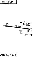
| Runways: | 09/27 |
| Longest Runway: | 09/27 is 4799 ft (1463 m) long |
| Runways with an Instrument Approach: |
1S3 Airport Runway Details
| Runway 09/27 | 4799 ft x 75 ft (1463 m x 23 m) | |
| Runway Length Source: | 3RD PARTY SURVEY as of 07/12/2009 | |
| Surface: | Asphalt - Good condition - No special surface treatment | |
| Runway Edge Lights: | Medium Intensity | |
Runway Weight Bearing Capacity (in thousands of pounds) |
||
| Single Wheel Landing Gear: | 28.0 | |
| Dual Wheel Landing Gear: | 43.5 | |
Runway 09 |
Runway 27 |
|
Elevation: |
2729.3 | 2727.7 |
Latitude: |
46-16-18.8142N | 46-16-13.4713N |
Longitude: |
106-37-59.9781W | 106-36-52.1170W |
|
Runway True Alignment: |
096 | 276 |
Glide Path Angle: |
3.0 degrees | 3.0 degrees |
Traffic Pattern: |
Left | Left |
Runway Markings Type: |
Nonprecision Instrument | Nonprecision Instrument |
Runway Markings Condition: |
Good | Good |
Object Centerline Offset: |
0 ft. left and right of centerline | 0 ft. left and right of centerline |
Visual Glide Slope Indicators: |
2-Light PAPI On Left Side Of Runway | 2-Light PAPI On Left Side Of Runway |
Threshold Crossing Height: |
29 | 29 |
Services
Airframe Repair: |
Major |
Powerplant Repair: |
Major |
Bottled Oxygen: |
None |
Bulk Oxygen: |
None |
Fuel Available: |
100LL, Jet A+ |
Landing Fees: |
No |
Parking: |
Hangars and tiedowns available |
Maps & Diagrams
1S3 Sectional
Flight Planning
at skyvector.com
at skyvector.com