Location
Latitude: |
44-10-53.6000N (44.181556) |
Longitude: |
122-05-08.0000W (-122.085556) |
Elevation: |
1620.0 feet MSL (494 m MSL) |
Magnetic Variation: |
14.4 E (as of April 2024 from WMM2020 model) |
Time Zone: |
UTC -8.0 (Standard Time) UTC -7.0 (Daylight Savings Time) |
From City: |
03 N.M. E of Mc Kenzie Bridge, Oregon |
Found On: |
Klamath Falls Chart |
FAA Region: |
ANM |
Contacts
Manager: |
Publicly owned: |
| ANTHONY BEACH 3040 25TH ST, SE SALEM, OR 97302 503-378-4880 |
OREGON DEPT OF AVIATION 3040 25TH ST, SE SALEM, OR 97302 503-378-4880 |
Operations
Airport Status: |
Operational |
Facility Use: |
Public |
Type: |
Airport |
Activation Date: |
08/1950 |
Control tower: |
No |
Attendance (Months/Days/Hours): |
Months/Days/Hours Unattended |
Boundary ARTCC: |
ZSE (Seattle) |
Responsible ARTCC: |
ZSE (Seattle) |
Segmented Circle Indicator: |
Yes |
Traffic Pattern Altitude (MSL): |
2620 feet (799 m) |
NOTAMs Facility: |
MMV |
NOTAM-D Service: |
Yes |
International Airport of Entry: |
No |
Customs Landing Rights: |
No |
Based Aircraft
Annual Operations (as of 01/15/2019)
| Total Operations: | 400 | |
| GA Itinerant: | 400 | 100.0% |
Communications
| CTAF: | 122.900 |
Fixed Based Operators (FBOs) & Fuel
(Click on a business for detail)
Please help us keep this information up to date. This is a FREE SERVICE just like everything else on Airport Guide! If you see that a business needs to be added, modified, or deleted please fill out our Update Form.
To add, modify, or delete a business click here.
Please help us keep this information up to date. This is a FREE SERVICE just like everything else on Airport Guide! If you see that a business needs to be added, modified, or deleted please fill out our Update Form.
Area Code: 503 |
| Business Name | Frequency | Phone | Fuel Grade |
|---|
Flight Service Stations
| Primary | Alternate | |
| FSS on Field: | N | |
| FSS Name (ID): | Mc Minnville(MMV) | |
| Frequency: | ||
| Toll Free Phone: | 1-800-WX-BRIEF |
Instrument Procedures / Charts
Terminal Procedures are only available for airports in several countries with more being added all the time. If you are looking for a specific country's charts, please send an email to support(at)airportguide.com stating the country name. This will be used to prioritize the implementation.
Navigation Aids (Navaids) near 00S
| Dist (NM) | ID | Morse Code | Name | Type | Freq | True Hdg | Mag Hdg |
|---|---|---|---|---|---|---|---|
| 33.9 | DSD | _ . . . . . _ . . | Deschutes | VORTAC | 117.60 | 82 | 68 |
| 46.5 | RD | . _ . _ . . | Bodey | NDB | 411 | 80 | 66 |
| 48.9 | EU | . . . _ | Frakk | NDB | 260 | 272 | 258 |
| 49.1 | EUG | . . . _ _ _ . | Eugene | VORTAC | 112.90 | 266 | 252 |
| 54.5 | SL | . . . . _ . . | Turno | NDB | 266 | 317 | 302 |
| 55.2 | CVO | _ . _ . . . . _ _ _ _ | Corvallis | VOR-DME | 115.40 | 290 | 275 |
| 57.0 | LWG | . _ . . . _ _ _ _ . | Lewisburg | NDB | 225 | 297 | 282 |
| 79.2 | RBG | . _ . _ . . . _ _ . | Roseburg | NDB | 400 | 224 | 210 |
| 79.9 | UBG | . . _ _ . . . _ _ . | Newberg | VOR-DME | 117.40 | 331 | 316 |
| 81.3 | RBG | . _ . _ . . . _ _ . | Roseburg | VOR-DME | 108.20 | 222 | 208 |
| 83.1 | LBH | . _ . . _ . . . . . . . | Laker | NDB | 332 | 349 | 334 |
| 87.3 | CBU | _ . _ . _ . . . . . _ | Columbia | TACAN | 109.20 | 345 | 330 |
| 87.6 | PDX | . _ _ . _ . . _ . . _ | Portland | VOR-DME | 111.80 | 345 | 330 |
| 87.7 | PDX | . _ _ . _ . . _ . . _ | Portland | VOT | 111.00 | 345 | 330 |
| 87.9 | ONP | _ _ _ _ . . _ _ . | Newport | VORTAC | 117.10 | 286 | 271 |
| 89.4 | HIO | . . . . . . _ _ _ | Hillsboro | VOT | 115.20 | 336 | 321 |
| 96.0 | PND | . _ _ . _ . _ . . | Banks | NDB | 356 | 335 | 320 |
| 96.4 | BTG | _ . . . _ _ _ . | Battle Ground | VORTAC | 116.60 | 347 | 332 |
Nearby Airports with Fuel
Notices to Airmen (NOTAMS)
Remarks
| A110-1 | OWNER ADVISES CTC WITH OR DEPT OF AVIATION (503-378-4880) PRIOR TO USE. |
| A110-10 | SFC CONDS NOT RPRTD. |
| A110-2 | WILDLIFE ON AND INVOF ARPT YEAR ROUND. |
| A110-3 | LAND EAST - TAKEOFF WEST. |
| A110-4 | RY 06/24 SLOPES UP TO THE EAST. |
| A110-5 | +500 FT RIDGELINE PARALLEL TO RY 1000 FT SOUTH. |
| A110-6 | ARPT CLOSED NOV 1- MAY 1. |
| A110-8 | EXPECT SIGNIFICANT TURBULENCE AND DOWNDRAFTS NEAR RY. |
| A110-9 | FOR CD CTC SEATTLE ARTCC AT 253-351-3694. |
| A33-06/24 | RY 06/24 ROUGH ON EAST HALF. |
| A42-06 | RY 06 THLD MARKED WITH WHITE MATS. |
| E111 | ESTABD PRIOR TO 1959. |
Runways
Runway Summary
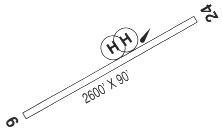
| Runways: | 06/24 |
| Longest Runway: | 06/24 is 2600 ft (792 m) long |
| Runways with an Instrument Approach: |
00S Airport Runway Details
| Runway 06/24 | 2600 ft x 90 ft (792 m x 27 m) | |
| Surface: | Turf - Fair condition - No special surface treatment | |
Runway 06 |
Runway 24 |
|
Elevation: |
1595.0 | 1647.0 |
Latitude: |
44-10-50.8327N | 44-10-56.3274N |
Longitude: |
122-05-25.4024W | 122-04-50.5407W |
|
Runway True Alignment: |
078 | 258 |
Glide Path Angle: |
0.0 degrees | 0.0 degrees |
Traffic Pattern: |
Left | Left |
Runway Markings Type: |
Nonstandard (other than numbers only) | |
Object at End: |
TREES | TREES |
Object Height: |
125 | 144 |
Distance from End: |
1400 | 60 |
Object Centerline Offset: |
120 ft. left of centerline | 0 ft. left and right of centerline |
REIL: |
No | No |
Touchdown Lights: |
No | No |
Centerline Lights: |
No | No |
Services
Airframe Repair: |
Major |
Powerplant Repair: |
Major |
Fuel Available: |
100LL, Jet A |
Landing Fees: |
No |
Parking: |
Tiedowns available |
Other Services: |
Schweizer and Bell dealer |
Maps & Diagrams
00S Sectional
Flight Planning
at skyvector.com
at skyvector.com