Location
Latitude: |
69-22-16.0056N (69.371113) |
Longitude: |
152-08-05.9376W (-152.134983) |
Elevation: |
267.6 feet MSL (82 m MSL) |
Magnetic Variation: |
13.7 E (as of April 2024 from WMM2020 model) |
Time Zone: |
UTC -9.0 (Standard Time) UTC -8.0 (Daylight Savings Time) |
From City: |
00 N.M. N of Umiat, Alaska |
Found On: |
Point Barrow Chart |
FAA Region: |
AAL |
Contacts
Manager: |
Publicly owned: |
| JASON LUDINGTON FAIRBANKS, AK 99709 (907) 451-5280 |
ALASKA DOT&PF NORTHERN REGION 2301 PEGER RD FAIRBANKS, AK 99709 (907) 451-5280 |
Operations
Airport Status: |
Operational |
Facility Use: |
Public |
Type: |
Airport |
Activation Date: |
05/1949 |
Control tower: |
No |
Attendance (Months/Days/Hours): |
Months/Days/Hours Unattended |
Boundary ARTCC: |
ZAN (Anchorage) |
Responsible ARTCC: |
ZAN (Anchorage) |
Segmented Circle Indicator: |
No |
Traffic Pattern Altitude (MSL): |
1268 feet (386 m) |
NOTAMs Facility: |
FAI |
NOTAM-D Service: |
Yes |
International Airport of Entry: |
No |
Customs Landing Rights: |
No |
Military Landing Rights: |
No |
Civil/Military Joint Use: |
No |
Based Aircraft
Annual Operations (as of 12/31/2022)
| Total Operations: | 200 | |
| Air Taxi: | 100 | 50.0% |
| GA Itinerant: | 100 | 50.0% |
Communications
| CTAF: | 122.800 |
| Unicom: | 122.800 |
Fixed Based Operators (FBOs) & Fuel
(Click on a business for detail)
Please help us keep this information up to date. This is a FREE SERVICE just like everything else on Airport Guide! If you see that a business needs to be added, modified, or deleted please fill out our Update Form.
To add, modify, or delete a business click here.
Please help us keep this information up to date. This is a FREE SERVICE just like everything else on Airport Guide! If you see that a business needs to be added, modified, or deleted please fill out our Update Form.
Area Code: 907 |
| Business Name | Frequency | Phone | Fuel Grade |
|---|---|---|---|
| Umiat Enterprises
Update FBO info |
Unicom 122.8 | 488-2366, 452-9158 | 100LL, Jet A |
Flight Service Stations
| Primary | Alternate | |
| FSS on Field: | N | |
| FSS Name (ID): | Fairbanks(FAI) | |
| Frequency: | ||
| Toll Free Phone: | 1-866-248-6516 |
Instrument Procedures / Charts
Terminal Procedures are only available for airports in several countries with more being added all the time. If you are looking for a specific country's charts, please send an email to support(at)airportguide.com stating the country name. This will be used to prioritize the implementation.
Navigation Aids (Navaids) near UMT
| Dist (NM) | ID | Morse Code | Name | Type | Freq | True Hdg | Mag Hdg |
|---|---|---|---|---|---|---|---|
| 55.7 | UQS | . . _ _ _ . _ . . . | Nuiqsut Village | NDB | 241 | 24 | 10 |
| 74.6 | AKP | . _ _ . _ . _ _ . | Anaktuvuk Pass | NDB | 348 | 173 | 159 |
| 77.2 | PYC | . _ _ . _ . _ _ _ . _ . | Pitsand | NDB | 290 | 40 | 26 |
| 78.1 | GBH | _ _ . _ . . . . . . . | Galbraith Lake | NDB | 417 | 132 | 118 |
| 91.7 | SCC | . . . _ . _ . _ . _ . | Deadhorse | VOR-DME | 113.90 | 55 | 41 |
| 92.4 | PVQ | . _ _ . . . . _ _ _ . _ | Put River | NDB | 376 | 54 | 40 |
Nearby Airports with Fuel
| Dist (NM) | Name (Airport IDs) | True Hdg | Mag Hdg | Fuel Grade |
|---|---|---|---|---|
| 74.7 | Anaktuvuk Pass Airport (AKP PAKP AKP) |
173 | 159 | Jet A |
| 90.7 | Deadhorse Airport (SCC PASC SCC) |
55 | 40 | 100, Jet A |
Notices to Airmen (NOTAMS)
Remarks
| A110-1 | MTN RIDGES N & S. |
| A110-2 | RY CONDITION NOT MONITORED; RECOMMEND VISUAL INSPECTION PRIOR TO LANDING. |
| A110-6 | WILDLIFE & BIRDS ON & INVOF RY. |
| A110-7 | NO WINTER MAINTENANCE OR SNOW REMOVAL. |
| A110-8 | WHEN AVBL WX RPRTS HRLY ONLY. |
| A33-06/24 | GRASS & WEEDS GROWING ON RY SFC WITH RUTS UP TO 4 IN. RY SOFT WHEN WET. |
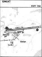
Runways
Runway Summary
| Runways: | 06/24 |
| Longest Runway: | 06/24 is 5583 ft (1702 m) long |
| Runways with an Instrument Approach: |
UMT Airport Runway Details
| Runway 06/24 | 5583 ft x 100 ft (1702 m x 30 m) | |
| Surface: | Gravel/Dirt - Poor condition - No special surface treatment | |
Runway 06 |
Runway 24 |
|
Elevation: |
267.0 | 267.0 |
Latitude: |
69-22-12.5569N | 69-22-19.4543N |
Longitude: |
152-09-23.1931W | 152-06-48.6821W |
|
Runway True Alignment: |
083 | 263 |
Glide Path Angle: |
0.0 degrees | 0.0 degrees |
Traffic Pattern: |
Left | Left |
Object at End: |
BRUSH | BRUSH |
Object Height: |
11 | 6 |
Distance from End: |
0 | 0 |
Object Centerline Offset: |
104 ft. left and right of centerline | 82 ft. left and right of centerline |
Services
Fuel Available: |
100, Jet A |
Landing Fees: |
No |
Maps & Diagrams
UMT Sectional
Flight Planning
at skyvector.com
at skyvector.com