Location
Latitude: |
60-07-47.5891N (60.129886) |
Longitude: |
149-24-59.8660W (-149.416629) |
Elevation: |
27.7 feet MSL (8 m MSL) |
Magnetic Variation: |
14.9 E (as of April 2024 from WMM2020 model) |
Time Zone: |
UTC -9.0 (Standard Time) UTC -8.0 (Daylight Savings Time) |
From City: |
02 N.M. NE of Seward, Alaska |
Found On: |
Seward Chart |
FAA Region: |
AAL |
Contacts
Manager: |
Publicly owned: |
| ROB SMITH 30049 SEWARD HWY MP 23.9 SEWARD, AK 99664 907-262-1187 |
ALASKA DOT&PF CENTRAL REGION PO BOX 196900 ANCHORAGE, AK 99519-6900 907-262-2199 |
Operations
Airport Status: |
Operational |
Facility Use: |
Public |
Type: |
Airport |
Activation Date: |
04/1947 |
Control tower: |
No |
Attendance (Months/Days/Hours): |
Months/Days/Hours Unattended |
Boundary ARTCC: |
ZAN (Anchorage) |
Responsible ARTCC: |
ZAN (Anchorage) |
Lighting Schedule: |
SEE RMK |
Segmented Circle Indicator: |
Yes |
Traffic Pattern Altitude (MSL): |
1028 feet (313 m) |
NOTAMs Facility: |
SWD |
NOTAM-D Service: |
Yes |
International Airport of Entry: |
No |
Customs Landing Rights: |
No |
Military Landing Rights: |
Yes |
Civil/Military Joint Use: |
No |
Based Aircraft
| Single Engine: | 23 |
Annual Operations (as of 12/31/2022)
| Total Operations: | 10510 | |
| Air Taxi: | 4500 | 42.8% |
| GA Local: | 2000 | 19.0% |
| GA Itinerant: | 4000 | 38.1% |
| Military Aircraft: | 10 | 0.1% |
Communications
| CTAF: | 122.900 |
| ASOS: | 135.2 (907-224-2440) |
- APCH/DEP SVC PRVDD BY ANCHORAGE ARTCC ON FREQS. 119.7/269.0 (KENAI RCAG) .
- COMMUNICATIONS PRVDD BY KENAI FSS ON FREQ 122.6 (SEWARD RCO).
Fixed Based Operators (FBOs) & Fuel
(Click on a business for detail)
Please help us keep this information up to date. This is a FREE SERVICE just like everything else on Airport Guide! If you see that a business needs to be added, modified, or deleted please fill out our Update Form.
To add, modify, or delete a business click here.
Please help us keep this information up to date. This is a FREE SERVICE just like everything else on Airport Guide! If you see that a business needs to be added, modified, or deleted please fill out our Update Form.
Area Code: 907 |
| Business Name | Frequency | Phone | Fuel Grade |
|---|
Flight Service Stations
| Primary | Alternate | |
| FSS on Field: | N | |
| FSS Name (ID): | Kenai(ENA) | |
| Frequency: | ||
| Toll Free Phone: | 1-866-864-1737 |
Instrument Procedures / Charts
FAA Terminal Procedures valid from 0901Z 03/21/24 to 0901Z 04/18/24.
There are various types of charts available for an airport. They are listed in the Page Type column. Here is a legend for those types:
APD - Airport Diagram
DP - Departure Procedure Charts
HOT - Hot Spots
IAP - Instrument Approach Procedure Charts
MIN - Minimums
STAR - Standard Terminal Arrival Charts
| Page Type | Page Name | Volume | Action Since Last Cycle |
|---|---|---|---|
| IAP | RNAV (GPS)-A | AK-1 | |
| MIN | ALTERNATE MINIMUMS | AK-1 | |
| MIN | TAKEOFF MINIMUMS | AK-1 | |
| ODP | SEWAR ONE (OBSTACLE) (RNAV) | AK-1 |
Terminal Procedures are only available for airports in several countries with more being added all the time. If you are looking for a specific country's charts, please send an email to support(at)airportguide.com stating the country name. This will be used to prioritize the implementation.
Navigation Aids (Navaids) near SWD
| Dist (NM) | ID | Morse Code | Name | Type | Freq | True Hdg | Mag Hdg |
|---|---|---|---|---|---|---|---|
| 48.1 | OLT | _ _ _ . _ . . _ | Soldotna | NDB-DME | 346 | 296 | 281 |
| 60.2 | IWW | . . . _ _ . _ _ | Wildwood | NDB | 379 | 298 | 283 |
| 60.2 | ENA | . _ . . _ | Kenai | VOR-DME | 117.60 | 299 | 284 |
| 64.3 | TED | _ . _ . . | Anchorage | VOR-DME | 113.15 | 345 | 330 |
| 64.5 | ANC | . _ _ . _ . _ . | Anchorage | VOT | 108.40 | 344 | 329 |
| 65.2 | CMQ | _ . _ . _ _ _ _ . _ | Campbell Lake | NDB | 338 | 343 | 328 |
| 66.3 | HOM | . . . . _ _ _ _ _ | Homer | VOR-DME | 114.60 | 248 | 234 |
| 66.4 | MRI | _ _ . _ . . . | Anchorage | VOT | 111.00 | 349 | 334 |
| 68.3 | EDF | . _ . . . . _ . | Elmendorf | TACAN | 113.40 | 351 | 336 |
| 69.2 | ACE | . _ _ . _ . . | Kachemak | NDB | 277 | 245 | 231 |
| 86.3 | JOH | . _ _ _ _ _ _ . . . . | Johnstone Point | VOR-DME | 116.70 | 74 | 59 |
| 86.7 | ALJ | . _ . _ . . . _ _ _ | Orca Bay | NDB | 233 | 74 | 59 |
| 87.9 | BGQ | _ . . . _ _ . _ _ . _ | Big Lake | VORTAC | 112.50 | 349 | 334 |
Nearby Airports with Fuel
| Dist (NM) | Name (Airport IDs) | True Hdg | Mag Hdg | Fuel Grade |
|---|---|---|---|---|
| 52.5 | Soldotna Airport (SXQ PASX SXQ) |
293 | 279 | 100LL, Jet A |
| 60.4 | Kenai Municipal Airport (ENA PAEN ENA) |
296 | 282 | 100LL, Jet A |
| 64.9 | Ted Stevens Anchorage International Airport (ANC PANC ANC) |
344 | 329 | 100, 100LL, Jet A, Jet A-1 |
| 66.1 | Alaska Regional Hospital Heliport (2OK) |
349 | 334 | 100LL, Jet A |
| 66.2 | Merrill Field Airport (MRI PAMR MRI) |
349 | 334 | 100, Jet A |
| 68.7 | Homer Airport (HOM PAHO HOM) |
245 | 231 | 100LL, Jet A |
| 69.8 | Homer-Beluga Lake Seaplane Base (5BL) |
246 | 232 | 100LL |
| 77.2 | Birchwood Airport (PABV BCV) |
358 | 343 | 100LL |
| 86.6 | Wasilla Airport (WWA PAWS IYS) |
357 | 342 | 100LL, Jet A |
| 87.4 | Wasilla Lake Seaplane Base (5L6) |
0 | 345 | 100LL |
| 88.4 | Warren 'Bud' Woods Palmer Municipal Airport (PAQ PAAQ PAQ) |
6 | 351 | 100LL, Jet A-1 |
Notices to Airmen (NOTAMS)
Remarks
| A110-11 | WX CAMERA AVBL ON INTERNET AT HTTPS://WEATHERCAMS.FAA.GOV |
| A110-13 | BIRDS WI 10 NM SPRING-FALL. |
| A110-14 | FIXED WING OPS OVR 12500 LB NA. |
| A110-15 | COLD TEMPERATURE AIRPORT. ALTITUDE CORRECTION REQUIRED AT OR BELOW -4C. |
| A110-16 | RCMD VISUAL INSP PRIOR TO TKOFF OR LNDG; MNTND ON IREG BASIS. |
| A110-2 | HVY ACFT RSTRD TO N TWY & N 400 FT OF APRON. |
| A110-8 | RCMDD PROC IN EFCT 1 MAY-15 SEP TO AVOID SEASONAL USE HELI 1 NM SSW. |
| A30-16/34 | DURG WINTER 4 IN DIP 15 IN WIDE FM NORTH THR. |
| A30A-31 | APCH SLOPE 0:1. |
| A43-31 | RWY 31 VASI UNUSBL BYD 5 DEG RIGHT OF CNTRLN; OFFSET 5 DEG CLKWS FM CNTRLN. RWY 31 VASI UNUSBL BYD 3 NM; OBSTN CLNC BYD 3 NM NA. |
| A57-13 | CTLG OBSTN EXCEEDS 45 DEG SLOPE. |
| A58-31 | TREES & SHRUBS 100 FT FM RWY END BOTH SIDES. |
| A58-34 | TREES & SHRUBS 0-200 FT FM THR BOTH SIDES. |
| A81-APT | ACTVT VASI RWY 31; MIRL RWY 13/31 - CTAF. |
| E147 | TPA FIXED WING 1000 FT AGL. RWYS 31 & 34 ARRIVALS MAINTAIN AT LEAST 800 FT AGL UNTIL TURNING FINAL. RWYS 13 & 16 DEPARTURES CLIMB STRAIGHT AHEAD TO AT LEAST 800 FT AGL BEFORE TURNING WESTBOUND. |
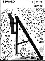
Runways
Runway Summary
| Runways: | 13/31 16/34 |
| Longest Runway: | 13/31 is 4249 ft (1295 m) long |
| Runways with an Instrument Approach: |
SWD Airport Runway Details
| Runway 13/31 | 4249 ft x 100 ft (1295 m x 30 m) | |
| Runway Length Source: | ADO as of 11/18/2019 | |
| Surface: | Asphalt - Good condition - No special surface treatment | |
| Runway Edge Lights: | Medium Intensity | |
Runway 13 |
Runway 31 |
|
Elevation: |
27.7 | 18.7 |
Latitude: |
60-08-03.7500N | 60-07-28.8900N |
Longitude: |
149-25-15.6100W | 149-24-29.1900W |
|
Runway True Alignment: |
146 | 326 |
Glide Path Angle: |
0.0 degrees | 3.0 degrees |
Traffic Pattern: |
Left | Left |
Runway Markings Type: |
Basic | Basic |
Runway Markings Condition: |
Good | Good |
Object at End: |
BRDG | BRUSH |
Object Height: |
6 | 5 |
Distance from End: |
200 | 202 |
Object Centerline Offset: |
90 ft. right of centerline | 35 ft. left of centerline |
Visual Glide Slope Indicators: |
4-Box VASI On Left Side Of Runway | |
Threshold Crossing Height: |
26 |
| Runway 16/34 | 2289 ft x 75 ft (698 m x 23 m) | |
| Runway Length Source: | STATE as of 06/09/2011 | |
| Surface: | Asphalt - Good condition - No special surface treatment | |
Runway 16 |
Runway 34 |
|
Elevation: |
25.4 | 17.4 |
Latitude: |
60-08-01.2000N | 60-07-38.6900N |
Longitude: |
149-25-15.0700W | 149-25-12.3800W |
|
Runway True Alignment: |
177 | 357 |
Glide Path Angle: |
0.0 degrees | 0.0 degrees |
Traffic Pattern: |
Left | Left |
Runway Markings Type: |
Basic | Basic |
Runway Markings Condition: |
Good | Good |
Object at End: |
TREES | |
Object Height: |
68 | |
Distance from End: |
885 | |
Object Centerline Offset: |
90 ft. right of centerline | 35 ft. left of centerline |
Services
Airframe Repair: |
Major |
Powerplant Repair: |
Major |
Bottled Oxygen: |
None |
Bulk Oxygen: |
None |
Fuel Available: |
100LL, Jet A-1 |
Landing Fees: |
No |
Maps & Diagrams
SWD Sectional
Flight Planning
at skyvector.com
at skyvector.com