Location
Latitude: |
37-14-44.3810N (37.245661) |
Longitude: |
093-23-19.0570W (-93.388627) |
Elevation: |
1268.3 feet MSL (387 m MSL) |
Magnetic Variation: |
0.4 E (as of April 2024 from WMM2020 model) |
Time Zone: |
UTC -6.0 (Standard Time) UTC -5.0 (Daylight Savings Time) |
From City: |
05 N.M. NW of Springfield, Missouri |
Found On: |
Kansas City Chart |
FAA Region: |
ACE |
Contacts
Manager: |
Publicly owned: |
| MR. BRIAN C WEILER, A.A.E. 2300 N AIRPORT BLVD, SUITE 100 SPRINGFIELD, MO 65802 417-868-0500 |
CITY OF SPRINGFIELD 2300 N AIRPORT BLVD, SUITE 100 SPRINGFIELD, MO 65802 417-868-0500 |
Operations
Airport Status: |
Operational |
Facility Use: |
Public |
Type: |
Airport |
Control tower: |
Yes |
Attendance (Months/Days/Hours): |
Months/Days/Hours ALL/ALL/ALL |
Boundary ARTCC: |
ZKC (Kansas City) |
Responsible ARTCC: |
ZKC (Kansas City) |
Lighting Schedule: |
SS-SR |
Segmented Circle Indicator: |
No |
Traffic Pattern Altitude (MSL): |
2268 feet (691 m) |
NOTAMs Facility: |
SGF |
NOTAM-D Service: |
Yes |
International Airport of Entry: |
No |
Customs Landing Rights: |
Yes |
Military Landing Rights: |
Yes |
Civil/Military Joint Use: |
No |
Aircraft Rescue and Firefighting: |
Class I ARFF Index: B Air Carrier Service: Scheduled Certification Date: 05/1973 |
Based Aircraft
| Single Engine: | 73 |
| Multi Engine: | 6 |
| Jet Engine: | 33 |
| GA Helicopters: | 3 |
| Military Aircraft: | 10 |
Annual Operations (as of 12/31/2023)
| Total Operations: | 50484 | |
| Commercial: | 14584 | 28.9% |
| Air Taxi: | 9886 | 19.6% |
| GA Local: | 10298 | 20.4% |
| GA Itinerant: | 11901 | 23.6% |
| Military Aircraft: | 3815 | 7.6% |
Communications
| Unicom: | 122.950 |
| Tower: | SPRINGFIELD 119.9 257.8 Hrs: 24 |
| Clearance Del.: | 123.675 |
| Ground: | 121.9 251.15 |
| Approach: | SPRINGFIELD 121.1 ;020-199 124.95 ;200-019 290.5 ;020-199 318.2 ;200-019 Hrs: 24 |
| Departure: | SPRINGFIELD 121.1 ;020-199 124.95 ;200-019 290.5 ;020-199 318.2 ;200-019 Hrs: 24 |
| ATIS: | 135.125 Hrs: 24 |
| ASOS: | (417-863-6158) |
| ARNG OPS: | 245.6 ;BEARS DEN |
| CLASS C: | 121.1 ;020-199 |
| CLASS C: | 290.5 ;020-199 |
| CLASS C: | 124.95 ;200-019 |
| CLASS C: | 318.2 ;200-019 |
| ARNG OPS: | 38.525 ;BEARS DEN |
| ARNG OPS: | 138.75 ;BEARS DEN |
- APCH/DEP HRS CHG ALSO EFFECTS THE FLWG ARPTS; OZARK AIR PARK SOUTH; MONETT MUNI; POINT LOOKOUT M GRAHM CLARK; CASSIVLLE MUNI; AURORA MEML MUNI.
- SPRINGFIELD APCH CTL HAS TWO APCH/DEP CALLS
Fixed Based Operators (FBOs) & Fuel
(Click on a business for detail)
Please help us keep this information up to date. This is a FREE SERVICE just like everything else on Airport Guide! If you see that a business needs to be added, modified, or deleted please fill out our Update Form.
To add, modify, or delete a business click here.
Please help us keep this information up to date. This is a FREE SERVICE just like everything else on Airport Guide! If you see that a business needs to be added, modified, or deleted please fill out our Update Form.
Area Code: 417 |
| Business Name | Frequency | Phone | Fuel Grade |
|---|---|---|---|
| Aviation Enterprises
Update FBO info |
831-2772 | ||
| Pro-Flight Air
Update FBO info |
864-7229 | ||
| Springfield Avionics
Update FBO info |
864-7229 | ||
| Springfield/Branson Regional
Update FBO info |
Unicom 122.95 | 869-0300 | 100LL, Jet A |
| Worldwide Aircraft Services
Update FBO info |
Arinc 130.37 | 865-1879 | 100LL, Jet A |
Flight Service Stations
| Primary | Alternate | |
| FSS on Field: | N | |
| FSS Name (ID): | Columbia(COU) | |
| Frequency: | ||
| Toll Free Phone: | 1-800-WX-BRIEF |
Instrument Procedures / Charts
FAA Terminal Procedures valid from 0901Z 03/21/24 to 0901Z 04/18/24.
There are various types of charts available for an airport. They are listed in the Page Type column. Here is a legend for those types:
APD - Airport Diagram
DP - Departure Procedure Charts
HOT - Hot Spots
IAP - Instrument Approach Procedure Charts
MIN - Minimums
STAR - Standard Terminal Arrival Charts
| Page Type | Page Name | Volume | Action Since Last Cycle |
|---|---|---|---|
| APD | AIRPORT DIAGRAM | NC-3 | Changed |
| HOT | HOT SPOT | NC-3 | |
| IAP | HI-TACAN RWY 20 | NC-3 | |
| IAP | ILS OR LOC RWY 02 | NC-3 | Changed |
| IAP | ILS OR LOC RWY 14 | NC-3 | Changed |
| IAP | RNAV (GPS) RWY 02 | NC-3 | Changed |
| IAP | RNAV (GPS) RWY 14 | NC-3 | Changed |
| IAP | RNAV (GPS) RWY 20 | NC-3 | Changed |
| IAP | RNAV (GPS) RWY 32 | NC-3 | Changed |
| IAP | VOR OR TACAN RWY 20 | NC-3 | Changed |
| IAP | VOR/DME OR TACAN RWY 02 | NC-3 | Changed |
| MIN | ALTERNATE MINIMUMS | NC-3 | |
| MIN | TAKEOFF MINIMUMS | NC-3 |
Terminal Procedures are only available for airports in several countries with more being added all the time. If you are looking for a specific country's charts, please send an email to support(at)airportguide.com stating the country name. This will be used to prioritize the implementation.
Navigation Aids (Navaids) near SGF
| Dist (NM) | ID | Morse Code | Name | Type | Freq | True Hdg | Mag Hdg |
|---|---|---|---|---|---|---|---|
| 7.1 | SGF | . . . _ _ . . . _ . | Springfield | VORTAC | 116.90 | 21 | 21 |
| 27.9 | DGD | _ . . _ _ . _ . . | Dogwood | VORTAC | 109.40 | 118 | 118 |
| 39.9 | IEB | . . . _ . . . | Lebanon | NDB | 414 | 60 | 60 |
| 46.3 | LLU | . _ . . . _ . . . . _ | Spring River | NDB | 356 | 288 | 287 |
| 55.7 | EOS | . _ _ _ . . . | Neosho | DME | 117.3 | 244 | 243 |
| 56.0 | JL | . _ _ _ . _ . . | Lunns | NDB | 344 | 267 | 266 |
| 56.3 | HRO | . . . . . _ . _ _ _ | Harrison | VOR-DME | 112.50 | 171 | 171 |
| 57.3 | RO | . _ . _ _ _ | Rogrs | NDB | 263 | 214 | 213 |
| 60.6 | SHY | . . . . . . . _ . _ _ | Sunshine | VOR-DME | 108.40 | 37 | 37 |
| 64.2 | HR | . . . . . _ . | Bakky | NDB | 395 | 170 | 170 |
| 64.7 | AIZ | . _ . . _ _ . . | Kaiser | NDB | 377 | 37 | 37 |
| 64.9 | PTS | . _ _ . _ . . . | Pittsburg | NDB | 365 | 280 | 279 |
| 66.5 | TBN | _ _ . . . _ . | Forney | VOR | 110.00 | 63 | 63 |
| 66.9 | BHN | _ . . . . . . . _ . | Buckhorn | NDB | 391 | 65 | 65 |
| 68.2 | GLY | _ _ . . _ . . _ . _ _ | Golden Valley | NDB | 388 | 348 | 348 |
| 69.5 | RZC | . _ . _ _ . . _ . _ . | Razorback | VORTAC | 116.40 | 210 | 209 |
| 72.3 | FLP | . . _ . . _ . . . _ _ . | Flippin | DME | 116.05 | 141 | 141 |
| 73.4 | FSK | . . _ . . . . _ . _ | Fort Scott | NDB | 379 | 297 | 296 |
| 74.6 | UNO | . . _ _ . _ _ _ | Pomona | NDB | 335 | 106 | 106 |
| 74.7 | HUW | . . . . . . _ . _ _ | Hutton | DME | 111.6 | 107 | 107 |
Nearby Airports with Fuel
Notices to Airmen (NOTAMS)
Remarks
| A110-1 | BE ALERT FOR POWERED PRCHT ACT INVOF DOWNTOWN ARPT (7 MI ENE OF SGF) AT OR BLO 1,000 FT. |
| A110-11 | ARNG - MO-AVCRAD FAC OPR 1300-2100Z++ MON-FRI EXC HOL. MAINT ASST AVBL DUR NML DUTY HR. FLT ACT OPR 1400-2130Z++ MON-FRI EXC HOL. EXTN HR ON TUES, WED, THU 1400-0200Z++. DUR DST EXTN HR ONLY ON WED, THUR 1400-0500Z++. ARNG-24 HR PPR REQ, VALID 1 HR +/- ETA. FOR PPR, CTC FLT OPS AT C417-874-8460 DUR NML DUTY HR. ALL ACFT RQR CTC BEARS DEN ON 38.525, 138.75 AND 245.6 DEP ACFT RQR TO CTC BEARS DEN TO ADHERE TO ARPT SECURITY MEASURES. TRAN ACFT SHALL ARR AND DEP FR TWY G OR TWY J. A++ FUEL AVBL FOR SUPPORTED AVCRAD ACFT. RWY - ALL RWY GROOVED. RWY 02 RVR-T. TWY 20 RVR-R. RWY 14 RVR-T. RWY 32 RVR-R. |
| A110-2 | BIRDS & WILDLIFE ON & INVOF ARPT. |
| A110-5 | TWY N SOUTH OF RY 14-32 CLSD TO A-321, B727-200, ALL MD 80 SERIES, B-757 AND LARGER ACFT. |
| A110-8 | COMPASS ROSE NORTH OF TWY D AT THE APCH END RWY 32 RESTRICTED TO ACFT WITH FLUX VALVE & STBY COMPASS OF 5.5 FT IN HGT OR HYR. |
| A110-9 | GROUP IV ACFT OR LRGR ON TWY D FROM THE AER 32 TO TWY N AND TWY U ALG CARGO APN MUST PERFORM JUDGMENTAL OVERSTEERING INSTEAD OF COCKPIT OVER CNTRLN WHEN TAX. |
| A14 | DIRECTOR OF AVIATION. |
| A26 | PPR 24 HRS FOR UNSKED ACR OPNS WITH MORE THAN 30 PSGR SEATS CALL SGF 417-868-0590. ARFF INDEX C & D AVBL ON REQUEST. |
| A74 | OXYGEN AVBL MON-FRI 0800-1700. |
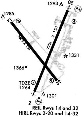
Runways
Runway Summary
| Runways: | 02/20 14/32 |
| Longest Runway: | 14/32 is 8000 ft (2438 m) long |
| Runways with an Instrument Approach: | 02, 14 |
SGF Airport Runway Details
| Runway 02/20 | 7003 ft x 150 ft (2135 m x 46 m) | |
| Runway Length Source: | 3RD PARTY SURVEY as of 06/09/2022 | |
| Surface: | Concrete - Good condition - Saw-cut or plastic grooved | |
| Runway Pavement Class: | 60 /R/C/W/T | |
| Runway Edge Lights: | High Intensity | |
Runway Weight Bearing Capacity (in thousands of pounds) |
||
| Single Wheel Landing Gear: | 135.0 | |
| Dual Wheel Landing Gear: | 170.0 | |
| Dual Tandem Wheel Landing Gear: | 300.0 | |
Runway 02 |
Runway 20 |
|
Elevation: |
1263.9 | 1261.9 |
Latitude: |
37-14-08.3437N | 37-15-12.6265N |
Longitude: |
093-23-21.2248W | 093-22-49.0689W |
|
Runway True Alignment: |
022 | 202 |
ILS Type: |
ILS/DME | |
Glide Path Angle: |
3.0 degrees | 3.0 degrees |
Traffic Pattern: |
Left | Left |
Runway Markings Type: |
Precision Instrument | Precision Instrument |
Runway Markings Condition: |
Good | Good |
Visual Glide Slope Indicators: |
4-Box VASI On Left Side Of Runway | 4-Light PAPI On Left Side Of Runway |
Runway Visual Range (RVR): |
Touchdown | Rollout |
Approach Light System: |
1,400 Foot Medium Intensity Approach Lighting System With Runway Alignment Indicator Lights | 1,400 Foot Medium Intensity Approach Lighting System |
Threshold Crossing Height: |
54 | 47 |
Declared Distances |
||
Take Off Run Avbl. (TORA): |
7003 | 7003 |
Take Off Distance Avbl. (TODA): |
7003 | 7003 |
Actual Stop Dist. Avbl. (ASDA): |
7003 | 7003 |
Landing Dist. Avbl. (LDA): |
7003 | 7003 |
| Runway 14/32 | 8000 ft x 150 ft (2438 m x 46 m) | |
| Runway Length Source: | 3RD PARTY SURVEY as of 06/09/2022 | |
| Surface: | Concrete - Good condition - Saw-cut or plastic grooved | |
| Runway Pavement Class: | 60 /R/C/W/T | |
| Runway Edge Lights: | High Intensity | |
Runway Weight Bearing Capacity (in thousands of pounds) |
||
| Single Wheel Landing Gear: | 135.0 | |
| Dual Wheel Landing Gear: | 170.0 | |
| Dual Tandem Wheel Landing Gear: | 300.0 | |
Runway 14 |
Runway 32 |
|
Elevation: |
1260.2 | 1268.2 |
Latitude: |
37-15-18.8613N | 37-14-16.7177N |
Longitude: |
093-24-01.8361W | 093-23-00.6356W |
|
Runway True Alignment: |
142 | 322 |
ILS Type: |
ILS/DME | |
Glide Path Angle: |
3.0 degrees | 3.0 degrees |
Traffic Pattern: |
Left | Left |
Runway Markings Type: |
Precision Instrument | Nonprecision Instrument |
Runway Markings Condition: |
Good | Good |
Visual Glide Slope Indicators: |
4-Light PAPI On Right Side Of Runway | 4-Light PAPI On Left Side Of Runway |
Runway Visual Range (RVR): |
Touchdown | Rollout |
Approach Light System: |
1,400 Foot Medium Intensity Approach Lighting System With Runway Alignment Indicator Lights | |
REIL: |
No | Yes |
Threshold Crossing Height: |
56 | 35 |
Declared Distances |
||
Take Off Run Avbl. (TORA): |
8000 | 8000 |
Take Off Distance Avbl. (TODA): |
8000 | 8000 |
Actual Stop Dist. Avbl. (ASDA): |
8000 | 8000 |
Landing Dist. Avbl. (LDA): |
8000 | 8000 |
Services
Bottled Oxygen: |
None |
Bulk Oxygen: |
None |
Fuel Available: |
100LL (phillips), MOGAS (conoco) |
Landing Fees: |
No |
Parking: |
Tiedowns available |
Maps & Diagrams
SGF Sectional
Flight Planning
at skyvector.com
at skyvector.com