Location
Latitude: |
35-14-14.1810N (35.237273) |
Longitude: |
120-38-33.3700W (-120.642603) |
Elevation: |
212.3 feet MSL (65 m MSL) |
Magnetic Variation: |
12.2 E (as of April 2024 from WMM2020 model) |
Time Zone: |
UTC -8.0 (Standard Time) UTC -7.0 (Daylight Savings Time) |
From City: |
03 N.M. S of San Luis Obispo, California |
Found On: |
Los Angeles Chart |
FAA Region: |
AWP |
Contacts
Manager: |
Publicly owned: |
| COURTNEY JOHNSON 975 AIRPORT DRIVE, SUITE 1 SAN LUIS OBISPO, CA 93401 805-781-5218 |
SAN LUIS OBISPO COUNTY COUNTY GOVERNMENT CENTER SAN LUIS OBISPO, CA 93408 (805) 781-5205 |
Operations
Airport Status: |
Operational |
Facility Use: |
Public |
Type: |
Airport |
Activation Date: |
04/1940 |
Control tower: |
Yes |
Attendance (Months/Days/Hours): |
Months/Days/Hours ALL/ALL/0600-1700 |
Boundary ARTCC: |
ZLA (Los Angeles) |
Responsible ARTCC: |
ZLA (Los Angeles) |
Lighting Schedule: |
SEE RMK |
Segmented Circle Indicator: |
Yes |
Traffic Pattern Altitude (MSL): |
1212 feet (369 m) |
NOTAMs Facility: |
SBP |
NOTAM-D Service: |
Yes |
International Airport of Entry: |
No |
Customs Landing Rights: |
No |
Military Landing Rights: |
Yes |
Civil/Military Joint Use: |
No |
Aircraft Rescue and Firefighting: |
Class I ARFF Index: B Air Carrier Service: Scheduled Certification Date: 02/1980 |
Based Aircraft
| Single Engine: | 290 |
| Multi Engine: | 16 |
| Jet Engine: | 14 |
| GA Helicopters: | 7 |
Annual Operations (as of 12/31/2022)
| Total Operations: | 83742 | |
| Commercial: | 5697 | 6.8% |
| Air Taxi: | 6020 | 7.2% |
| GA Local: | 30494 | 36.4% |
| GA Itinerant: | 40508 | 48.4% |
| Military Aircraft: | 1023 | 1.2% |
Communications
| CTAF: | 124.000 |
| Unicom: | 122.950 |
| Tower: | SAN LUIS 124.0 379.9 Hrs: 0600-2000 |
| Ground: | 121.6 |
| Approach: | SANTA BARBARA 127.725 127.725 L.A. CENTER ARTCC |
| Departure: | SANTA BARBARA 127.725 127.725 L.A. CENTER ARTCC |
| ATIS: | 120.6 Hrs: 0600-2000 |
| ASOS: | 120.6 (805-547-1260) |
- APCH/DEP CTL SVC PRVDD BY LOS ANGELES ARTCC (ZLA) ON FREQS 119.05/269.5 (SAN LUIS OBISPO RCAG) WHEN SANTA BARBARA APCH CTL (SBA) CLSD.
Fixed Based Operators (FBOs) & Fuel
(Click on a business for detail)
Please help us keep this information up to date. This is a FREE SERVICE just like everything else on Airport Guide! If you see that a business needs to be added, modified, or deleted please fill out our Update Form.
To add, modify, or delete a business click here.
Please help us keep this information up to date. This is a FREE SERVICE just like everything else on Airport Guide! If you see that a business needs to be added, modified, or deleted please fill out our Update Form.
Area Code: 805 |
| Business Name | Frequency | Phone | Fuel Grade |
|---|---|---|---|
| Air San Luis
Update FBO info |
541-1038 | ||
| Cal Coast Flyers
Update FBO info |
Unicom 122.95 | 544-4468 | |
| Cal Coast Fuel
Update FBO info |
Unicom 122.95 | 545-9569 | 100LL, Jet A |
| Coastal Air Maintenance
Update FBO info |
544-4664 | ||
| Executive Aero Club
Website Update FBO info |
805-783-2359 | ||
| Golden State Propeller, Inc.
Update FBO info |
544-8356 | ||
| Helipro, Inc.
Website Update FBO info |
543-2713 | ||
| International Fuel Corporation
Update FBO info |
Unicom 122.95 | 541-3873 | 100LL, Jet A |
| Silva Aviation
Update FBO info |
545-9194 | ||
| Sunwest Aviation
Update FBO info |
547-8622 | ||
| Vintage Aero
Update FBO info |
541-9079 |
Flight Service Stations
| Primary | Alternate | |
| FSS on Field: | N | |
| FSS Name (ID): | Hawthorne(HHR) | |
| Frequency: | ||
| Toll Free Phone: | 1-800-WX-BRIEF |
Instrument Procedures / Charts
FAA Terminal Procedures valid from 0901Z 03/21/24 to 0901Z 04/18/24.
There are various types of charts available for an airport. They are listed in the Page Type column. Here is a legend for those types:
APD - Airport Diagram
DP - Departure Procedure Charts
HOT - Hot Spots
IAP - Instrument Approach Procedure Charts
MIN - Minimums
STAR - Standard Terminal Arrival Charts
| Page Type | Page Name | Volume | Action Since Last Cycle |
|---|---|---|---|
| APD | AIRPORT DIAGRAM | SW-3 | Changed |
| DP | AVILA FOUR | SW-3 | Changed |
| DP | CREPE THREE | SW-3 | Changed |
| DP | WYNNR FOUR | SW-3 | Changed |
| HOT | HOT SPOT | SW-3 | Changed |
| IAP | ILS OR LOC RWY 11 | SW-3 | Changed |
| IAP | LOC RWY 11 | SW-3 | Deleted |
| IAP | RNAV (GPS) RWY 11 | SW-3 | Changed |
| IAP | RNAV (GPS) RWY 29 | SW-3 | Changed |
| IAP | VOR OR TACAN-A | SW-3 | Changed |
| MIN | ALTERNATE MINIMUMS | SW-3 | Changed |
| MIN | TAKEOFF MINIMUMS | SW-3 | Changed |
Terminal Procedures are only available for airports in several countries with more being added all the time. If you are looking for a specific country's charts, please send an email to support(at)airportguide.com stating the country name. This will be used to prioritize the implementation.
Navigation Aids (Navaids) near SBP
| Dist (NM) | ID | Morse Code | Name | Type | Freq | True Hdg | Mag Hdg |
|---|---|---|---|---|---|---|---|
| 5.8 | MQO | _ _ _ _ . _ _ _ _ | Morro Bay | VORTAC | 112.40 | 278 | 266 |
| 18.1 | GLJ | _ _ . . _ . . . _ _ _ | Guadalupe | VOR | 113.05 | 160 | 148 |
| 26.1 | PRB | . _ _ . . _ . _ . . . | Paso Robles | VORTAC | 114.30 | 1 | 349 |
| 30.4 | VBG | . . . _ _ . . . _ _ . | Vandenberg | TACAN | 112.25 | 174 | 162 |
| 39.1 | FLW | . . _ . . _ . . . _ _ | Fellows | VOR-DME | 117.50 | 102 | 90 |
| 40.7 | AVE | . _ . . . _ . | Avenal | VOR-DME | 117.10 | 52 | 40 |
| 50.3 | GVO | _ _ . . . . _ _ _ _ | Gaviota | VORTAC | 113.80 | 147 | 135 |
| 51.0 | HGT | . . . . _ _ . _ | Hunter Liggett | NDB | 209 | 328 | 316 |
| 54.2 | ROM | . _ . _ _ _ _ _ | Priest | VOR | 110.00 | 358 | 346 |
| 61.2 | RZS | . _ . _ _ . . . . . | San Marcus | VORTAC | 114.90 | 135 | 123 |
| 73.6 | COR | _ . _ . _ _ _ . _ . | Salyer Farms | NDB | 205 | 47 | 35 |
| 74.1 | NLC | _ . . _ . . _ . _ . | Lemoore | TACAN | 113.30 | 26 | 14 |
| 74.7 | BSR | _ . . . . . . . _ . | Big Sur | VORTAC | 114.00 | 319 | 307 |
| 77.1 | EHF | . . . . . . . _ . | Shafter | VORTAC | 115.40 | 78 | 66 |
| 78.9 | BFL | _ . . . . . _ . . _ . . | Bakersfield | VOT | 111.20 | 81 | 69 |
| 85.4 | UAD | . . _ . _ _ . . | Chualar | NDB | 263 | 331 | 319 |
| 88.2 | VIS | . . . _ . . . . . | Visalia | VOR-DME | 109.40 | 39 | 27 |
| 88.9 | TTE | _ _ . | Tule | VOR-DME | 116.25 | 62 | 50 |
| 88.9 | PXN | . _ _ . _ . . _ _ . | Panoche | VORTAC | 112.60 | 355 | 343 |
| 91.3 | GMN | _ _ . _ _ _ . | Gorman | VORTAC | 116.10 | 106 | 94 |
Nearby Airports with Fuel
Notices to Airmen (NOTAMS)
Remarks
| A110-1 | RECURRING FLOCKS OF WATERFOWL ON AND IN VICINITY OF ARPT DURG WINTER MONTHS. |
| A110-10 | TWY A BTN TWYS C AND F WILL BE PDCLY RSTRD FOR ACFT WITH WINGSPAN OF 79 FT OR GTR DRG OPNS ON RWY 11/29. |
| A110-2 | TAXILANE WIDTHS LESS THAN STANDARD. |
| A110-3 | NOISE SENSITIVE ARPT; TCH 50 FT; FOR NOISE ABATEMENT INFO CTC AMGR (805) 781-5205. |
| A110-4 | RY 29 DESIGNATED CALM WIND RY. |
| A110-5 | ATCT UNABLE TO SEE ACFT IN HOLDING BAY AT NW END OF TWY A. MOVEMENT FM HOLDING BAY REQUIRES ATCT APVL DURG ATCT HRS. |
| A110-6 | TRANSIENT PARKING EXCEEDING 2 HRS CTC FBO EXCEPT FOR AIR CARRIERS. |
| A110-7 | PUSHBACK FM TRML GATES AT PILOT'S DISCRETION. DO NOT CALL GND CTL FOR PUSHBACK. |
| A110-8 | RWY 7/25 NOT AVBL FOR AIR CARRIER USE. |
| A110-9 | TWY A RUN-UP AREA FOR RWY 29, JETS USE MNM BREAKAWAY PWR. |
| A14 | DEPUTY DIR: CRAIG PIPER (805) 781-4376. |
| A26 | RWY 7/25 NOT AVBL FOR SKED ACR OPNS WITH MORE THAN 9 PSGR SEATS OR UNSKED ACR AT LEAST 31 PSGR SEATS. |
| A30-11/29 | BLAST PAD DEP END RY 11: 600 FT X 200 FT. BLAST PAD DEP END RY 29: 600 FT X 200 FT. |
| A43-11 | UNUSBL BYD 5 DEGS RIGHT OF RWY CNTRLN. |
| A73 | REFIL CUSTOMER BOTTLE. |
| A75 | TSNT TIE DWN PRKING AVBL W SIDE, ADJ SLF SERVE FUEL FACILITY |
| A81-APT | ACTVT MALSR RWY 11; REIL RWY 29; VASI RWY 11; HIRL RWY 11/29 - CTAF. VASI RWY 29 OPR CONSLY. |
| E111 | PRIOR TO 15 MAY 1959. |
| E147 | TPA 991 AGL SINGLE ENG; 1491 AGL MULTI-ENG, JET & HIGH PER. |
| E60-11 | ENGINEERED MATERIAL ARRESTING SYSTEM (EMAS) 300 FT IN LENGTH BY 170 FT IN WIDTH LCTD AT THE DER 11. |
| E60-29 | ENGINEERED MATERIAL ARRESTING SYSTEM (EMAS) 312 FT IN LENGTH BY 170 FT IN WIDTH LCTD AT THE DER 29. |
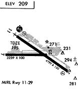
Runways
Runway Summary
| Runways: | 07/25 11/29 |
| Longest Runway: | 11/29 is 6101 ft (1860 m) long |
| Runways with an Instrument Approach: | 11 |
SBP Airport Runway Details
| Runway 07/25 | 2500 ft x 100 ft (762 m x 30 m) | |
| Runway Length Source: | 3RD PARTY SURVEY as of 07/29/2020 | |
| Surface: | Asphalt - Good condition - No special surface treatment | |
| Runway Pavement Class: | 25 /F/D/X/T | |
Runway Weight Bearing Capacity (in thousands of pounds) |
||
| Single Wheel Landing Gear: | 12.5 | |
| Dual Wheel Landing Gear: | 12.5 | |
Runway 07 |
Runway 25 |
|
Elevation: |
162.0 | 189.0 |
Latitude: |
35-14-12.6987N | 35-14-12.7931N |
Longitude: |
120-39-00.9686W | 120-38-30.8374W |
|
Runway True Alignment: |
090 | 270 |
Glide Path Angle: |
0.0 degrees | 0.0 degrees |
Traffic Pattern: |
Left | Left |
Runway Markings Type: |
Basic | Basic |
Runway Markings Condition: |
Good | Good |
Object at End: |
ROAD | |
Object Height: |
10 | |
Distance from End: |
410 | |
REIL: |
No | No |
Touchdown Lights: |
No | No |
Centerline Lights: |
No | No |
Declared Distances |
||
Take Off Run Avbl. (TORA): |
2500 | 2500 |
Take Off Distance Avbl. (TODA): |
2500 | 2500 |
Actual Stop Dist. Avbl. (ASDA): |
2500 | 2500 |
Landing Dist. Avbl. (LDA): |
2500 | 2500 |
| Runway 11/29 | 6101 ft x 150 ft (1860 m x 46 m) | |
| Runway Length Source: | 3RD PARTY SURVEY as of 07/29/2020 | |
| Surface: | Asphalt - Good condition - Saw-cut or plastic grooved | |
| Runway Pavement Class: | 47 /F/D/X/T | |
| Runway Edge Lights: | High Intensity | |
Runway Weight Bearing Capacity (in thousands of pounds) |
||
| Single Wheel Landing Gear: | 112.0 | |
| Dual Wheel Landing Gear: | 147.0 | |
Runway 11 |
Runway 29 |
|
Elevation: |
161.8 | 212.2 |
Latitude: |
35-14-31.9732N | 35-13-57.5628N |
Longitude: |
120-38-58.4412W | 120-37-58.0316W |
|
Runway True Alignment: |
125 | 305 |
ILS Type: |
ILS | |
Glide Path Angle: |
3.0 degrees | 3.2 degrees |
Traffic Pattern: |
Left | Left |
Runway Markings Type: |
Precision Instrument | Nonprecision Instrument |
Runway Markings Condition: |
Good | Good |
Arresting Device: |
EMAS | EMAS |
Visual Glide Slope Indicators: |
4-Box VASI On Left Side Of Runway | 4-Box VASI On Left Side Of Runway |
Approach Light System: |
1,400 Foot Medium Intensity Approach Lighting System With Runway Alignment Indicator Lights | |
REIL: |
No | Yes |
Touchdown Lights: |
No | No |
Centerline Lights: |
No | No |
Threshold Crossing Height: |
50 | 50 |
Threshold Elevation: |
168.1 | 211.7 |
Displaced Threshold: |
800 | 501 |
Threshold Latitude: |
35-14-27.4592N | 35-14-00.3867N |
Threshold Longitude: |
120-38-50.5166W | 120-38-02.9884W |
Declared Distances |
||
Take Off Run Avbl. (TORA): |
6100 | 6100 |
Take Off Distance Avbl. (TODA): |
6100 | 6100 |
Actual Stop Dist. Avbl. (ASDA): |
6100 | 6100 |
Landing Dist. Avbl. (LDA): |
5300 | 5600 |
Services
Airframe Repair: |
Major |
Powerplant Repair: |
Major |
Bottled Oxygen: |
None |
Fuel Available: |
100LL, Jet A |
Landing Fees: |
No |
Parking: |
Tiedowns available |
Maps & Diagrams
SBP Sectional
Flight Planning
at skyvector.com
at skyvector.com