Location
Latitude: |
35-37-01.6000N (35.617111) |
Longitude: |
106-05-21.9000W (-106.089417) |
Elevation: |
6348.7 feet MSL (1935 m MSL) |
Magnetic Variation: |
7.8 E (as of April 2024 from WMM2020 model) |
Time Zone: |
UTC -7.0 (Standard Time) UTC -6.0 (Daylight Savings Time) |
From City: |
09 N.M. SW of Santa Fe, New Mexico |
Found On: |
Albuquerque Chart |
FAA Region: |
ASW |
Contacts
Manager: |
Publicly owned: |
| JAMES HARRIS 121 AVIATION DR SANTA FE, NM 87507-0909 505-955-2900 |
CITY OF SANTA FE PO BOX 909 SANTA FE, NM 87504-0909 505-955-2900 |
Operations
Airport Status: |
Operational |
Facility Use: |
Public |
Type: |
Airport |
Activation Date: |
06/1942 |
Control tower: |
Yes |
Attendance (Months/Days/Hours): |
Months/Days/Hours ALL/ALL/0600-2200 |
Boundary ARTCC: |
ZAB (Albuquerque) |
Responsible ARTCC: |
ZAB (Albuquerque) |
Lighting Schedule: |
SEE RMK |
Segmented Circle Indicator: |
Yes |
Traffic Pattern Altitude (MSL): |
7349 feet (2240 m) |
NOTAMs Facility: |
SAF |
NOTAM-D Service: |
Yes |
International Airport of Entry: |
No |
Customs Landing Rights: |
No |
Military Landing Rights: |
Yes |
Civil/Military Joint Use: |
No |
Aircraft Rescue and Firefighting: |
Class I ARFF Index: A Air Carrier Service: Not Scheduled Certification Date: 11/2005 |
Based Aircraft
| Single Engine: | 130 |
| Multi Engine: | 22 |
| Jet Engine: | 23 |
| GA Helicopters: | 4 |
| Military Aircraft: | 11 |
Annual Operations (as of 07/31/2022)
| Total Operations: | 56053 | |
| Commercial: | 4509 | 8.0% |
| Air Taxi: | 6721 | 12.0% |
| GA Local: | 19707 | 35.2% |
| GA Itinerant: | 22756 | 40.6% |
| Military Aircraft: | 2360 | 4.2% |
Communications
| CTAF: | 119.500 |
| Unicom: | 122.950 |
| Tower: | SANTA FE 119.5 239.3 Hrs: 0700-2100 |
| Ground: | 121.7 |
| Approach: | ALBUQUERQUE ARTCC |
| Departure: | ALBUQUERQUE ARTCC |
| ATIS: | 128.55 Hrs: 24 |
| ASOS: | (505-474-3117) |
| EMERG: | 121.5 |
| EMERG: | 243.0 |
- APCH/DEP SVC PRVDD BY ALBUQUERQUE ARTCC (ZAB) ON FREQS 132.8/346.35 (SANDIA MOUNTAIN RCAG).
Fixed Based Operators (FBOs) & Fuel
(Click on a business for detail)
Please help us keep this information up to date. This is a FREE SERVICE just like everything else on Airport Guide! If you see that a business needs to be added, modified, or deleted please fill out our Update Form.
To add, modify, or delete a business click here.
Please help us keep this information up to date. This is a FREE SERVICE just like everything else on Airport Guide! If you see that a business needs to be added, modified, or deleted please fill out our Update Form.
Area Code: 505 |
| Business Name | Frequency | Phone | Fuel Grade |
|---|---|---|---|
| Air West Aviation
Update FBO info |
471-4500 | ||
| Santa Fe Flight Center
Update FBO info |
473-4643 | ||
| Santa Fe Jet Center
Update FBO info |
Unicom 122.95, Arinc 129.07 | 471-2525, 800-263-7695, after hours call 471-6533 | 100LL, Jet A w/Prist |
| Signature Flight Support
Update FBO info |
Unicom: 122.95, Arinc: 129.07 | +1 505 471 2525 | |
| Zia Aviation
Update FBO info |
Unicom 122.95 | 471-2700 | 100LL, Jet A w/Prist |
Flight Service Stations
| Primary | Alternate | |
| FSS on Field: | N | |
| FSS Name (ID): | Albuquerque(ABQ) | |
| Frequency: | ||
| Toll Free Phone: | 1-800-WX-BRIEF |
Instrument Procedures / Charts
FAA Terminal Procedures valid from 0901Z 03/21/24 to 0901Z 04/18/24.
There are various types of charts available for an airport. They are listed in the Page Type column. Here is a legend for those types:
APD - Airport Diagram
DP - Departure Procedure Charts
HOT - Hot Spots
IAP - Instrument Approach Procedure Charts
MIN - Minimums
STAR - Standard Terminal Arrival Charts
| Page Type | Page Name | Volume | Action Since Last Cycle |
|---|---|---|---|
| APD | AIRPORT DIAGRAM | SW-1 | |
| DP | POAKE TWO | SW-1 | |
| DP | TAFOY THREE | SW-1 | |
| DP | ZIASE FIVE | SW-1 | |
| IAP | ILS OR LOC RWY 02 | SW-1 | |
| IAP | RNAV (GPS) RWY 02 | SW-1 | |
| IAP | RNAV (GPS) RWY 15 | SW-1 | |
| IAP | RNAV (GPS) RWY 20 | SW-1 | |
| IAP | RNAV (GPS) RWY 28 | SW-1 | |
| IAP | RNAV (GPS) RWY 33 | SW-1 | |
| IAP | VOR RWY 33 | SW-1 | |
| IAP | VOR/DME-A | SW-1 | |
| MIN | ALTERNATE MINIMUMS | SW-1 | |
| MIN | TAKEOFF MINIMUMS | SW-1 |
Terminal Procedures are only available for airports in several countries with more being added all the time. If you are looking for a specific country's charts, please send an email to support(at)airportguide.com stating the country name. This will be used to prioritize the implementation.
Navigation Aids (Navaids) near SAF
| Dist (NM) | ID | Morse Code | Name | Type | Freq | True Hdg | Mag Hdg |
|---|---|---|---|---|---|---|---|
| 4.5 | SG | . . . _ _ . | Doman | NDB | 341 | 213 | 205 |
| 4.7 | SAF | . . . . _ . . _ . | Santa Fe | VORTAC | 110.60 | 165 | 157 |
| 33.5 | OTO | _ _ _ _ _ _ _ | Otto | VOR | 114.00 | 167 | 159 |
| 38.8 | AE | . _ . | Dudle | NDB | 351 | 231 | 223 |
| 43.0 | ABQ | . _ _ . . . _ _ . _ | Albuquerque | VOT | 111.00 | 216 | 208 |
| 46.6 | FTI | . . _ . _ . . | Fort Union | VORTAC | 117.30 | 86 | 78 |
| 49.5 | ABQ | . _ _ . . . _ _ . _ | Albuquerque | VORTAC | 113.20 | 226 | 218 |
| 59.6 | ACH | . _ _ . _ . . . . . | Anton Chico | VORTAC | 117.80 | 120 | 113 |
| 60.2 | TAS | _ . _ . . . | Taos | VORTAC | 115.80 | 8 | 0 |
| 68.6 | BRG | _ . . . . _ . _ _ . | Belen | DME | 114.75 | 212 | 204 |
| 77.7 | CNX | _ . _ . _ . _ . . _ | Corona | VORTAC | 115.50 | 164 | 156 |
| 79.0 | CIM | _ . _ . . . _ _ | Cimarron | VORTAC | 116.40 | 48 | 40 |
| 84.7 | ONM | _ _ _ _ . _ _ | Socorro | VORTAC | 116.80 | 205 | 197 |
Nearby Airports with Fuel
| Dist (NM) | Name (Airport IDs) | True Hdg | Mag Hdg | Fuel Grade |
|---|---|---|---|---|
| 18.0 | Los Alamos Airport (LAM KLAM LAM) |
331 | 323 | 100LL |
| 31.6 | Sandia Airpark Estates East Airport (1N1) |
186 | 178 | 100LL |
| 38.6 | Moriarty Municipal Airport (0E0) |
173 | 165 | 100LL, Jet A |
| 43.0 | Albuquerque International Sunport Airport (ABQ KABQ ABQ) |
216 | 208 | 100LL, Jet A, Jet A-1, Jet A-1+ |
| 44.7 | Double Eagle Ii Airport (KAEG AEG) |
230 | 222 | 100LL, Jet A-1 |
| 46.2 | Las Vegas Municipal Airport (LVS KLVS LVS) |
86 | 79 | 100LL, Jet A-1 |
| 54.0 | Taos Regional Airport (TSM KSKX SKX) |
21 | 13 | 100LL, Jet A-1+ |
| 60.6 | Mid Valley Airpark Airport (E98) |
212 | 204 | 100LL |
| 61.9 | Angel Fire Airport (AXX KAXX AXX) |
38 | 31 | 100LL, Jet A+ |
| 68.8 | Belen Regional Airport (BRG) |
212 | 204 | 100LL, Jet A-1+ |
| 81.8 | Santa Rosa Route 66 Airport (KSXU SXU) |
119 | 112 | 100LL, Jet A |
| 92.7 | Grants-Milan Municipal Airport (GNT KGNT GNT) |
253 | 245 | 100LL, Jet A-1+ |
Notices to Airmen (NOTAMS)
Remarks
| A110-3 | RNG ON FLD. |
| A110-6 | NOISE ABATEMENT PROC - AMGR. |
| A110-7 | FOR CD IF UNA TO CTC ON FSS FREQ, CTC ALBUQUERQUE ARTCC AT 505-856-4561. |
| A16 | 505-955-2901, 505-955-2903 |
| A17 | AFT HR SVC - 505-577-7256 OR 505-471-2255. |
| A26 | 24 HR PPR FOR ACR OPS WITH MORE THAN 30 PAX SEATS - 505-955-2900. ARFF INDEX B AVBL ON REQ. |
| A40-02/20 | MIDFIELD LGT COLORED. |
| A81-APT | WHEN ATCT CLSD ACTVT MIRL RWY 02/20, 15/33 - CTAF; MIRL RWY 02/20 PRESET LOW INTST; INCR INTST - CTAF. |
| E147 | R/W TFC PAT ALT 7000 FT MSL. |
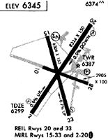
Runways
Runway Summary
| Runways: | 02/20 10/28 15/33 |
| Longest Runway: | 02/20 is 8366 ft (2550 m) long |
| Runways with an Instrument Approach: | 02 |
SAF Airport Runway Details
| Runway 02/20 | 8366 ft x 150 ft (2550 m x 46 m) | |
| Runway Length Source: | 3RD PARTY SURVEY as of 06/24/2011 | |
| Surface: | Asphalt - Poor condition - Porous friction course | |
| Runway Pavement Class: | 46 /F/C/X/T | |
| Runway Edge Lights: | Medium Intensity | |
Runway Weight Bearing Capacity (in thousands of pounds) |
||
| Single Wheel Landing Gear: | 116.0 | |
| Dual Wheel Landing Gear: | 164.0 | |
| Dual Tandem Wheel Landing Gear: | 269.0 | |
Runway 02 |
Runway 20 |
|
Elevation: |
6273.3 | 6348.0 |
Latitude: |
35-36-30.0540N | 35-37-37.7069N |
Longitude: |
106-05-46.2274W | 106-04-47.9540W |
|
Runway True Alignment: |
035 | 215 |
ILS Type: |
ILS/DME | |
Glide Path Angle: |
3.0 degrees | 3.0 degrees |
Traffic Pattern: |
Left | Left |
Runway Markings Type: |
Precision Instrument | Precision Instrument |
Runway Markings Condition: |
Good | Good |
Object at End: |
HILL | |
Object Height: |
6 | |
Distance from End: |
225 | |
Object Centerline Offset: |
226 ft. left of centerline | |
Visual Glide Slope Indicators: |
4-Box VASI On Left Side Of Runway | 4-Box VASI On Left Side Of Runway |
REIL: |
Yes | |
Threshold Crossing Height: |
69 | 54 |
| Runway 10/28 | 6301 ft x 75 ft (1921 m x 23 m) | |
| Runway Length Source: | 3RD PARTY SURVEY as of 06/24/2011 | |
| Surface: | Asphalt - Poor condition - Porous friction course | |
| Runway Pavement Class: | 4 /F/C/Y/T | |
Runway Weight Bearing Capacity (in thousands of pounds) |
||
| Single Wheel Landing Gear: | 12.5 | |
Runway 10 |
Runway 28 |
|
Elevation: |
6281.2 | 6298.2 |
Latitude: |
35-37-14.0191N | 35-36-50.9937N |
Longitude: |
106-06-04.9501W | 106-04-54.0667W |
|
Runway True Alignment: |
112 | 292 |
Glide Path Angle: |
0.0 degrees | 0.0 degrees |
Traffic Pattern: |
Left | Left |
Runway Markings Type: |
Nonprecision Instrument | Nonprecision Instrument |
Runway Markings Condition: |
Good | Good |
Object at End: |
ROAD | |
Object Height: |
11 | |
Distance from End: |
250 | |
Object Centerline Offset: |
226 ft. left of centerline | |
REIL: |
Yes |
| Runway 15/33 | 6316 ft x 100 ft (1925 m x 30 m) | |
| Runway Length Source: | 3RD PARTY SURVEY as of 06/24/2011 | |
| Surface: | Asphalt - Poor condition - Saw-cut or plastic grooved | |
| Runway Pavement Class: | 10 /F/C/Y/T | |
| Runway Edge Lights: | Medium Intensity | |
Runway Weight Bearing Capacity (in thousands of pounds) |
||
| Single Wheel Landing Gear: | 28.0 | |
| Dual Wheel Landing Gear: | 43.5 | |
Runway 15 |
Runway 33 |
|
Elevation: |
6319.1 | 6272.9 |
Latitude: |
35-37-27.9551N | 35-36-27.1831N |
Longitude: |
106-05-29.6160W | 106-05-12.0231W |
|
Runway True Alignment: |
167 | 347 |
Glide Path Angle: |
0.0 degrees | 3.0 degrees |
Traffic Pattern: |
Left | Left |
Runway Markings Type: |
Nonprecision Instrument | Nonprecision Instrument |
Runway Markings Condition: |
Good | Good |
Object Centerline Offset: |
226 ft. left of centerline | |
Visual Glide Slope Indicators: |
4-Box VASI On Right Side Of Runway | |
REIL: |
Yes | Yes |
Threshold Crossing Height: |
86 | |
Declared Distances |
||
Take Off Run Avbl. (TORA): |
6316 | |
Take Off Distance Avbl. (TODA): |
6316 | |
Actual Stop Dist. Avbl. (ASDA): |
5221 | |
Landing Dist. Avbl. (LDA): |
5221 | |
Services
Fuel Available: |
100LL, Jet A-1+ |
Landing Fees: |
No |
Parking: |
Hangars and tiedowns available |
Maps & Diagrams
SAF Sectional
Flight Planning
at skyvector.com
at skyvector.com