Location
Latitude: |
41-26-36.7000N (41.443528) |
Longitude: |
106-49-39.1000W (-106.827528) |
Elevation: |
7014.2 feet MSL (2138 m MSL) |
Magnetic Variation: |
8.8 E (as of April 2024 from WMM2020 model) |
Time Zone: |
UTC -7.0 (Standard Time) UTC -6.0 (Daylight Savings Time) |
From City: |
01 N.M. SW of Saratoga, Wyoming |
Found On: |
Cheyenne Chart |
FAA Region: |
ANM |
Contacts
Manager: |
Publicly owned: |
| BOB MADDOX P.O. BOX 1015 SARATOGA, WY 82331 307-326-8344 |
TOWN OF SARATOGA P.O. BOX 486 SARATOGA, WY 82331 307-326-8335 |
Operations
Airport Status: |
Operational |
Facility Use: |
Public |
Type: |
Airport |
Activation Date: |
05/1946 |
Control tower: |
No |
Attendance (Months/Days/Hours): |
Months/Days/Hours ALL/ALL/0800-1700 |
Boundary ARTCC: |
ZDV (Denver) |
Responsible ARTCC: |
ZDV (Denver) |
Lighting Schedule: |
SEE RMK |
Segmented Circle Indicator: |
Yes |
Traffic Pattern Altitude (MSL): |
8014 feet (2443 m) |
NOTAMs Facility: |
CPR |
NOTAM-D Service: |
Yes |
International Airport of Entry: |
No |
Customs Landing Rights: |
No |
Military Landing Rights: |
Yes |
Civil/Military Joint Use: |
No |
Based Aircraft
| Single Engine: | 16 |
| Jet Engine: | 4 |
Annual Operations (as of 04/30/2022)
| Total Operations: | 7990 | |
| Air Taxi: | 940 | 11.8% |
| GA Local: | 750 | 9.4% |
| GA Itinerant: | 6300 | 78.8% |
Communications
| CTAF: | 122.800 |
| Unicom: | 122.800 |
| AWOS-3PT: | 118.175 (307-326-5387) |
- APCH/DEP CTL SVC PRVDD BY DENVER ARTCC (ZDV) ON FREQS 132.1/254.35 (CHEROKEE RCAG).
Fixed Based Operators (FBOs) & Fuel
(Click on a business for detail)
Please help us keep this information up to date. This is a FREE SERVICE just like everything else on Airport Guide! If you see that a business needs to be added, modified, or deleted please fill out our Update Form.
To add, modify, or delete a business click here.
Please help us keep this information up to date. This is a FREE SERVICE just like everything else on Airport Guide! If you see that a business needs to be added, modified, or deleted please fill out our Update Form.
Area Code: 307 |
| Business Name | Frequency | Phone | Fuel Grade |
|---|---|---|---|
| Saratoga Aviation, Inc.
Update FBO info |
Unicom 122.8 | 326-8344 | 100LL, Jet A |
Flight Service Stations
| Primary | Alternate | |
| FSS on Field: | N | |
| FSS Name (ID): | Casper(CPR) | |
| Frequency: | ||
| Toll Free Phone: | 1-800-WX-BRIEF |
Instrument Procedures / Charts
FAA Terminal Procedures valid from 0901Z 03/21/24 to 0901Z 04/18/24.
There are various types of charts available for an airport. They are listed in the Page Type column. Here is a legend for those types:
APD - Airport Diagram
DP - Departure Procedure Charts
HOT - Hot Spots
IAP - Instrument Approach Procedure Charts
MIN - Minimums
STAR - Standard Terminal Arrival Charts
| Page Type | Page Name | Volume | Action Since Last Cycle |
|---|---|---|---|
| IAP | RNAV (GPS) RWY 05 | NW-1 | |
| IAP | RNAV (GPS) RWY 23 | NW-1 | Changed |
| MIN | ALTERNATE MINIMUMS | NW-1 | |
| MIN | TAKEOFF MINIMUMS | NW-1 | |
| ODP | TRUMA ONE (OBSTACLE) (RNAV) | NW-1 | |
| ODP | TRUMA ONE (OBSTACLE) (RNAV)[DELIMITER] CONT.1 | NW-1 |
Terminal Procedures are only available for airports in several countries with more being added all the time. If you are looking for a specific country's charts, please send an email to support(at)airportguide.com stating the country name. This will be used to prioritize the implementation.
Navigation Aids (Navaids) near SAA
| Dist (NM) | ID | Morse Code | Name | Type | Freq | True Hdg | Mag Hdg |
|---|---|---|---|---|---|---|---|
| 0.2 | SAA | . . . . _ . _ | Saratoga | NDB | 266 | 293 | 284 |
| 27.5 | RWL | . _ . . _ _ . _ . . | Rawlins | VOR-DME | 109.40 | 322 | 313 |
| 38.7 | CKW | _ . _ . _ . _ . _ _ | Cherokee | VOR-DME | 115.00 | 299 | 290 |
| 44.1 | MBW | _ _ _ . . . . _ _ | Medicine Bow | VOR-DME | 116.85 | 56 | 47 |
| 50.2 | LAR | . _ . . . _ . _ . | Laramie | VOR-DME | 117.60 | 96 | 88 |
| 58.8 | BQZ | _ . . . _ _ . _ _ _ . . | Robert | VOR-DME | 112.20 | 181 | 172 |
| 59.5 | CHE | _ . _ . . . . . . | Hayden | VOR-DME | 115.60 | 201 | 192 |
| 88.2 | RLG | . _ . . _ . . _ _ . | Kremmling | VOR-DME | 113.80 | 168 | 159 |
| 88.6 | CP | _ . _ . . _ _ . | Johno | NDB | 375 | 7 | 358 |
| 93.6 | CYS | _ . _ . _ . _ _ . . . | Cheyenne | VORTAC | 113.10 | 97 | 89 |
| 96.5 | EKR | . _ . _ . _ . | Meeker | VOR-DME | 115.20 | 211 | 202 |
| 98.7 | OCS | _ _ _ _ . _ . . . . | Rock Springs | VOR-DME | 116.00 | 275 | 266 |
Nearby Airports with Fuel
| Dist (NM) | Name (Airport IDs) | True Hdg | Mag Hdg | Fuel Grade |
|---|---|---|---|---|
| 27.4 | Rawlins Municipal/Harvey Field Airport (RWL KRWL RWL) |
322 | 313 | 100LL, Jet A |
| 52.5 | Laramie Regional Airport (LAR KLAR LAR) |
98 | 90 | 100LL, Jet A |
| 55.7 | Steamboat Springs/Bob Adams Field Airport (SBS KSBS SBS) |
181 | 172 | 100LL, Jet A |
| 60.4 | Yampa Valley Airport (HDN KHDN HDN) |
197 | 188 | 100LL, Jet A |
| 65.0 | Craig-Moffat Airport (CIG KCAG CAG) |
209 | 200 | 100LL, Jet A |
| 86.0 | Mc Elroy Airfield Airport (20V) |
165 | 157 | 100LL, Jet A |
| 89.2 | Casper/Natrona County International Airport (CPR KCPR CPR) |
10 | 1 | 100LL, Jet A |
| 91.1 | Granby-Grand County Airport (KGNB GNB) |
152 | 144 | 100LL, Jet A |
| 92.5 | Cheyenne Regional/Jerry Olson Field Airport (CYS KCYS CYS) |
100 | 92 | 100LL, Jet A, Jet A-1 |
| 92.6 | Phifer Airfield Airport (EAN KEAN EAN) |
66 | 58 | 100ll, Jet A |
| 96.5 | Meeker Coulter Field Airport (KEEO EEO) |
210 | 201 | 100LL, Jet A |
Notices to Airmen (NOTAMS)
Remarks
| A110-3 | WIND SHEAR OVER HIGHWAY APCH END RWY 23. |
| A110-4 | ANTELOPE MAY BE ON RY. |
| A110-5 | FOR CD CTC DENVER ARTCC AT 303-651-4257. |
| A24 | TURBINE & JET ACFT ONLY. FEES VARY BASED ON CAT OF ACFT. |
| A70-FUEL-A | FULL SVC FUEL. AFT HRS CALL 307-326-8344. |
| A81-APT | ACTVT REIL RWY 5 & 23; PAPI RWY 5 & 23; MIRL RWY 05/23 - CTAF. |
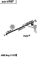
Runways
Runway Summary
| Runways: | 05/23 |
| Longest Runway: | 05/23 is 8801 ft (2683 m) long |
| Runways with an Instrument Approach: |
SAA Airport Runway Details
| Runway 05/23 | 8801 ft x 100 ft (2683 m x 30 m) | |
| Runway Length Source: | 3RD PARTY SURVEY as of 10/10/2008 | |
| Surface: | Asphalt - Good condition - Saw-cut or plastic grooved | |
| Runway Pavement Class: | 50 /F/D/X/U | |
| Runway Edge Lights: | Medium Intensity | |
Runway Weight Bearing Capacity (in thousands of pounds) |
||
| Single Wheel Landing Gear: | 50.0 | |
Runway 05 |
Runway 23 |
|
Elevation: |
7014.2 | 6857.2 |
Latitude: |
41-26-18.9964N | 41-26-54.3692N |
Longitude: |
106-50-31.8304W | 106-48-46.3230W |
|
Runway True Alignment: |
066 | 246 |
Glide Path Angle: |
3.0 degrees | 3.0 degrees |
Traffic Pattern: |
Left | Left |
Runway Markings Type: |
Nonprecision Instrument | Nonprecision Instrument |
Runway Markings Condition: |
Good | Good |
Visual Glide Slope Indicators: |
4-Light PAPI On Left Side Of Runway | 4-Light PAPI On Left Side Of Runway |
REIL: |
Yes | Yes |
Threshold Crossing Height: |
49 | 47 |
Services
Airframe Repair: |
Major |
Powerplant Repair: |
Major |
Bottled Oxygen: |
None |
Bulk Oxygen: |
High Pressure / Low Pressure |
Fuel Available: |
100LL, Jet A |
Landing Fees: |
No |
Parking: |
Hangars and tiedowns available |
Maps & Diagrams
SAA Sectional
Flight Planning
at skyvector.com
at skyvector.com