Location
Latitude: |
35-01-17.9000N (35.021639) |
Longitude: |
094-37-16.5000W (-94.62125) |
Elevation: |
450.9 feet MSL (137 m MSL) |
Magnetic Variation: |
1.3 E (as of April 2024 from WMM2020 model) |
Time Zone: |
UTC -6.0 (Standard Time) UTC -5.0 (Daylight Savings Time) |
From City: |
02 N.M. S of Poteau, Oklahoma |
Found On: |
Memphis Chart |
FAA Region: |
ASW |
Contacts
Manager: |
Publicly owned: |
| ROSSI CHRISTENBERRY 1900 AIRPORT ROAD POTEAU, OK 74953 918-647-4226 |
CITY OF POTEAU CITY HALL, 111 PETERS ST. POTEAU, OK 74953 918-647-4191 |
Operations
Airport Status: |
Operational |
Facility Use: |
Public |
Type: |
Airport |
Activation Date: |
02/1964 |
Control tower: |
No |
Attendance (Months/Days/Hours): |
Months/Days/Hours ALL/ALL/0800-1700 |
Boundary ARTCC: |
ZME (Memphis) |
Responsible ARTCC: |
ZME (Memphis) |
Lighting Schedule: |
SEE RMK |
Segmented Circle Indicator: |
Yes |
Traffic Pattern Altitude (MSL): |
1451 feet (442 m) |
NOTAMs Facility: |
RKR |
NOTAM-D Service: |
Yes |
International Airport of Entry: |
No |
Customs Landing Rights: |
No |
Military Landing Rights: |
Yes |
Civil/Military Joint Use: |
No |
Based Aircraft
| Single Engine: | 15 |
| Multi Engine: | 1 |
| Jet Engine: | 1 |
| GA Helicopters: | 1 |
Annual Operations (as of 05/25/2023)
| Total Operations: | 8024 | |
| Air Taxi: | 24 | 0.3% |
| GA Local: | 5000 | 62.3% |
| GA Itinerant: | 2700 | 33.6% |
| Military Aircraft: | 300 | 3.7% |
Communications
| CTAF: | 122.800 |
| Unicom: | 122.800 |
| Approach: | RAZORBACK 120.9 120.9 MEMPHIS ARTCC |
| Departure: | RAZORBACK 120.9 120.9 MEMPHIS ARTCC |
| AWOS-3: | 120.625 (918-647-4063) |
- APCH/DEP SVC PRVDD BY MEMPHIS ARTCC ON FREQS 126.1/269.0 (FAYETTEVILLE RCAG) WHEN RAZORBACK APCH CTL CLSD.
Fixed Based Operators (FBOs) & Fuel
(Click on a business for detail)
Please help us keep this information up to date. This is a FREE SERVICE just like everything else on Airport Guide! If you see that a business needs to be added, modified, or deleted please fill out our Update Form.
To add, modify, or delete a business click here.
Please help us keep this information up to date. This is a FREE SERVICE just like everything else on Airport Guide! If you see that a business needs to be added, modified, or deleted please fill out our Update Form.
Area Code: 918 |
| Business Name | Frequency | Phone | Fuel Grade |
|---|---|---|---|
| Glenn Aviation
Update FBO info |
Unicom 122.8 | 647-4226 | 100LL |
Flight Service Stations
| Primary | Alternate | |
| FSS on Field: | N | |
| FSS Name (ID): | Mc Alester(MLC) | |
| Frequency: | ||
| Toll Free Phone: | 1-800-WX-BRIEF |
Instrument Procedures / Charts
FAA Terminal Procedures valid from 0901Z 03/21/24 to 0901Z 04/18/24.
There are various types of charts available for an airport. They are listed in the Page Type column. Here is a legend for those types:
APD - Airport Diagram
DP - Departure Procedure Charts
HOT - Hot Spots
IAP - Instrument Approach Procedure Charts
MIN - Minimums
STAR - Standard Terminal Arrival Charts
| Page Type | Page Name | Volume | Action Since Last Cycle |
|---|---|---|---|
| IAP | RNAV (GPS) RWY 18 | SC-1 | |
| IAP | RNAV (GPS) RWY 36 | SC-1 | |
| MIN | ALTERNATE MINIMUMS | SC-1 | |
| MIN | TAKEOFF MINIMUMS | SC-1 |
Terminal Procedures are only available for airports in several countries with more being added all the time. If you are looking for a specific country's charts, please send an email to support(at)airportguide.com stating the country name. This will be used to prioritize the implementation.
Navigation Aids (Navaids) near RKR
| Dist (NM) | ID | Morse Code | Name | Type | Freq | True Hdg | Mag Hdg |
|---|---|---|---|---|---|---|---|
| 19.5 | GK | _ _ . _ . _ | Jembo | NDB | 311 | 21 | 20 |
| 20.5 | PGO | . _ _ . _ _ . _ _ _ | Rich Mountain | VORTAC | 113.50 | 178 | 177 |
| 24.2 | IQS | . . _ _ . _ . . . | Sallisaw | NDB | 520 | 339 | 338 |
| 27.9 | FSM | . . _ . . . . _ _ | Fort Smith | VORTAC | 110.40 | 37 | 36 |
| 28.1 | FS | . . _ . . . . | Wizer | NDB | 223 | 44 | 43 |
| 39.6 | VM | . . . _ _ _ | Fench | NDB | 352 | 136 | 135 |
| 57.5 | TQH | _ _ _ . _ . . . . | Tahlequah | NDB | 215 | 340 | 339 |
| 58.0 | MLC | _ _ . _ . . _ . _ . | Mc Alester | TACAN | 112.00 | 260 | 258 |
| 60.5 | ML | _ _ . _ . . | Wampa | NDB | 344 | 257 | 255 |
| 64.5 | CZE | _ . _ . _ _ . . . | Clarksville | NDB | 201 | 65 | 64 |
| 64.7 | DAK | _ . . . _ _ . _ | Drake | DME | 115.25 | 18 | 17 |
| 70.4 | SLG | . . . . _ . . _ _ . | Siloam Springs | NDB | 284 | 5 | 4 |
| 72.0 | HET | . . . . . _ | Henryetta | NDB | 267 | 288 | 286 |
| 73.0 | OKM | _ _ _ _ . _ _ _ | Okmulgee | VOR-DME | 114.90 | 303 | 301 |
| 74.4 | HHW | . . . . . . . . . _ _ | Hugo | NDB | 323 | 217 | 215 |
| 76.2 | RUE | . _ . . . _ . | Russellville | NDB | 379 | 78 | 77 |
| 77.4 | RZC | . _ . _ _ . . _ . _ . | Razorback | VORTAC | 116.40 | 18 | 17 |
| 78.4 | OK | _ _ _ _ . _ | Preso | NDB | 388 | 304 | 302 |
| 79.2 | HO | . . . . _ _ _ | Hossy | NDB | 385 | 116 | 115 |
| 82.2 | HOT | . . . . _ _ _ _ | Hot Springs | VOR-DME | 110.00 | 112 | 111 |
Nearby Airports with Fuel
Notices to Airmen (NOTAMS)
Remarks
| A110-1 | FOR CD CTC RAZORBACK APCH 479-649-2416, WHEN APCH CLSD CTC MEMPHIS ARTCC AT 901-368-8453/8449. |
| A110-2 | ULTRALIGHT ACT ON & INVOF ARPT. |
| A16 | 918-647-7576. |
| A42-18 | FADED. |
| A42-36 | FADED. |
| A70-FUEL-10 | 0LL AVBL H24 WITH CREDIT CARD. |
| A81-APT | ACTVT ODALS RWY 18; REIL RWY 36 - CTAF. MIRL RWY 18/36 - SS-SR; INCR INTST - CTAF. |
Runways
Runway Summary
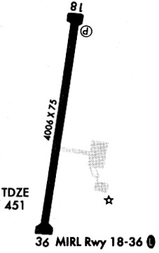
| Runways: | 18/36 |
| Longest Runway: | 18/36 is 4007 ft (1221 m) long |
| Runways with an Instrument Approach: |
RKR Airport Runway Details
| Runway 18/36 | 4007 ft x 75 ft (1221 m x 23 m) | |
| Runway Length Source: | 3RD PARTY SURVEY as of 08/11/2011 | |
| Surface: | Asphalt - Fair condition - No special surface treatment | |
| Runway Edge Lights: | Medium Intensity | |
Runway Weight Bearing Capacity (in thousands of pounds) |
||
| Single Wheel Landing Gear: | 27.0 | |
Runway 18 |
Runway 36 |
|
Elevation: |
447.9 | 450.4 |
Latitude: |
35-01-37.3632N | 35-00-58.3087N |
Longitude: |
094-37-12.4441W | 094-37-20.6067W |
|
Runway True Alignment: |
190 | 010 |
Glide Path Angle: |
3.0 degrees | 3.0 degrees |
Traffic Pattern: |
Left | Left |
Runway Markings Type: |
Nonprecision Instrument | Nonprecision Instrument |
Runway Markings Condition: |
Poor | Poor |
Object at End: |
TREES | |
Object Height: |
54 | |
Distance from End: |
1831 | |
Object Centerline Offset: |
99 ft. left of centerline | |
Visual Glide Slope Indicators: |
4-Light PAPI On Left Side Of Runway | 4-Light PAPI On Left Side Of Runway |
Approach Light System: |
Omnidirectional Approach Lighting System | |
REIL: |
No | Yes |
Threshold Crossing Height: |
42 | 42 |
Services
Fuel Available: |
100LL, Jet A |
Landing Fees: |
No |
Parking: |
Hangars and tiedowns available |
Maps & Diagrams
RKR Sectional
Flight Planning
at skyvector.com
at skyvector.com