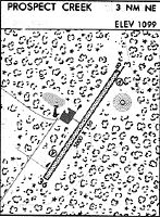
Location
Latitude: |
66-48-50.6000N (66.814056) |
Longitude: |
150-38-37.0000W (-150.643611) |
Elevation: |
1094.7 feet MSL (334 m MSL) |
Magnetic Variation: |
14.6 E (as of April 2024 from WMM2020 model) |
Time Zone: |
UTC -9.0 (Standard Time) UTC -8.0 (Daylight Savings Time) |
From City: |
03 N.M. NE of Prospect Creek, Alaska |
Found On: |
Fairbanks Chart |
FAA Region: |
AAL |
Contacts
Manager: |
Publicly owned: |
| RENIER SWART P.O. BOX 196660, MS 530B, MILTON CROSS ANCHORAGE, AK 99512 907-787-8959 |
ALASKA DOT&PF NORTHERN REGION 2301 PEGER RD FAIRBANKS, AK 99701 907-451-2207 |
Operations
Airport Status: |
Operational |
Facility Use: |
Public |
Type: |
Airport |
Activation Date: |
06/1971 |
Control tower: |
No |
Attendance (Months/Days/Hours): |
Months/Days/Hours Unattended |
Boundary ARTCC: |
ZAN (Anchorage) |
Responsible ARTCC: |
ZAN (Anchorage) |
Lighting Schedule: |
SEE RMK |
Segmented Circle Indicator: |
Yes |
Traffic Pattern Altitude (MSL): |
2095 feet (639 m) |
NOTAMs Facility: |
PPC |
NOTAM-D Service: |
Yes |
International Airport of Entry: |
No |
Customs Landing Rights: |
No |
Military Landing Rights: |
Yes |
Civil/Military Joint Use: |
No |
Based Aircraft
Annual Operations (as of 12/31/2022)
| Total Operations: | 498 | |
| Commercial: | 26 | 5.2% |
| Air Taxi: | 252 | 50.6% |
| GA Local: | 20 | 4.0% |
| GA Itinerant: | 200 | 40.2% |
Communications
| CTAF: | 122.900 |
- APCH/DEP CTL SVC PRVDD BY ANCHORADGE ARTCC (ZAN) ON 124.6/352.0 (BETTLES RCAG).
- PILOTS CAN NOT REACH ATC UNTIL APPROXIMATELY 5000FT-6000FT- GOING INTO AND OUT OF PROSPECT CREEK (PPC).
- FAIRBANKS FSS AVAILABLE ON 122.2
Fixed Based Operators (FBOs) & Fuel
(Click on a business for detail)
Please help us keep this information up to date. This is a FREE SERVICE just like everything else on Airport Guide! If you see that a business needs to be added, modified, or deleted please fill out our Update Form.
To add, modify, or delete a business click here.
Please help us keep this information up to date. This is a FREE SERVICE just like everything else on Airport Guide! If you see that a business needs to be added, modified, or deleted please fill out our Update Form.
Area Code: 907 |
| Business Name | Frequency | Phone | Fuel Grade |
|---|
Flight Service Stations
| Primary | Alternate | |
| FSS on Field: | N | |
| FSS Name (ID): | Fairbanks(FAI) | |
| Frequency: | ||
| Toll Free Phone: | 1-866-248-6516 |
Instrument Procedures / Charts
Terminal Procedures are only available for airports in several countries with more being added all the time. If you are looking for a specific country's charts, please send an email to support(at)airportguide.com stating the country name. This will be used to prioritize the implementation.
Navigation Aids (Navaids) near PPC
| Dist (NM) | ID | Morse Code | Name | Type | Freq | True Hdg | Mag Hdg |
|---|---|---|---|---|---|---|---|
| 0.4 | PPC | . _ _ . . _ _ . _ . _ . | Prospect | NDB | 340 | 41 | 26 |
| 21.7 | BTT | _ . . . _ _ | Bettles | VOR-DME | 116.00 | 284 | 270 |
| 22.2 | EAV | . . _ . . . _ | Evansville | NDB | 391 | 282 | 268 |
| 65.3 | CQR | _ . _ . _ _ . _ . _ . | Chandalar Lake | NDB | 263 | 49 | 34 |
| 83.3 | AKP | . _ _ . _ . _ _ . | Anaktuvuk Pass | NDB | 348 | 342 | 328 |
| 88.2 | UTO | . . _ _ _ _ _ | Utopia Creek | NDB-DME | 272 | 237 | 223 |
Nearby Airports with Fuel
| Dist (NM) | Name (Airport IDs) | True Hdg | Mag Hdg | Fuel Grade |
|---|---|---|---|---|
| 21.7 | Bettles Airport (BTT PABT BTT) |
286 | 272 | 100LL, Jet A-1+ |
| 83.1 | Anaktuvuk Pass Airport (AKP PAKP AKP) |
342 | 328 | Jet A |
Notices to Airmen (NOTAMS)
Remarks
| A110-4 | LTD SNOW REMOVAL. |
| A110-5 | COLD TEMPERATURE AIRPORT. ALTITUDE CORRECTION REQUIRED AT OR BELOW -27C. |
| A110-6 | RWY COND UNMNT; RCMD VISUAL INSP PRIOR TO USE. |
| A81-APT | ACVT REIL RWY 01 & 19; MIRL RWY 01/19 - CTAF. |
| A81-BCN | LCTD ON ALYESKA FLT ADZY BLDG: ON WHEN MANNED. |
Runways
Runway Summary
| Runways: | 01/19 |
| Longest Runway: | 01/19 is 4968 ft (1514 m) long |
| Runways with an Instrument Approach: | 01 |
PPC Airport Runway Details
| Runway 01/19 | 4968 ft x 150 ft (1514 m x 46 m) | |
| Runway Length Source: | 3RD PARTY SURVEY as of 03/11/2005 | |
| Surface: | Gravel - Good condition - No special surface treatment | |
| Runway Edge Lights: | Medium Intensity | |
Runway 01 |
Runway 19 |
|
Elevation: |
1091.1 | 1088.3 |
Latitude: |
66-48-29.8885N | 66-49-11.2013N |
Longitude: |
150-39-10.1366W | 150-38-03.8380W |
|
Runway True Alignment: |
032 | 212 |
ILS Type: |
SDF/DME | |
Glide Path Angle: |
3.0 degrees | 3.0 degrees |
Traffic Pattern: |
Left | Left |
Object at End: |
BRUSH | |
Object Height: |
7 | |
Distance from End: |
22 | |
Object Centerline Offset: |
120 ft. right of centerline | |
Visual Glide Slope Indicators: |
2-Light PAPI On Left Side Of Runway | 2-Light PAPI On Left Side Of Runway |
REIL: |
Yes | Yes |
Threshold Crossing Height: |
39 | 40 |
Services
Fuel Available: |
Jet A |
Landing Fees: |
No |
Maps & Diagrams
PPC Sectional
Flight Planning
at skyvector.com
at skyvector.com