Location
Latitude: |
30-28-24.3000N (30.473417) |
Longitude: |
087-11-11.8000W (-87.186611) |
Elevation: |
120.9 feet MSL (37 m MSL) |
Magnetic Variation: |
3.3 W (as of April 2024 from WMM2020 model) |
Time Zone: |
UTC -6.0 (Standard Time) UTC -5.0 (Daylight Savings Time) |
From City: |
03 N.M. NE of Pensacola, Florida |
Found On: |
New Orleans Chart |
FAA Region: |
ASO |
Contacts
Manager: |
Publicly owned: |
| MATT COUGHLIN, C.M. 2430 AIRPORT BLVD SUITE 225 PENSACOLA, FL 32504 850-436-5000 |
CITY OF PENSACOLA 2430 AIRPORT BLVD SUITE 225 PENSACOLA, FL 32504 850-436-5000 |
Operations
Airport Status: |
Operational |
Facility Use: |
Public |
Type: |
Airport |
Control tower: |
Yes |
Attendance (Months/Days/Hours): |
Months/Days/Hours ALL/ALL/ALL |
Boundary ARTCC: |
ZJX (Jacksonville) |
Responsible ARTCC: |
ZJX (Jacksonville) |
Lighting Schedule: |
SEE RMK |
Segmented Circle Indicator: |
Yes |
Traffic Pattern Altitude (MSL): |
1121 feet (342 m) |
NOTAMs Facility: |
PNS |
NOTAM-D Service: |
Yes |
International Airport of Entry: |
No |
Customs Landing Rights: |
Yes |
Military Landing Rights: |
Yes |
Civil/Military Joint Use: |
No |
Aircraft Rescue and Firefighting: |
Class I ARFF Index: C Air Carrier Service: Scheduled Certification Date: 05/1973 |
Based Aircraft
| Single Engine: | 106 |
| Multi Engine: | 7 |
| Jet Engine: | 15 |
| GA Helicopters: | 3 |
Annual Operations (as of 02/28/2022)
| Total Operations: | 122331 | |
| Commercial: | 26970 | 22.0% |
| Air Taxi: | 14515 | 11.9% |
| GA Local: | 27935 | 22.8% |
| GA Itinerant: | 27631 | 22.6% |
| Military Aircraft: | 25280 | 20.7% |
Communications
| CTAF: | 119.900 |
| Unicom: | 122.950 |
| Tower: | PENSACOLA 119.9 257.8 Hrs: 0530-2300 |
| Clearance Del.: | 123.725 256.875 |
| Ground: | 121.9 348.6 |
| Approach: | PENSACOLA 360.725 |
| Departure: | PENSACOLA 360.725 |
| ATIS: | 121.25 Hrs: 24 |
| ASOS: | 121.25 (850-436-4799) |
| EMERG: | 121.5 |
| EMERG: | 243.0 |
- TA35 LLWAS UNMON 2300-0530.
Fixed Based Operators (FBOs) & Fuel
(Click on a business for detail)
Please help us keep this information up to date. This is a FREE SERVICE just like everything else on Airport Guide! If you see that a business needs to be added, modified, or deleted please fill out our Update Form.
To add, modify, or delete a business click here.
Please help us keep this information up to date. This is a FREE SERVICE just like everything else on Airport Guide! If you see that a business needs to be added, modified, or deleted please fill out our Update Form.
Area Code: 850 |
| Business Name | Frequency | Phone | Fuel Grade |
|---|---|---|---|
| Pensacola Aviation Center
Update FBO info |
Unicom 122.95 | 434-0636 | 100LL, Jet A |
Flight Service Stations
| Primary | Alternate | |
| FSS on Field: | N | |
| FSS Name (ID): | Gainesville(GNV) | |
| Frequency: | ||
| Toll Free Phone: | 1-800-WX-BRIEF |
Instrument Procedures / Charts
FAA Terminal Procedures valid from 0901Z 03/21/24 to 0901Z 04/18/24.
There are various types of charts available for an airport. They are listed in the Page Type column. Here is a legend for those types:
APD - Airport Diagram
DP - Departure Procedure Charts
HOT - Hot Spots
IAP - Instrument Approach Procedure Charts
MIN - Minimums
STAR - Standard Terminal Arrival Charts
| Page Type | Page Name | Volume | Action Since Last Cycle |
|---|---|---|---|
| APD | AIRPORT DIAGRAM | SE-3 | |
| HOT | HOT SPOT | SE-3 | |
| IAP | ILS OR LOC RWY 17 | SE-3 | |
| IAP | LOC RWY 26 | SE-3 | |
| IAP | RNAV (GPS) RWY 08 | SE-3 | |
| IAP | RNAV (GPS) RWY 17 | SE-3 | |
| IAP | RNAV (GPS) RWY 26 | SE-3 | |
| IAP | RNAV (GPS) RWY 35 | SE-3 | |
| IAP | VOR RWY 08 | SE-3 | |
| MIN | ALTERNATE MINIMUMS | SE-3 | |
| MIN | TAKEOFF MINIMUMS | SE-3 |
Terminal Procedures are only available for airports in several countries with more being added all the time. If you are looking for a specific country's charts, please send an email to support(at)airportguide.com stating the country name. This will be used to prioritize the implementation.
Navigation Aids (Navaids) near PNS
| Dist (NM) | ID | Morse Code | Name | Type | Freq | True Hdg | Mag Hdg |
|---|---|---|---|---|---|---|---|
| 2.2 | PKZ | . _ _ . _ . _ _ _ . . | Pickens | NDB | 326 | 168 | 171 |
| 7.7 | NUN | _ . . . _ _ . | Saufley | VOR | 112.25 | 269 | 272 |
| 9.7 | NPA | _ . . _ _ . . _ | Pensacola | TACAN | 117.20 | 224 | 227 |
| 15.4 | NGS | _ . _ _ . . . . | Santa Rosa | TACAN | 133.60 | 56 | 59 |
| 17.4 | NSE | _ . . . . . | Whiting | TACAN | 112.30 | 30 | 33 |
| 25.8 | HRT | . . . . . _ . _ | Hurlburt | TACAN | 110.80 | 95 | 99 |
| 27.9 | ESU | . . . . . . _ | Summerdale | NDB | 204 | 273 | 276 |
| 33.7 | CEW | _ . _ . . . _ _ | Crestview | VORTAC | 115.90 | 50 | 54 |
| 34.4 | DWG | _ . . . _ _ _ _ . | Warrington | TACAN | 134.50 | 89 | 93 |
| 40.5 | CE | _ . _ . . | Kobra | NDB | 201 | 55 | 59 |
| 45.7 | BFM | _ . . . . . _ . _ _ | Brookley | VORTAC | 116.35 | 280 | 283 |
| 59.8 | MVC | _ _ . . . _ _ . _ . | Monroeville | VORTAC | 116.80 | 351 | 354 |
| 60.2 | MOB | _ _ _ _ _ _ . . . | Wisle | NDB | 248 | 286 | 289 |
| 62.4 | SJI | . . . . _ _ _ . . | Semmes | VORTAC | 115.30 | 284 | 287 |
| 64.6 | JUY | . _ _ _ . . _ _ . _ _ | Judd | NDB | 264 | 39 | 43 |
| 73.2 | PFN | . _ _ . . . _ . _ . | Lynne | NDB | 278 | 96 | 100 |
| 76.8 | GCV | _ _ . _ . _ . . . . _ | Greene County | VORTAC | 115.70 | 299 | 302 |
| 80.9 | BVG | _ . . . . . . _ _ _ . | Boll Weevil | NDB | 352 | 49 | 53 |
| 82.5 | EDN | . _ . . _ . | Enterprise | VOR | 116.60 | 52 | 56 |
| 83.8 | OZ | _ _ _ _ _ . . | Brynt | NDB | 212 | 57 | 61 |
Nearby Airports with Fuel
Notices to Airmen (NOTAMS)
Remarks
| A110-1 | BIRDS ON & INVOF ARPT. |
| A110-10 | TWY C SOUTH OF RWY 8/26, C1, C2, TWY D EAST OF RWY 17/35, D1, D2, D3, D4, & D5 ARE 35 FT WIDE; CLSD TO ACFT WITH A WINGSPAN MORE THAN 79 FT. |
| A110-11 | RUN-UP PAD FOR PISTON ACFT LCTD ON TWY D BTWN D1 & C; FACE NOSE OF ACFT S; OTR ACFT RUN-UP INFO - AMGR. |
| A110-13 | CTN: RWY 08 APCHS MAY MISTAKE SAUFLEY FIELD NOLF LCTD 7 MI W FOR PNS. |
| A110-14 | FOR CD IF UNA TO CTC ON FSS FREQ, CTC PENSACOLA APCH AT 850-266-6884 OR 850-266-6885. |
| A110-5 | TBJT WITH MAX TKOF WT OVR 75000 LBS EXCT STD NOISE ABATEMENT DEP PROFILE IAW FAA AC 91-53. |
| A110-6 | FIXED WING VFR DEP PROCD TO ARPT BDRY BFR TURNING UNLESS DRCTD BY ATC. |
| A110-9 | HEL LNDG - PENSACOLA AVIATION 850-434-0636; HEL PRKG LCTD S OF GEN AVN PRKG RAMP BTW TWY C1 & C2 ON CONC PADS. |
| A26 | 24 HR PPR FOR UNSKED ACR OPS MORE THAN 30 PAX SEATS OR UNSKED ACFT MORE THAN 65000 LBS GWT OR WINGSPAN GTR THAN 79 FT - AMGR. |
| A30A-08 | PREFERRED DEP RWY. |
| A30A-26 | BLACK HOLE ILLUSION EXISTS DURG NGT APCH. |
| A52-17 | 4275 FT TWR 900 FT L EL 204. |
| A58-08 | 405 FT TREES R OF CNTRLN 200 FT BFR AER. |
| A81-APT | WHEN ATCT CLSD, ACTVT MALSR RWY 17; TDZ RWY 17; HIRL RWY 17/35, 08/26 - CTAF. |
| E147 | OVHD 1500 FT. |
| E80 | FLT NTFN SVC (ADCUS) AVBL. |
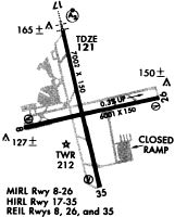
Runways
Runway Summary
| Runways: | 08/26 17/35 |
| Longest Runway: | 17/35 is 7004 ft (2135 m) long |
| Runways with an Instrument Approach: | 26, 17 |
PNS Airport Runway Details
| Runway 08/26 | 7000 ft x 150 ft (2134 m x 46 m) | |
| Runway Length Source: | 3RD PARTY SURVEY as of 10/04/2017 | |
| Surface: | Asphalt - Fair condition - Saw-cut or plastic grooved | |
| Runway Pavement Class: | 65 /F/B/W/T | |
| Runway Edge Lights: | High Intensity | |
Runway Weight Bearing Capacity (in thousands of pounds) |
||
| Single Wheel Landing Gear: | 85.0 | |
| Dual Wheel Landing Gear: | 120.0 | |
| Dual Tandem Wheel Landing Gear: | 250.0 | |
| Dual Dual Tandem Wheel Landing Gear: | 437.0 | |
Runway 08 |
Runway 26 |
|
Elevation: |
97.1 | 113.4 |
Latitude: |
30-28-16.8032N | 30-28-31.1274N |
Longitude: |
087-11-45.3773W | 087-10-27.1197W |
|
Runway True Alignment: |
078 | 258 |
ILS Type: |
LOC/DME | |
Glide Path Angle: |
3.0 degrees | 3.0 degrees |
Traffic Pattern: |
Left | Left |
Runway Markings Type: |
Precision Instrument | Precision Instrument |
Runway Markings Condition: |
Fair | Fair |
Object at End: |
TREES | TREES |
Object Height: |
29 | 43 |
Distance from End: |
1365 | 1690 |
Object Centerline Offset: |
410 ft. right of centerline | 355 ft. left of centerline |
Visual Glide Slope Indicators: |
4-Light PAPI On Left Side Of Runway | 4-Light PAPI On Left Side Of Runway |
REIL: |
Yes | Yes |
Threshold Crossing Height: |
55 | 55 |
| Runway 17/35 | 7004 ft x 150 ft (2135 m x 46 m) | |
| Runway Length Source: | 3RD PARTY SURVEY as of 10/04/2017 | |
| Surface: | Asphalt - Fair condition - Saw-cut or plastic grooved | |
| Runway Pavement Class: | 74 /R/B/W/T | |
| Runway Edge Lights: | High Intensity | |
Runway Weight Bearing Capacity (in thousands of pounds) |
||
| Single Wheel Landing Gear: | 85.0 | |
| Dual Wheel Landing Gear: | 120.0 | |
| Dual Tandem Wheel Landing Gear: | 247.0 | |
| Dual Dual Tandem Wheel Landing Gear: | 461.0 | |
Runway 17 |
Runway 35 |
|
Elevation: |
120.9 | 102.7 |
Latitude: |
30-28-58.4723N | 30-27-50.9313N |
Longitude: |
087-11-26.3617W | 087-11-08.3468W |
|
Runway True Alignment: |
167 | 347 |
ILS Type: |
ILS/DME | |
Glide Path Angle: |
3.0 degrees | 3.0 degrees |
Traffic Pattern: |
Left | Left |
Runway Markings Type: |
Precision Instrument | Precision Instrument |
Runway Markings Condition: |
Good | Good |
Object at End: |
PLINE | |
Object Height: |
86 | |
Distance from End: |
4390 | |
Object Centerline Offset: |
410 ft. right of centerline | 355 ft. left of centerline |
Visual Glide Slope Indicators: |
4-Light PAPI On Left Side Of Runway | 4-Light PAPI On Left Side Of Runway |
Runway Visual Range (RVR): |
Touchdown | Touchdown |
Approach Light System: |
1,400 Foot Medium Intensity Approach Lighting System With Runway Alignment Indicator Lights | |
REIL: |
Yes | |
Touchdown Lights: |
Yes | No |
Centerline Lights: |
Yes | Yes |
Threshold Crossing Height: |
47 | 55 |
Services
Airframe Repair: |
None |
Powerplant Repair: |
None |
Bottled Oxygen: |
None |
Bulk Oxygen: |
None |
Fuel Available: |
100LL |
Landing Fees: |
No |
Parking: |
Tiedowns available |
Maps & Diagrams
PNS Sectional
Flight Planning
at skyvector.com
at skyvector.com