Location
Latitude: |
40-23-56.7200N (40.399089) |
Longitude: |
074-39-32.4230W (-74.659006) |
Elevation: |
128.2 feet MSL (39 m MSL) |
Magnetic Variation: |
12.2 W (as of April 2024 from WMM2020 model) |
Time Zone: |
UTC -5.0 (Standard Time) UTC -4.0 (Daylight Savings Time) |
From City: |
03 N.M. N of Princeton/Rocky Hill, New Jersey |
Found On: |
New York Chart |
FAA Region: |
AEA |
Contacts
Manager: |
Privately owned: |
| KENNETH NIERENBERG PRINCETON ARPT 41 AIRPARK RD PRINCETON, NJ 08540 609-921-3100 |
PRINCETON AERO CORP PRINCETON ARPT 41 AIRPARK RD PRINCETON, NJ 08540 609-921-3100 |
Operations
Airport Status: |
Operational |
Facility Use: |
Public |
Type: |
Airport |
Activation Date: |
04/1938 |
Control tower: |
No |
Attendance (Months/Days/Hours): |
Months/Days/Hours ALL/ALL/0800-DUSK |
Boundary ARTCC: |
ZNY (New York) |
Responsible ARTCC: |
ZNY (New York) |
Lighting Schedule: |
SEE RMK |
Segmented Circle Indicator: |
No |
Traffic Pattern Altitude (MSL): |
1128 feet (344 m) |
NOTAMs Facility: |
MIV |
NOTAM-D Service: |
Yes |
International Airport of Entry: |
No |
Customs Landing Rights: |
No |
Military Landing Rights: |
No |
Civil/Military Joint Use: |
No |
Based Aircraft
| Single Engine: | 27 |
| Multi Engine: | 1 |
| GA Helicopters: | 4 |
Annual Operations (as of 10/23/2020)
| Total Operations: | 39421 | |
| Air Taxi: | 5000 | 12.7% |
| GA Local: | 22718 | 57.6% |
| GA Itinerant: | 11703 | 29.7% |
Communications
| CTAF: | 122.725 |
| Unicom: | 122.725 |
| Approach: | NEW YORK |
| Departure: | NEW YORK |
Fixed Based Operators (FBOs) & Fuel
(Click on a business for detail)
Please help us keep this information up to date. This is a FREE SERVICE just like everything else on Airport Guide! If you see that a business needs to be added, modified, or deleted please fill out our Update Form.
To add, modify, or delete a business click here.
Please help us keep this information up to date. This is a FREE SERVICE just like everything else on Airport Guide! If you see that a business needs to be added, modified, or deleted please fill out our Update Form.
Area Code: 609 |
| Business Name | Frequency | Phone | Fuel Grade |
|---|---|---|---|
| Nassau Helicopters, Inc.
Update FBO info |
Unicom 122.7 | 924-7164 | |
| Princeton Air Corp.
Update FBO info |
Unicom 122.7 | 921-3100 | 100LL, Jet A |
| Princeton Pilot Shoppe
Update FBO info |
921-3100 | ||
| Raritan Valley Flying School
Update FBO info |
Unicom 122.7 | 921-3100 | 100LL, Jet A |
Flight Service Stations
| Primary | Alternate | |
| FSS on Field: | N | |
| FSS Name (ID): | Millville(MIV) | |
| Frequency: | ||
| Toll Free Phone: | 1-800-WX-BRIEF |
Instrument Procedures / Charts
FAA Terminal Procedures valid from 0901Z 03/21/24 to 0901Z 04/18/24.
There are various types of charts available for an airport. They are listed in the Page Type column. Here is a legend for those types:
APD - Airport Diagram
DP - Departure Procedure Charts
HOT - Hot Spots
IAP - Instrument Approach Procedure Charts
MIN - Minimums
STAR - Standard Terminal Arrival Charts
| Page Type | Page Name | Volume | Action Since Last Cycle |
|---|---|---|---|
| DP | PRINCETON ONE | NE-2 | |
| IAP | RNAV (GPS) RWY 10 | NE-2 | |
| IAP | RNAV (GPS) RWY 28 | NE-2 | |
| IAP | VOR-A | NE-2 | |
| MIN | TAKEOFF MINIMUMS | NE-2 | |
| STAR | WILKES-BARRE FOUR | NE-2 |
Terminal Procedures are only available for airports in several countries with more being added all the time. If you are looking for a specific country's charts, please send an email to support(at)airportguide.com stating the country name. This will be used to prioritize the implementation.
Navigation Aids (Navaids) near PCT
| Dist (NM) | ID | Morse Code | Name | Type | Freq | True Hdg | Mag Hdg |
|---|---|---|---|---|---|---|---|
| 11.7 | SBJ | . . . _ . . . . _ _ _ | Solberg | VOR-DME | 112.90 | 341 | 353 |
| 14.0 | RBV | . _ . _ . . . . . . _ | Robbinsville | VORTAC | 113.80 | 147 | 159 |
| 14.3 | ARD | . _ . _ . _ . . | Yardley | VOR-DME | 108.20 | 232 | 244 |
| 23.0 | CAT | _ . _ . . _ _ | Chatham | NDB | 254 | 26 | 38 |
| 23.4 | COL | _ . _ . _ _ _ . _ . . | Colts Neck | VOR-DME | 115.40 | 102 | 114 |
| 23.6 | GXU | _ _ . _ . . _ . . _ | Mc Guire | VORTAC | 110.60 | 172 | 184 |
| 24.9 | PNE | . _ _ . _ . . | North Philadelphia | VOR | 112.00 | 220 | 232 |
| 25.1 | BWZ | _ . . . . _ _ _ _ . . | Broadway | VOR-DME | 114.20 | 342 | 354 |
| 25.9 | NEL | _ . . . _ . . | Lakehurst | TACAN | 111.80 | 147 | 159 |
| 25.9 | NEL | _ . . . _ . . | Lakehurst | NDB | 396 | 145 | 157 |
| 27.5 | EWR | . . _ _ . _ . | Newark | DME | 113.75 | 52 | 64 |
| 28.2 | EWR | . . _ _ . _ . | Maryann | FAN MARKER | 49 | 61 | |
| 29.2 | UKT | . . _ _ . _ _ | Quakertown | NDB | 208 | 273 | 285 |
| 33.0 | ING | . . _ . _ _ . | Ambler | NDB | 275 | 240 | 252 |
| 34.2 | TE | _ . | Torby | NDB | 214 | 44 | 56 |
| 36.4 | CYN | _ . _ . _ . _ _ _ . | Coyle | VORTAC | 113.40 | 163 | 175 |
| 36.8 | OGY | _ _ _ _ _ . _ . _ _ | Bridge | NDB | 414 | 73 | 85 |
| 37.1 | STW | . . . _ . _ _ | Stillwater | VOR-DME | 109.60 | 345 | 357 |
| 37.2 | CRI | _ . _ . . _ . . . | Canarsie | VOR-DME | 112.30 | 69 | 81 |
| 38.3 | TEB | _ . _ . . . | Teterboro | VOR-DME | 108.40 | 45 | 57 |
Nearby Airports with Fuel
Notices to Airmen (NOTAMS)
Remarks
| A110-4 | RWY 28 DEPARTURE NO TURNS UNTIL AT LEAST 900 FT MSL AND BEYOND CHERRY HILL RD. |
| A110-5 | DEER AND BIRDS ON AND INVOF ARPT. |
| A110-6 | FOR CD CTC NEW YORK APCH AT 800-645-3206 |
| A17 | UNATNDD XMAS DAY & NEW YEARS DAY. |
| A23-10 | RY 10/28 RIGHT TFC HELICOPTERS. |
| A33-10/28 | NMRS TRANSVERSE CRACKS ALG ENTR LEN OF RWY. |
| A57-28 | RY 28 APCH SLOPE 21:1 TO DSPLCD THLD. |
| A81-APT | ACTVT MIRL RY 10/28 AND REIL RWY 10 - 123.05. |
| E111 | ESTAB 1927. |
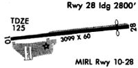
Runways
Runway Summary
| Runways: | 10/28 |
| Longest Runway: | 10/28 is 3499 ft (1066 m) long |
| Runways with an Instrument Approach: |
PCT Airport Runway Details
| Runway 10/28 | 3499 ft x 75 ft (1066 m x 23 m) | |
| Runway Length Source: | 3RD PARTY SURVEY as of 08/25/2019 | |
| Surface: | Asphalt - Fair condition - No special surface treatment | |
| Runway Edge Lights: | Medium Intensity | |
Runway Weight Bearing Capacity (in thousands of pounds) |
||
| Single Wheel Landing Gear: | 15.0 | |
Runway 10 |
Runway 28 |
|
Elevation: |
120.0 | 128.0 |
Latitude: |
40-23-56.5192N | 40-23-56.9202N |
Longitude: |
074-39-55.0357W | 074-39-09.8094W |
|
Runway True Alignment: |
089 | 269 |
Glide Path Angle: |
3.5 degrees | 3.0 degrees |
Traffic Pattern: |
Left | Left |
Runway Markings Type: |
Nonprecision Instrument | Nonprecision Instrument |
Runway Markings Condition: |
Good | Good |
Object at End: |
TREE | BLDG |
Object Height: |
44 | 41 |
Distance from End: |
1503 | 528 |
Object Centerline Offset: |
124 ft. right of centerline | 55 ft. left of centerline |
Visual Glide Slope Indicators: |
2-Light PAPI On Left Side Of Runway | 2-Light PAPI On Left Side Of Runway |
REIL: |
Yes | |
Threshold Crossing Height: |
42 | 41 |
Threshold Elevation: |
128.1 | |
Displaced Threshold: |
369 | |
Threshold Latitude: |
40-23-56.8784N | |
Threshold Longitude: |
074-39-14.5844W |
Services
Airframe Repair: |
Major |
Powerplant Repair: |
Major |
Bulk Oxygen: |
High Pressure / Low Pressure |
Fuel Available: |
100LL, Jet A |
Landing Fees: |
No |
Parking: |
Hangars and tiedowns available |
Maps & Diagrams
PCT Sectional
Flight Planning
at skyvector.com
at skyvector.com