Location
Latitude: |
41-12-23.1950N (41.206443) |
Longitude: |
077-13-32.7550W (-77.225765) |
Elevation: |
554.0 feet MSL (169 m MSL) |
Magnetic Variation: |
11 W (as of April 2024 from WMM2020 model) |
Time Zone: |
UTC -5.0 (Standard Time) UTC -4.0 (Daylight Savings Time) |
From City: |
02 N.M. E of Jersey Shore, Pennsylvania |
Found On: |
Detroit Chart |
FAA Region: |
AEA |
Contacts
Manager: |
Privately owned: |
| JOYCE HENNIGAN 1181 PINE CREEK AVE JERSEY SHORE, PA 17740 570-321-1408 |
THOMAS DUNLAP 1181 PINE CREEK AVE JERSEY SHORE, PA 17740 570-398-1391 |
Operations
Airport Status: |
Operational |
Facility Use: |
Public |
Type: |
Airport |
Activation Date: |
11/1947 |
Control tower: |
No |
Attendance (Months/Days/Hours): |
Months/Days/Hours ALL/ALL/ON CALL |
Boundary ARTCC: |
ZNY (New York) |
Responsible ARTCC: |
ZNY (New York) |
Lighting Schedule: |
SEE RMK |
Segmented Circle Indicator: |
No |
Traffic Pattern Altitude (MSL): |
1554 feet (474 m) |
NOTAMs Facility: |
IPT |
NOTAM-D Service: |
Yes |
International Airport of Entry: |
No |
Customs Landing Rights: |
No |
Military Landing Rights: |
No |
Civil/Military Joint Use: |
No |
Based Aircraft
| Single Engine: | 12 |
| GA Helicopters: | 1 |
Annual Operations (as of 04/25/2023)
| Total Operations: | 1500 | |
| GA Local: | 1000 | 66.7% |
| GA Itinerant: | 500 | 33.3% |
Communications
| CTAF: | 122.700 |
| Unicom: | 122.700 |
- APCH/DEP SVC PRVDD BY NEW YORK ARTCC (ZNY) ON FREQS 134.8/338.3 (PHILIPSBURG RCAG).
Fixed Based Operators (FBOs) & Fuel
(Click on a business for detail)
Please help us keep this information up to date. This is a FREE SERVICE just like everything else on Airport Guide! If you see that a business needs to be added, modified, or deleted please fill out our Update Form.
To add, modify, or delete a business click here.
Please help us keep this information up to date. This is a FREE SERVICE just like everything else on Airport Guide! If you see that a business needs to be added, modified, or deleted please fill out our Update Form.
Area Code: 570 |
| Business Name | Frequency | Phone | Fuel Grade |
|---|
Flight Service Stations
| Primary | Alternate | |
| FSS on Field: | N | |
| FSS Name (ID): | Williamsport(IPT) | |
| Frequency: | ||
| Toll Free Phone: | 1-800-WX-BRIEF |
Instrument Procedures / Charts
Terminal Procedures are only available for airports in several countries with more being added all the time. If you are looking for a specific country's charts, please send an email to support(at)airportguide.com stating the country name. This will be used to prioritize the implementation.
Navigation Aids (Navaids) near P96
| Dist (NM) | ID | Morse Code | Name | Type | Freq | True Hdg | Mag Hdg |
|---|---|---|---|---|---|---|---|
| 21.8 | FQM | . . _ . _ _ . _ _ _ | Williamsport | VOR-DME | 114.40 | 68 | 79 |
| 23.6 | PIX | . _ _ . . . _ . . _ | Picture Rocks | NDB | 344 | 79 | 90 |
| 27.6 | MIP | _ _ . . . _ _ . | Milton | VORTAC | 109.20 | 113 | 124 |
| 29.3 | UN | . . _ _ . | Penue | NDB | 388 | 232 | 243 |
| 29.3 | SEG | . . . . _ _ . | Selinsgrove | VOR-DME | 110.40 | 148 | 159 |
| 30.6 | SFK | . . . . . _ . _ . _ | Stonyfork | VOR-DME | 108.60 | 343 | 354 |
| 38.2 | SLT | . . . . _ . . _ | Slate Run | VORTAC | 113.90 | 298 | 309 |
| 38.8 | PSB | . _ _ . . . . _ . . . | Philipsburg | VORTAC | 115.50 | 243 | 254 |
| 41.4 | ETG | . _ _ _ . | Keating | VORTAC | 116.00 | 271 | 282 |
| 48.4 | RAV | . _ . . _ . . . _ | Ravine | VORTAC | 114.60 | 143 | 154 |
| 51.6 | HZL | . . . . _ _ . . . _ . . | Hazleton | VOR | 109.40 | 105 | 116 |
| 54.0 | ULW | . . _ . _ . . . _ _ | Elmira | VOR-DME | 109.65 | 9 | 20 |
| 54.7 | HAR | . . . . . _ . _ . | Harrisburg | VORTAC | 112.50 | 172 | 183 |
| 55.4 | BZJ | _ . . . _ _ . . . _ _ _ | Bellgrove | NDB | 328 | 146 | 157 |
| 57.5 | TON | _ _ _ _ _ . | Tyrone | VORTAC | 114.90 | 240 | 251 |
| 59.5 | MD | _ _ _ . . | Enola | NDB | 204 | 165 | 176 |
| 62.5 | CX | _ . _ . _ . . _ | Latle | NDB | 219 | 170 | 181 |
| 63.3 | ELZ | . . _ . . _ _ . . | Wellsville | DME | 115.85 | 327 | 338 |
| 64.1 | MDT | _ _ _ . . _ | Harrisburg | VOT | 110.00 | 160 | 171 |
| 65.3 | ALP | . _ . _ . . . _ _ . | Alpine | NDB | 245 | 18 | 29 |
Nearby Airports with Fuel
Notices to Airmen (NOTAMS)
Remarks
| A110-2 | DEER ON & INVOF ARPT. |
| A110-3 | PARL TWY ADJ RWY 09/27 CLSD. |
| A110-4 | FOR CD CTC NEW YORK ARTCC AT 631-468-1425. |
| A16 | 570-279-1025. |
| A57-09 | APCH SLOPE 27:1 TO DSPLCD THLD. |
| A81-APT | ACTVT LIRL RY 09/27 & WIND INDICATOR - CTAF. |
| A81-BCN | RDO-CTL |
Runways
Runway Summary
| Runways: | 09/27 |
| Longest Runway: | 09/27 is 3059 ft (932 m) long |
| Runways with an Instrument Approach: |
P96 Airport Runway Details
| Runway 09/27 | 3059 ft x 130 ft (932 m x 40 m) | |
| Runway Length Source: | FAA-EST as of 06/13/2011 | |
| Surface: | Turf - Excellent condition - No special surface treatment | |
| Runway Edge Lights: | Low Intensity | |
Runway 09 |
Runway 27 |
|
Elevation: |
551.0 | 537.0 |
Latitude: |
41-12-20.9000N | 41-12-25.4900N |
Longitude: |
077-13-52.5000W | 077-13-13.0100W |
Glide Path Angle: |
0.0 degrees | 0.0 degrees |
Traffic Pattern: |
Left | Left |
Object at End: |
ROAD | |
Object Height: |
17 | |
Distance from End: |
149 | |
Object Centerline Offset: |
21 ft. left of centerline | |
Threshold Elevation: |
548.0 | |
Displaced Threshold: |
300 | |
Threshold Latitude: |
41-12-21.3700N | |
Threshold Longitude: |
077-13-48.6100W |
Services
Airframe Repair: |
Minor |
Powerplant Repair: |
Minor |
Bottled Oxygen: |
None |
Bulk Oxygen: |
None |
Fuel Available: |
100LL, Jet A+ |
Landing Fees: |
No |
Parking: |
Tiedowns available |
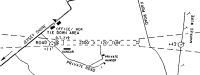
Maps & Diagrams
P96 Sectional
Flight Planning
at skyvector.com
at skyvector.com