Location
Latitude: |
44-57-08.4060N (44.952335) |
Longitude: |
068-40-28.1840W (-68.674496) |
Elevation: |
126.5 feet MSL (39 m MSL) |
Magnetic Variation: |
15.5 W (as of April 2024 from WMM2020 model) |
Time Zone: |
UTC -5.0 (Standard Time) UTC -4.0 (Daylight Savings Time) |
From City: |
02 N.M. NW of Old Town, Maine |
Found On: |
Halifax Chart |
FAA Region: |
ANE |
Contacts
Manager: |
Publicly owned: |
| LANCE FARRAR 100 AIRPORT RD, PO BOX 558 OLD TOWN, ME 04468 207-827-7175 |
CITY OF OLD TOWN 265 MAIN ST OLD TOWN, ME 04468 207-827-3965 |
Operations
Airport Status: |
Operational |
Facility Use: |
Public |
Type: |
Airport |
Activation Date: |
11/1942 |
Control tower: |
No |
Attendance (Months/Days/Hours): |
Months/Days/Hours ALL/ALL/0800-1700 |
Boundary ARTCC: |
ZBW (Boston) |
Responsible ARTCC: |
ZBW (Boston) |
Lighting Schedule: |
SEE RMK |
Segmented Circle Indicator: |
Yes, Lighted |
Traffic Pattern Altitude (MSL): |
1126 feet (343 m) |
NOTAMs Facility: |
BGR |
NOTAM-D Service: |
Yes |
International Airport of Entry: |
No |
Customs Landing Rights: |
No |
Military Landing Rights: |
Yes |
Civil/Military Joint Use: |
No |
Based Aircraft
| Single Engine: | 45 |
| Multi Engine: | 1 |
| GA Helicopters: | 8 |
Annual Operations (as of 08/22/2020)
| Total Operations: | 26700 | |
| GA Local: | 14000 | 52.4% |
| GA Itinerant: | 12000 | 44.9% |
| Military Aircraft: | 700 | 2.6% |
Communications
| CTAF: | 122.800 |
| Unicom: | 122.800 |
| Approach: | BANGOR 118.925 118.925 |
| Departure: | BANGOR 118.925 118.925 |
Fixed Based Operators (FBOs) & Fuel
(Click on a business for detail)
Please help us keep this information up to date. This is a FREE SERVICE just like everything else on Airport Guide! If you see that a business needs to be added, modified, or deleted please fill out our Update Form.
To add, modify, or delete a business click here.
Please help us keep this information up to date. This is a FREE SERVICE just like everything else on Airport Guide! If you see that a business needs to be added, modified, or deleted please fill out our Update Form.
Area Code: 207 |
| Business Name | Frequency | Phone | Fuel Grade |
|---|---|---|---|
| Central Maine Flying Service
Update FBO info |
Unicom 122.8 | 827-5911 | 100LL |
Flight Service Stations
| Primary | Alternate | |
| FSS on Field: | N | |
| FSS Name (ID): | Bangor(BGR) | |
| Frequency: | ||
| Toll Free Phone: | 1-800-WX-BRIEF |
Instrument Procedures / Charts
FAA Terminal Procedures valid from 0901Z 03/21/24 to 0901Z 04/18/24.
There are various types of charts available for an airport. They are listed in the Page Type column. Here is a legend for those types:
APD - Airport Diagram
DP - Departure Procedure Charts
HOT - Hot Spots
IAP - Instrument Approach Procedure Charts
MIN - Minimums
STAR - Standard Terminal Arrival Charts
| Page Type | Page Name | Volume | Action Since Last Cycle |
|---|---|---|---|
| IAP | RNAV (GPS) RWY 12 | NE-1 | |
| IAP | RNAV (GPS) RWY 22 | NE-1 | |
| IAP | RNAV (GPS) RWY 30 | NE-1 | |
| IAP | VOR RWY 22 | NE-1 | |
| MIN | TAKEOFF MINIMUMS | NE-1 |
Terminal Procedures are only available for airports in several countries with more being added all the time. If you are looking for a specific country's charts, please send an email to support(at)airportguide.com stating the country name. This will be used to prioritize the implementation.
Navigation Aids (Navaids) near OLD
| Dist (NM) | ID | Morse Code | Name | Type | Freq | True Hdg | Mag Hdg |
|---|---|---|---|---|---|---|---|
| 3.6 | OLD | _ _ _ . _ . . _ . . | Old Town | NDB | 272 | 28 | 44 |
| 10.8 | BGR | _ . . . _ _ . . _ . | Bangor | VORTAC | 114.80 | 232 | 247 |
| 11.0 | BGR | _ . . . _ _ . . _ . | Bangor | VOT | 111.00 | 213 | 228 |
| 29.4 | BH | _ . . . . . . . | Surry | NDB | 330 | 147 | 163 |
| 32.9 | BUP | _ . . . . . _ . _ _ . | Burnham | NDB | 348 | 242 | 257 |
| 35.5 | BST | _ . . . . . . _ | Belfast | NDB | 278 | 203 | 218 |
| 38.6 | MLT | _ _ . _ . . _ | Millinocket | VOR-DME | 117.90 | 9 | 25 |
| 42.1 | LNT | . _ . . _ . _ | Milnot | NDB | 344 | 7 | 23 |
| 46.9 | PNN | . _ _ . _ . _ . | Princeton | DME | 114.3 | 60 | 76 |
| 54.0 | RL | . _ . . _ . . | Bracy | NDB | 399 | 237 | 252 |
| 56.5 | RM | . _ . _ _ | Noxks | NDB | 334 | 204 | 219 |
| 57.2 | SUH | . . . . . _ . . . . | Sprucehead | NDB | 356 | 198 | 213 |
| 60.1 | AU | . _ . . _ | Dunns | NDB | 366 | 237 | 252 |
| 61.1 | AUG | . _ . . _ _ _ . | Augusta | VOR-DME | 114.95 | 232 | 247 |
| 70.6 | EPM | . . _ _ . _ _ | Eastport | NDB | 260 | 91 | 107 |
| 74.2 | HUL | . . . . . . _ . _ . . | Houlton | DME | 116.1 | 28 | 44 |
| 80.9 | 6E | Grand Manan | NDB | 387 | 99 | 115 | |
| 84.0 | NHZ | _ . . . . . _ _ . . | Brunswick | TACAN | 115.20 | 219 | 234 |
| 88.2 | RQM | . _ . _ _ . _ _ _ | Rangeley | NDB | 221 | 270 | 285 |
| 92.8 | LE | . _ . . . | Lewie | NDB | 240 | 230 | 245 |
Nearby Airports with Fuel
Notices to Airmen (NOTAMS)
Remarks
| A110-1 | WATERFOWL, TURKEY & DEER ON & INVOF ARPT. |
| A110-2 | FBO CLSD SUN. |
| A110-3 | FOR CD CTC BANGOR APCH AT 207-561-2500 EXT 1. |
| A13 | ALTN FONE NR: BILL MAYO, CITY MGR 207-827-3965-EXT 201. |
| A14 | LFARRAR@OLD-TOWN.ORG. |
| A42-04 | FADED. |
| A42-12 | FADED. |
| A42-22 | FADED. |
| A42-30 | FADED. |
| A57-12 | 35:1 TO DTHR. |
| A70-FUEL-A | 24 HR FUEL SELF-SVC WITH MAJOR CREDIT CARD. CREDIT CARD ALSO AVBL AT DOCK. |
| A75 | CALL FOR HNGR AVBL. |
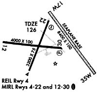
| A81-APT | ACTVT REIL RWY 04; PAPI RWY 22 & 30; MIRL RWY 04/22 - CTAF. |
| E111 | EXISTED PRIOR TO 1959. |
Runways
Runway Summary
| Runways: | 04/22 12/30 17W/35W |
| Longest Runway: | 17W/35W is 8400 ft (2560 m) long |
| Runways with an Instrument Approach: |
OLD Airport Runway Details
| Runway 04/22 | 2802 ft x 75 ft (854 m x 23 m) | |
| Runway Length Source: | 3RD PARTY SURVEY as of 01/09/2019 | |
| Surface: | Asphalt - Good condition - No special surface treatment | |
| Runway Edge Lights: | Medium Intensity | |
Runway Weight Bearing Capacity (in thousands of pounds) |
||
| Single Wheel Landing Gear: | 37.0 | |
| Dual Wheel Landing Gear: | 45.0 | |
Runway 04 |
Runway 22 |
|
Elevation: |
125.9 | 122.2 |
Latitude: |
44-56-51.9957N | 44-57-17.6444N |
Longitude: |
068-40-32.4191W | 068-40-17.8213W |
|
Runway True Alignment: |
022 | 202 |
Glide Path Angle: |
0.0 degrees | 4.0 degrees |
Traffic Pattern: |
Left | Left |
Runway Markings Type: |
Nonprecision Instrument | Nonprecision Instrument |
Runway Markings Condition: |
Poor | Poor |
Object at End: |
TREES | |
Object Height: |
76 | |
Distance from End: |
1650 | |
Object Centerline Offset: |
280 ft. right of centerline | |
Visual Glide Slope Indicators: |
4-Light PAPI On Left Side Of Runway | |
REIL: |
Yes | No |
Touchdown Lights: |
No | No |
Centerline Lights: |
No | No |
Threshold Crossing Height: |
41 |
| Runway 12/30 | 4001 ft x 75 ft (1220 m x 23 m) | |
| Runway Length Source: | 3RD PARTY SURVEY as of 01/09/2019 | |
| Surface: | Asphalt - Good condition - No special surface treatment | |
| Runway Edge Lights: | Medium Intensity | |
Runway Weight Bearing Capacity (in thousands of pounds) |
||
| Single Wheel Landing Gear: | 30.0 | |
Runway 12 |
Runway 30 |
|
Elevation: |
124.7 | 119.1 |
Latitude: |
44-57-13.1622N | 44-57-08.6695N |
Longitude: |
068-40-57.9685W | 068-40-02.6914W |
|
Runway True Alignment: |
097 | 277 |
Glide Path Angle: |
0.0 degrees | 4.0 degrees |
Traffic Pattern: |
Left | Left |
Runway Markings Type: |
Nonprecision Instrument | Nonprecision Instrument |
Runway Markings Condition: |
Poor | Poor |
Object at End: |
TREES | TREES |
Object Height: |
22 | 67 |
Distance from End: |
442 | 1400 |
Object Centerline Offset: |
280 ft. right of centerline | |
Visual Glide Slope Indicators: |
4-Light PAPI On Left Side Of Runway | |
REIL: |
No | No |
Touchdown Lights: |
No | No |
Centerline Lights: |
No | No |
Threshold Crossing Height: |
40 | |
Threshold Elevation: |
122.1 | |
Displaced Threshold: |
689 | |
Threshold Latitude: |
44-57-09.4439N | |
Threshold Longitude: |
068-40-12.2029W |
| Runway 17W/35W | 8400 ft x 100 ft (2560 m x 30 m) | |
| Surface: | Asphalt - Good condition - No special surface treatment | |
Runway 17W |
Runway 35W |
|
Elevation: |
102.0 | 102.0 |
Glide Path Angle: |
0.0 degrees | 0.0 degrees |
Traffic Pattern: |
Left | Left |
Object Centerline Offset: |
280 ft. right of centerline | |
REIL: |
No | No |
Touchdown Lights: |
No | No |
Centerline Lights: |
No | No |
Services
Bottled Oxygen: |
None |
Bulk Oxygen: |
None |
Fuel Available: |
100LL, Jet A |
Landing Fees: |
No |
Parking: |
Hangars and tiedowns available |
Maps & Diagrams
OLD Sectional
Flight Planning
at skyvector.com
at skyvector.com