Location
Latitude: |
40-53-07.8000N (40.8855) |
Longitude: |
077-48-58.4000W (-77.816222) |
Elevation: |
1071.5 feet MSL (327 m MSL) |
Magnetic Variation: |
10.7 W (as of April 2024 from WMM2020 model) |
Time Zone: |
UTC -5.0 (Standard Time) UTC -4.0 (Daylight Savings Time) |
From City: |
03 N.M. SW of Bellefonte, Pennsylvania |
Found On: |
Detroit Chart |
FAA Region: |
AEA |
Contacts
Manager: |
Privately owned: |
| JOHN ELNITSKI 225 SNOWBIRD LA BELLEFONTE, PA 16823 814-355-7407 |
MARINA ELNITSKI 225 SNOWBIRD LA BELLEFONTE, PA 16823 814-355-7407 |
Operations
Airport Status: |
Operational |
Facility Use: |
Public |
Type: |
Airport |
Activation Date: |
08/1971 |
Control tower: |
No |
Attendance (Months/Days/Hours): |
Months/Days/Hours ALL/ALL/0800-DUSK |
Boundary ARTCC: |
ZNY (New York) |
Responsible ARTCC: |
ZNY (New York) |
Lighting Schedule: |
SEE RMK |
Segmented Circle Indicator: |
No |
Traffic Pattern Altitude (MSL): |
2072 feet (632 m) |
NOTAMs Facility: |
AOO |
NOTAM-D Service: |
Yes |
Based Aircraft
| Single Engine: | 19 |
| Multi Engine: | 2 |
| Ultralights: | 2 |
Annual Operations (as of 01/10/2024)
| Total Operations: | 8200 | |
| Air Taxi: | 200 | 2.4% |
| GA Local: | 6000 | 73.2% |
| GA Itinerant: | 2000 | 24.4% |
Communications
| CTAF: | 122.800 |
| Unicom: | 122.800 |
| Clearance Del.: | 125.725 |
| Approach: | NEW YORK ARTCC |
| Departure: | NEW YORK ARTCC |
- APCH/DEP SVC PRVDD BY NEW YORK ARTCC ON FREQS 134.8/338.3 (PHILIPSBURG RCAG).
- CLEARANCE DELIVERY PVDD BY NEW YORK ARTCC ON FREQ 118.55 WHEN UNV TWR CLSD.
Fixed Based Operators (FBOs) & Fuel
(Click on a business for detail)
Please help us keep this information up to date. This is a FREE SERVICE just like everything else on Airport Guide! If you see that a business needs to be added, modified, or deleted please fill out our Update Form.
To add, modify, or delete a business click here.
Please help us keep this information up to date. This is a FREE SERVICE just like everything else on Airport Guide! If you see that a business needs to be added, modified, or deleted please fill out our Update Form.
Area Code: 814 |
| Business Name | Frequency | Phone | Fuel Grade |
|---|---|---|---|
| Pleasant Valley Aviation, Inc.
Update FBO info |
355-7407 |
Flight Service Stations
| Primary | Alternate | |
| FSS on Field: | N | |
| FSS Name (ID): | Altoona(AOO) | |
| Frequency: | ||
| Toll Free Phone: | 1-800-WX-BRIEF |
Instrument Procedures / Charts
FAA Terminal Procedures valid from 0901Z 03/21/24 to 0901Z 04/18/24.
There are various types of charts available for an airport. They are listed in the Page Type column. Here is a legend for those types:
APD - Airport Diagram
DP - Departure Procedure Charts
HOT - Hot Spots
IAP - Instrument Approach Procedure Charts
MIN - Minimums
STAR - Standard Terminal Arrival Charts
| Page Type | Page Name | Volume | Action Since Last Cycle |
|---|---|---|---|
| IAP | RNAV (GPS) RWY 07 | NE-4 | |
| IAP | RNAV (GPS) RWY 25 | NE-4 | |
| MIN | TAKEOFF MINIMUMS | NE-4 |
Terminal Procedures are only available for airports in several countries with more being added all the time. If you are looking for a specific country's charts, please send an email to support(at)airportguide.com stating the country name. This will be used to prioritize the implementation.
Navigation Aids (Navaids) near N96
| Dist (NM) | ID | Morse Code | Name | Type | Freq | True Hdg | Mag Hdg |
|---|---|---|---|---|---|---|---|
| 3.7 | UN | . . _ _ . | Penue | NDB | 388 | 66 | 77 |
| 8.2 | PSB | . _ _ . . . . _ . . . | Philipsburg | VORTAC | 115.50 | 283 | 294 |
| 24.7 | ETG | . _ _ _ . | Keating | VORTAC | 116.00 | 323 | 334 |
| 25.1 | TON | _ _ _ _ _ . | Tyrone | VORTAC | 114.90 | 249 | 260 |
| 38.3 | SLT | . . . . _ . . _ | Slate Run | VORTAC | 113.90 | 349 | 360 |
| 40.3 | AOO | . _ _ _ _ _ _ _ | Altoona | VOR | 108.80 | 213 | 224 |
| 42.7 | SEG | . . . . _ _ . | Selinsgrove | VOR-DME | 110.40 | 97 | 108 |
| 47.0 | REC | . _ . . _ . _ . | Revloc | VOR-DME | 110.60 | 244 | 254 |
| 48.8 | HAR | . . . . . _ . _ . | Harrisburg | VORTAC | 112.50 | 135 | 146 |
| 51.8 | SFK | . . . . . _ . _ . _ | Stonyfork | VOR-DME | 108.60 | 20 | 31 |
| 52.8 | MIP | _ _ . . . _ _ . | Milton | VORTAC | 109.20 | 80 | 91 |
| 54.4 | FQM | . . _ . _ _ . _ _ _ | Williamsport | VOR-DME | 114.40 | 59 | 70 |
| 55.3 | PIX | . _ _ . . . _ . . _ | Picture Rocks | NDB | 344 | 64 | 75 |
| 56.3 | CX | _ . _ . _ . . _ | Latle | NDB | 219 | 138 | 149 |
| 56.7 | MD | _ _ _ . . | Enola | NDB | 204 | 132 | 143 |
| 57.5 | THS | _ . . . . . . . | St Thomas | VORTAC | 115.00 | 186 | 197 |
| 57.6 | JST | . _ _ _ . . . _ | Johnstown | VOR-DME | 113.00 | 233 | 243 |
| 58.8 | INP | . . _ . . _ _ . | Indiana | NDB | 242 | 255 | 265 |
| 58.8 | RAV | . _ . . _ . . . _ | Ravine | VORTAC | 114.60 | 109 | 120 |
| 63.3 | MDT | _ _ _ . . _ | Harrisburg | VOT | 110.00 | 130 | 141 |
Nearby Airports with Fuel
Notices to Airmen (NOTAMS)
Remarks
| A110-1 | ULTRA-LIGHTS ON & INVOF ARPT. |
| A110-4 | ALL HELI RQRD TO USE FIXED WING TFC PAT. |
| A110-5 | HVY GLIDER ACT DURG DALGT HRS, ALL ALTS WI 10 NM AREA, ALL DRCTNS, SPCLY ALG RIDGE 1 NM WEST & NORTH OF ARPT. |
| A110-6 | CTC UNV TWR(UNIVERSITY PARK) 128.475 PRIOR TO ENTERING CLASS D ASP. |
| A17 | FOR SVC AFT HRS CTC 814-355-7407 OR 814-883-7646. |
| A40-07/25 | RWY 25 THR LGTS LCTD 43 FT PAST RWY THR MKG. |
| A42-07 | RWY MARKINGS EXTREMELY FADED. |
| A42-25 | RWY MARKINGS EXTREMELY FADED. |
| A81-APT | ACTVT PAPI RWY 25; LIRL RWY 07/25 - 122.7. |
| A81-BCN | ACTVT ARPT BCN - 122.7. |
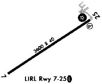
Runways
Runway Summary
| Runways: | 07/25 |
| Longest Runway: | 07/25 is 3632 ft (1107 m) long |
| Runways with an Instrument Approach: |
N96 Airport Runway Details
| Runway 07/25 | 3632 ft x 60 ft (1107 m x 18 m) | |
| Runway Length Source: | 3RD PARTY SURVEY as of 06/26/2012 | |
| Surface: | Asphalt - Fair condition - No special surface treatment | |
| Runway Edge Lights: | Non-standard lighting system Intensity | |
Runway 07 |
Runway 25 |
|
Elevation: |
1068.9 | 1057.4 |
Latitude: |
40-52-57.8959N | 40-53-17.7556N |
Longitude: |
077-49-18.1218W | 077-48-38.7415W |
|
Runway True Alignment: |
056 | 236 |
Glide Path Angle: |
0.0 degrees | 3.5 degrees |
Traffic Pattern: |
Left | Right |
Runway Markings Type: |
Nonprecision Instrument | Nonprecision Instrument |
Runway Markings Condition: |
Poor | Poor |
Object at End: |
TREE | |
Object Height: |
29 | |
Distance from End: |
270 | |
Object Centerline Offset: |
168 ft. right of centerline | |
Visual Glide Slope Indicators: |
2-Light PAPI On Left Side Of Runway | |
Threshold Crossing Height: |
40 |
Services
Airframe Repair: |
Major |
Powerplant Repair: |
Major |
Bottled Oxygen: |
None |
Bulk Oxygen: |
None |
Fuel Available: |
100LL |
Landing Fees: |
No |
Parking: |
Tiedowns available |
Maps & Diagrams
N96 Sectional
Flight Planning
at skyvector.com
at skyvector.com