Location
Latitude: |
41-23-36.3030N (41.393418) |
Longitude: |
070-36-49.9480W (-70.613874) |
Elevation: |
66.9 feet MSL (20 m MSL) |
Magnetic Variation: |
14.1 W (as of April 2024 from WMM2020 model) |
Time Zone: |
UTC -5.0 (Standard Time) UTC -4.0 (Daylight Savings Time) |
From City: |
03 N.M. S of Vineyard Haven, Massachusetts |
Found On: |
New York Chart |
FAA Region: |
ANE |
Contacts
Manager: |
Publicly owned: |
| GEOFFREY R. FREEMAN 71 AIRPORT ROAD, 71 AIRPORT ROAD VINEYARD HAVEN, MA 02568 508-693-7022 |
COUNTY OF DUKES COUNTY 71 AIRPORT ROAD, 71 AIRPORT RAOD VINEYARD HAVEN, MA 02568 5086937022 |
Operations
Airport Status: |
Operational |
Facility Use: |
Public |
Type: |
Airport |
Activation Date: |
07/1974 |
Control tower: |
Yes |
Attendance (Months/Days/Hours): |
Months/Days/Hours ALL/ALL/ALL |
Boundary ARTCC: |
ZBW (Boston) |
Responsible ARTCC: |
ZBW (Boston) |
Lighting Schedule: |
SEE RMK |
Segmented Circle Indicator: |
Yes |
Traffic Pattern Altitude (MSL): |
1067 feet (325 m) |
NOTAMs Facility: |
MVY |
NOTAM-D Service: |
Yes |
International Airport of Entry: |
No |
Customs Landing Rights: |
No |
Military Landing Rights: |
Yes |
Civil/Military Joint Use: |
No |
Aircraft Rescue and Firefighting: |
Class I ARFF Index: B Air Carrier Service: Scheduled Certification Date: 05/1973 |
Based Aircraft
| Single Engine: | 70 |
| Multi Engine: | 14 |
| Jet Engine: | 1 |
| GA Helicopters: | 2 |
Annual Operations (as of 04/30/2022)
| Total Operations: | 44640 | |
| Commercial: | 2023 | 4.5% |
| Air Taxi: | 19442 | 43.6% |
| GA Local: | 2810 | 6.3% |
| GA Itinerant: | 19701 | 44.1% |
| Military Aircraft: | 664 | 1.5% |
Communications
| CTAF: | 121.400 |
| Unicom: | 122.950 |
| Tower: | VINEYARD 121.4 Hrs: 0600-2200 MAY 15 - OCT 31; 0700-1700 NOV 1 MAY14 |
| Clearance Del.: | 124.35 119.7 ;WHEN TWR CLSD 119.7 ;WHEN TWR CLSD |
| Ground: | 124.35 |
| Approach: | BOSTON BOSTON ARTCC |
| Departure: | BOSTON BOSTON ARTCC |
| ATIS: | 126.25 Hrs: 24 |
| ASOS: | 126.25 (508-696-6988) |
| EMERG: | 121.5 |
- APCH/DEP SVC PRVDD BY BOSTON ARTCC ON FREQS 128.75/290.3 (BARNSTABLE RCAG) 0000-0500.
- TWR OPRD UNDER CONTR TO MIDWEST ATC.
Fixed Based Operators (FBOs) & Fuel
(Click on a business for detail)
Please help us keep this information up to date. This is a FREE SERVICE just like everything else on Airport Guide! If you see that a business needs to be added, modified, or deleted please fill out our Update Form.
To add, modify, or delete a business click here.
Please help us keep this information up to date. This is a FREE SERVICE just like everything else on Airport Guide! If you see that a business needs to be added, modified, or deleted please fill out our Update Form.
Area Code: 508 |
| Business Name | Frequency | Phone | Fuel Grade |
|---|---|---|---|
| Flywright Aviation, Inc.
Website Update FBO info |
Unicom 123.3 | 693-1067 | |
| Martha's Vineyard Airport
Website Update FBO info |
Unicom 122.95 | 693-7022, 693-1067 | 100LL, Jet A |

|
 Texaco |
100LL - 2.60 USD per gallon on 8/25/01 |
Pumps or trucks Fuel available 6a - 10p Information provided by phone |
|
|
Texaco |
Jet A - 2.50 USD per gallon on 8/25/01 |
Pumps or trucks - Discount for 200 gallons or more - Prist is 5 cents extra per gallon - Fuel available 6a - 10p Information provided by phone |
Flight Service Stations
| Primary | Alternate | |
| FSS on Field: | N | |
| FSS Name (ID): | Bridgeport(BDR) | |
| Frequency: | ||
| Toll Free Phone: | 1-800-WX-BRIEF |
Instrument Procedures / Charts
FAA Terminal Procedures valid from 0901Z 03/21/24 to 0901Z 04/18/24.
There are various types of charts available for an airport. They are listed in the Page Type column. Here is a legend for those types:
APD - Airport Diagram
DP - Departure Procedure Charts
HOT - Hot Spots
IAP - Instrument Approach Procedure Charts
MIN - Minimums
STAR - Standard Terminal Arrival Charts
| Page Type | Page Name | Volume | Action Since Last Cycle |
|---|---|---|---|
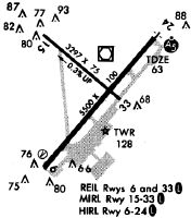
| APD | AIRPORT DIAGRAM | NE-1 | |
| IAP | ILS OR LOC RWY 24 | NE-1 | |
| IAP | RNAV (GPS) RWY 06 | NE-1 | |
| IAP | RNAV (GPS) RWY 15 | NE-1 | |
| IAP | RNAV (GPS) RWY 24 | NE-1 | |
| IAP | RNAV (GPS) RWY 33 | NE-1 | |
| IAP | VOR RWY 06 | NE-1 | |
| MIN | ALTERNATE MINIMUMS | NE-1 | |
| MIN | TAKEOFF MINIMUMS | NE-1 |
Terminal Procedures are only available for airports in several countries with more being added all the time. If you are looking for a specific country's charts, please send an email to support(at)airportguide.com stating the country name. This will be used to prioritize the implementation.
Navigation Aids (Navaids) near MVY
| Dist (NM) | ID | Morse Code | Name | Type | Freq | True Hdg | Mag Hdg |
|---|---|---|---|---|---|---|---|
| 0.2 | MVY | _ _ . . . _ _ . _ _ | Marthas Vineyard | VOR-DME | 114.50 | 17 | 31 |
| 16.6 | FMH | . . _ . _ _ . . . . | Otis | TACAN | 115.80 | 15 | 29 |
| 21.8 | FM | . . _ . _ _ | Bomde | NDB | 362 | 20 | 34 |
| 27.3 | ACK | . _ _ . _ . _ . _ | Nantucket | VOR-DME | 116.20 | 104 | 118 |
| 33.3 | CQX | _ . _ . _ _ . _ _ . . _ | Nauset | NDB | 279 | 57 | 71 |
| 34.1 | TAN | _ . _ _ . | Taunton | NDB | 227 | 328 | 342 |
| 41.5 | PVD | . _ _ . . . . _ _ . . | Providence | VOT | 108.20 | 298 | 312 |
| 41.6 | AR | . _ . _ . | Armin | NDB | 356 | 307 | 321 |
| 41.7 | PVD | . _ _ . . . . _ _ . . | Providence | VOR-DME | 115.60 | 298 | 312 |
| 42.4 | IMR | . . _ _ . _ . | Marshfield | NDB | 368 | 356 | 370 |
| 44.1 | PVC | . _ _ . . . . _ _ . _ . | Provincetown | NDB | 389 | 23 | 37 |
| 44.9 | IHM | . . . . . . _ _ | Mansfield | NDB | 220 | 324 | 338 |
| 45.5 | SEY | . . . . _ . _ _ | Sandy Point | VOR-DME | 117.80 | 252 | 266 |
| 45.5 | LFV | . _ . . . . _ . . . . _ | Marconi | VOR-DME | 114.70 | 34 | 48 |
| 49.3 | OW | _ _ _ . _ _ | Stoge | NDB | 397 | 332 | 346 |
| 60.2 | BOS | _ . . . _ _ _ . . . | Boston | VOT | 111.00 | 343 | 357 |
| 60.2 | BOS | _ . . . _ _ _ . . . | Boston | VOR-DME | 112.70 | 343 | 357 |
| 63.0 | ORW | _ _ _ . _ . . _ _ | Norwich | VOR-DME | 110.00 | 279 | 293 |
| 64.6 | PUT | . _ _ . . . _ _ | Putnam | VOR-DME | 117.40 | 301 | 315 |
| 64.8 | GON | _ _ . _ _ _ _ . | Groton | VOT | 110.25 | 266 | 280 |
Nearby Airports with Fuel
Notices to Airmen (NOTAMS)
Remarks
| A110-3 | TWY D CLSD TO ACFT WITH OVR 9 PSGRS. |
| A110-4 | ARPT HAS NOISE ABATEMENT PROCS. CTC OPNS 508-693-7022. AVOID RESIDENTIAL AREAS SW OF ARPT. |
| A24 | PRKG FEE ALL ACFT. LDG FEE ALL ACFT OVER 4000 LBS. |
| A26 | 24-HR PPR FOR UNSKED ACR OPS WITH MORE THAN 9 PAX SEATS-CALL AMGR 508-693-7022. |
| A30-15/33 | NOT AVBL FOR SKEDD ACR OPS MORE THAN 9 PAX SEATS OR UNSKED ACR OPS AT LEAST 31 PAX SEATS. |
| A81-APT | WHEN ATCT CLSD ACTVT MALSR RWY 24; REIL RWY 33; HIRL RWY 06/24; MIRL RWY 15/33 - CTAF. |
| E111 | ARPT EXISTED PRIOR TO 1959. |
Runways
Runway Summary
| Runways: | 06/24 15/33 |
| Longest Runway: | 06/24 is 5504 ft (1678 m) long |
| Runways with an Instrument Approach: | 24 |
MVY Airport Runway Details
| Runway 06/24 | 5504 ft x 100 ft (1678 m x 30 m) | |
| Runway Length Source: | 3RD PARTY SURVEY as of 08/19/2019 | |
| Surface: | Asphalt - Fair condition - Saw-cut or plastic grooved | |
| Runway Pavement Class: | 29 /F/A/X/T | |
| Runway Edge Lights: | High Intensity | |
Runway Weight Bearing Capacity (in thousands of pounds) |
||
| Single Wheel Landing Gear: | 65.0 | |
| Dual Wheel Landing Gear: | 108.0 | |
| Dual Tandem Wheel Landing Gear: | 185.0 | |
Runway 06 |
Runway 24 |
|
Elevation: |
53.9 | 62.6 |
Latitude: |
41-23-11.9580N | 41-23-53.2378N |
Longitude: |
070-37-09.6028W | 070-36-22.5949W |
|
Runway True Alignment: |
041 | 221 |
ILS Type: |
ILS/DME | |
Glide Path Angle: |
3.0 degrees | 3.0 degrees |
Traffic Pattern: |
Left | Right |
Runway Markings Type: |
Precision Instrument | Precision Instrument |
Runway Markings Condition: |
Good | Good |
Object at End: |
TREES | |
Object Height: |
14 | |
Distance from End: |
700 | |
Object Centerline Offset: |
350 ft. right of centerline | |
Visual Glide Slope Indicators: |
4-Light PAPI On Right Side Of Runway | 4-Light PAPI On Right Side Of Runway |
Runway Visual Range (RVR): |
Rollout | Touchdown |
Approach Light System: |
1,400 Foot Medium Intensity Approach Lighting System With Runway Alignment Indicator Lights | |
REIL: |
Yes | |
Threshold Crossing Height: |
53 | 52 |
Declared Distances |
||
Take Off Run Avbl. (TORA): |
5504 | 5504 |
Take Off Distance Avbl. (TODA): |
5504 | 5504 |
Actual Stop Dist. Avbl. (ASDA): |
5504 | 5504 |
Landing Dist. Avbl. (LDA): |
5504 | 5504 |
| Runway 15/33 | 3327 ft x 75 ft (1014 m x 23 m) | |
| Runway Length Source: | 3RD PARTY SURVEY as of 08/19/2019 | |
| Surface: | Asphalt - Fair condition - No special surface treatment | |
| Runway Pavement Class: | 16 /F/A/X/T | |
| Runway Edge Lights: | Medium Intensity | |
Runway Weight Bearing Capacity (in thousands of pounds) |
||
| Single Wheel Landing Gear: | 31.0 | |
| Dual Wheel Landing Gear: | 45.0 | |
| Dual Tandem Wheel Landing Gear: | 61.0 | |
Runway 15 |
Runway 33 |
|
Elevation: |
66.9 | 56.9 |
Latitude: |
41-23-53.1318N | 41-23-31.7316N |
Longitude: |
070-37-12.8815W | 070-36-39.7464W |
|
Runway True Alignment: |
131 | 311 |
Glide Path Angle: |
0.0 degrees | 0.0 degrees |
Traffic Pattern: |
Left | Right |
Runway Markings Type: |
Nonprecision Instrument | Nonprecision Instrument |
Runway Markings Condition: |
Good | Good |
Object at End: |
TREES | TREES |
Object Height: |
40 | 52 |
Distance from End: |
1500 | 2000 |
Object Centerline Offset: |
350 ft. right of centerline | |
REIL: |
Yes | |
Declared Distances |
||
Take Off Run Avbl. (TORA): |
3327 | 3327 |
Take Off Distance Avbl. (TODA): |
3327 | 3327 |
Actual Stop Dist. Avbl. (ASDA): |
3327 | 3327 |
Landing Dist. Avbl. (LDA): |
3327 | 3327 |
Services
Airframe Repair: |
Major |
Powerplant Repair: |
Major |
Bottled Oxygen: |
None |
Bulk Oxygen: |
None |
Fuel Available: |
100LL |
Landing Fees: |
No |
Parking: |
Tiedowns available |
Other Services: |
Parachute rental |
Maps & Diagrams
MVY Sectional
Flight Planning
at skyvector.com
at skyvector.com