Location
Latitude: |
37-37-32.9690N (37.625825) |
Longitude: |
120-57-15.9480W (-120.95443) |
Elevation: |
99.2 feet MSL (30 m MSL) |
Magnetic Variation: |
12.8 E (as of April 2024 from WMM2020 model) |
Time Zone: |
UTC -8.0 (Standard Time) UTC -7.0 (Daylight Savings Time) |
From City: |
02 N.M. SE of Modesto, California |
Found On: |
San Francisco Chart |
FAA Region: |
AWP |
Contacts
Manager: |
Publicly owned: |
| GABE DA SILVA 617 AIRPORT WAY MODESTO, CA 95354-3916 209-577-5318 |
CITY OF MODESTO PO BOX 642 MODESTO, CA 95353 209-577-5318 |
Operations
Airport Status: |
Operational |
Facility Use: |
Public |
Type: |
Airport |
Activation Date: |
04/1940 |
Control tower: |
Yes |
Attendance (Months/Days/Hours): |
Months/Days/Hours ALL/MON-FRI/0800 -1630 |
Boundary ARTCC: |
ZOA (Oakland) |
Responsible ARTCC: |
ZOA (Oakland) |
Lighting Schedule: |
SEE RMK |
Segmented Circle Indicator: |
Yes |
Traffic Pattern Altitude (MSL): |
1099 feet (335 m) |
NOTAMs Facility: |
MOD |
NOTAM-D Service: |
Yes |
International Airport of Entry: |
No |
Customs Landing Rights: |
No |
Military Landing Rights: |
Yes |
Civil/Military Joint Use: |
No |
Based Aircraft
| Single Engine: | 111 |
| Multi Engine: | 16 |
| Jet Engine: | 9 |
| GA Helicopters: | 6 |
Annual Operations (as of 09/19/2019)
| Total Operations: | 44521 | |
| Air Taxi: | 9387 | 21.1% |
| GA Local: | 11527 | 25.9% |
| GA Itinerant: | 23328 | 52.4% |
| Military Aircraft: | 279 | 0.6% |
Communications
| CTAF: | 125.300 |
| Unicom: | 122.950 |
| Tower: | MODESTO 125.3 257.8 Hrs: 0700-2100 |
| Ground: | 121.7 |
| Approach: | NORCAL |
| Departure: | NORCAL |
| ATIS: | 127.7 Hrs: 24 |
| ASOS: | 127.7 (209-572-0914) |
Fixed Based Operators (FBOs) & Fuel
(Click on a business for detail)
Please help us keep this information up to date. This is a FREE SERVICE just like everything else on Airport Guide! If you see that a business needs to be added, modified, or deleted please fill out our Update Form.
To add, modify, or delete a business click here.
Please help us keep this information up to date. This is a FREE SERVICE just like everything else on Airport Guide! If you see that a business needs to be added, modified, or deleted please fill out our Update Form.
Area Code: 209 |
| Business Name | Frequency | Phone | Fuel Grade |
|---|---|---|---|
| Jolliff Aircraft
Update FBO info |
529-6202 | ||
| Modesto Avionics
Update FBO info |
575-0910 | ||
| Modesto Flight Center
Update FBO info |
Unicom 122.95 | 578-3513 | |
| Pacific Aircraft Service, Inc.
Update FBO info |
524-1758 | ||
| Sky Trek Jet Center
Update FBO info |
Unicom 122.95, Arinc 132.0 | 526-1320 | 100LL, Jet A |
| West Air Aviation
Update FBO info |
521-3000 |
Flight Service Stations
| Primary | Alternate | |
| FSS on Field: | N | |
| FSS Name (ID): | Rancho Murieta(RIU) | |
| Frequency: | ||
| Toll Free Phone: | 1-800-WX-BRIEF |
Instrument Procedures / Charts
FAA Terminal Procedures valid from 0901Z 03/21/24 to 0901Z 04/18/24.
There are various types of charts available for an airport. They are listed in the Page Type column. Here is a legend for those types:
APD - Airport Diagram
DP - Departure Procedure Charts
HOT - Hot Spots
IAP - Instrument Approach Procedure Charts
MIN - Minimums
STAR - Standard Terminal Arrival Charts
| Page Type | Page Name | Volume | Action Since Last Cycle |
|---|---|---|---|
| APD | AIRPORT DIAGRAM | SW-2 | |
| IAP | ILS OR LOC RWY 28R | SW-2 | |
| IAP | RNAV (GPS) RWY 28R | SW-2 | |
| MIN | ALTERNATE MINIMUMS | SW-2 | |
| MIN | TAKEOFF MINIMUMS | SW-2 |
Terminal Procedures are only available for airports in several countries with more being added all the time. If you are looking for a specific country's charts, please send an email to support(at)airportguide.com stating the country name. This will be used to prioritize the implementation.
Navigation Aids (Navaids) near MOD
| Dist (NM) | ID | Morse Code | Name | Type | Freq | True Hdg | Mag Hdg |
|---|---|---|---|---|---|---|---|
| 0.2 | MOD | _ _ _ _ _ _ . . | Modesto | VOR-DME | 114.60 | 299 | 286 |
| 16.2 | ECA | . _ . _ . . _ | Manteca | VOR-DME | 116.00 | 320 | 307 |
| 23.6 | TCY | _ _ . _ . _ . _ _ | Tracy | NDB | 203 | 279 | 266 |
| 27.0 | LIN | . _ . . . . _ . | Linden | VOR-DME | 114.80 | 355 | 342 |
| 34.9 | LV | . _ . . . . . _ | Reiga | NDB | 374 | 276 | 263 |
| 35.9 | HYP | . . . . _ . _ _ . _ _ . | El Nido | VOR-DME | 114.20 | 132 | 119 |
| 49.5 | SJC | . . . . _ _ _ _ . _ . | San Jose | VOR-DME | 114.10 | 252 | 239 |
| 53.8 | NUQ | _ . . . _ _ _ . _ | Moffett | TACAN | 117.60 | 257 | 244 |
| 55.3 | PXN | . _ _ . _ . . _ _ . | Panoche | VORTAC | 112.60 | 171 | 158 |
| 56.6 | SAC | . . . . _ _ . _ . | Sacramento | VORTAC | 115.20 | 330 | 317 |
| 57.0 | CC | _ . _ . _ . _ . | Kanan | NDB | 335 | 296 | 283 |
| 57.2 | WVI | . _ _ . . . _ . . | Watsonville | DME | 114.25 | 224 | 211 |
| 57.5 | CCR | _ . _ . _ . _ . . _ . | Concord | VOR-DME | 117.00 | 296 | 283 |
| 58.8 | SAC | . . . . _ _ . _ . | Sacramento Executive | VOT | 111.40 | 334 | 321 |
| 59.1 | PDG | . _ _ . _ . . _ _ . | Pajar | NDB | 327 | 223 | 210 |
| 59.1 | TZZ | _ _ _ . . _ _ . . | Travis | VOR | 116.40 | 317 | 304 |
| 59.8 | SUU | . . . . . _ . . _ | Travis | TACAN | 116.60 | 308 | 295 |
| 60.6 | OAK | _ _ _ . _ _ . _ | Oakland | VOR-DME | 116.80 | 276 | 263 |
| 64.7 | OSI | _ _ _ . . . . . | Woodside | VOR-DME | 113.90 | 257 | 244 |
| 65.5 | SNS | . . . _ . . . . | Salinas | VORTAC | 117.30 | 208 | 195 |
Nearby Airports with Fuel
Notices to Airmen (NOTAMS)
Remarks
| A110-1 | IN THE INTEREST OF NOISE ABATEMENT: TUBO JETS DISCONTINUE OPNS 2400-0500 LCL & PARK ON NE RAMP. |
| A110-10 | FOR CD WHEN ATCT CLSD CTC NORCAL APCH AT 916-361-0516. |
| A110-11 | BIRDS AND SMALL MAMMALS ON AND IN VICINITY OF AP. |
| A110-2 | ALL PURE JET AND LARGE ACFT LMTD TO PRKG AND SVC AT NE RAMP ONLY. |
| A110-4 | AVIATION WX AVBL WHEN ATCT OPNL CALL 209-526-4555. |
| A110-6 | NOISE ABATEMENT PROCEDURES: PILOTS ARE REQUESTED TO USE LGTD RWY ONLY. |
| A110-7 | RWY 10R/28L NOT CERTIFICATED FOR FAR-139. |
| A110-8 | PONDING ALONG NORTH EDGE OF TWY B DURING AND AFTER WET WEATHER. |
| A24 | OVERNGT TIEDOWN FEE |
| A26 | PPR 72 HRS FOR ACR OPNS WITH MORE THAN 30 PSGR SEATS 0800-1700 WKDAYS CALL AMGR (209) 577-5318. |
| A35-10R/28L | |
| A81-APT | WHEN ATCT CLSD, ACTVT MALSR RWY 28R, REIL RWY 10L, HIRL RWY 10L/28R - CTAF. PAPI RWYS 10R & 28L AND MIRL RWY 10R/28L UNAVBL WHEN ATCT CLSD. |
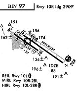
Runways
Runway Summary
| Runways: | 10L/28R 10R/28L |
| Longest Runway: | 10L/28R is 5904 ft (1800 m) long |
| Runways with an Instrument Approach: | 28R |
MOD Airport Runway Details
| Runway 10L/28R | 5904 ft x 150 ft (1800 m x 46 m) | |
| Runway Length Source: | 3RD PARTY SURVEY as of 01/31/2018 | |
| Surface: | Asphalt - Good condition - Saw-cut or plastic grooved | |
| Runway Pavement Class: | 38 /F/C/X/T | |
| Runway Edge Lights: | High Intensity | |
Runway Weight Bearing Capacity (in thousands of pounds) |
||
| Single Wheel Landing Gear: | 60.0 | |
| Dual Wheel Landing Gear: | 200.0 | |
| Dual Tandem Wheel Landing Gear: | 400.0 | |
Runway 10L |
Runway 28R |
|
Elevation: |
99.1 | 81.5 |
Latitude: |
37-37-47.0660N | 37-37-14.3252N |
Longitude: |
120-57-36.3699W | 120-56-35.6196W |
|
Runway True Alignment: |
124 | 304 |
ILS Type: |
ILS | |
Glide Path Angle: |
3.0 degrees | 0.0 degrees |
Traffic Pattern: |
Left | Right |
Runway Markings Type: |
Precision Instrument | Precision Instrument |
Runway Markings Condition: |
Good | Good |
Object at End: |
TREE | ROAD |
Object Height: |
73 | 14 |
Distance from End: |
2700 | 1600 |
Object Centerline Offset: |
450 ft. right of centerline | 0 ft. left and right of centerline |
Visual Glide Slope Indicators: |
4-Box VASI On Left Side Of Runway | |
Approach Light System: |
1,400 Foot Medium Intensity Approach Lighting System With Runway Alignment Indicator Lights | |
REIL: |
Yes | No |
Touchdown Lights: |
No | No |
Centerline Lights: |
No | No |
Threshold Crossing Height: |
50 | |
Declared Distances |
||
Take Off Run Avbl. (TORA): |
5904 | 5904 |
Take Off Distance Avbl. (TODA): |
5904 | 5904 |
Actual Stop Dist. Avbl. (ASDA): |
5904 | 5904 |
Landing Dist. Avbl. (LDA): |
5904 | 5904 |
| Runway 10R/28L | 3464 ft x 100 ft (1056 m x 30 m) | |
| Runway Length Source: | 3RD PARTY SURVEY as of 01/31/2018 | |
| Surface: | Asphalt - Good condition - No special surface treatment | |
| Runway Pavement Class: | 8 /F/C/X/T | |
| Runway Edge Lights: | Medium Intensity | |
Runway Weight Bearing Capacity (in thousands of pounds) |
||
| Single Wheel Landing Gear: | 30.0 | |
Runway 10R |
Runway 28L |
|
Elevation: |
98.4 | 85.8 |
Latitude: |
37-37-46.4443N | 37-37-27.2350N |
Longitude: |
120-57-50.7403W | 120-57-15.0901W |
|
Runway True Alignment: |
124 | 304 |
Glide Path Angle: |
3.5 degrees | 3.0 degrees |
Traffic Pattern: |
Right | Left |
Runway Markings Type: |
Basic | Basic |
Runway Markings Condition: |
Good | Good |
Object at End: |
TREE | TREE |
Object Height: |
56 | 47 |
Distance from End: |
1340 | 1700 |
Object Centerline Offset: |
450 ft. right of centerline | 0 ft. left and right of centerline |
Visual Glide Slope Indicators: |
2-Light PAPI On Left Side Of Runway | 2-Light PAPI On Left Side Of Runway |
REIL: |
No | No |
Touchdown Lights: |
No | No |
Centerline Lights: |
No | No |
Threshold Crossing Height: |
40 | 29 |
Declared Distances |
||
Take Off Run Avbl. (TORA): |
3464 | 3464 |
Take Off Distance Avbl. (TODA): |
3464 | 3464 |
Actual Stop Dist. Avbl. (ASDA): |
3464 | 3464 |
Landing Dist. Avbl. (LDA): |
3464 | 3464 |
Services
Airframe Repair: |
Major |
Powerplant Repair: |
Major |
Bottled Oxygen: |
None |
Bulk Oxygen: |
None |
Fuel Available: |
100LL, Jet A |
Landing Fees: |
No |
Parking: |
Tiedowns available |
Maps & Diagrams
MOD Sectional
Flight Planning
at skyvector.com
at skyvector.com