Location
Latitude: |
33-09-15.2120N (33.154226) |
Longitude: |
083-14-29.0670W (-83.241408) |
Elevation: |
384.9 feet MSL (117 m MSL) |
Magnetic Variation: |
6.2 W (as of April 2024 from WMM2020 model) |
Time Zone: |
UTC -5.0 (Standard Time) UTC -4.0 (Daylight Savings Time) |
From City: |
04 N.M. N of Milledgeville, Georgia |
Found On: |
Atlanta Chart |
FAA Region: |
ASO |
Contacts
Manager: |
Publicly owned: |
| BRUCE HOOD 216 AIRPORT ROAD MILLEDGEVILLE, GA 31061 478-457-4228 |
BALDWIN COUNTY 121 N. WILKINSON STREET, SUITE 314 MILLEDGEVILLE, GA 31061 478-445-4791 |
Operations
Airport Status: |
Operational |
Facility Use: |
Public |
Type: |
Airport |
Activation Date: |
07/1959 |
Control tower: |
No |
Attendance (Months/Days/Hours): |
Months/Days/Hours ALL/MON - SAT/0800-1700 |
Boundary ARTCC: |
ZTL (Atlanta) |
Responsible ARTCC: |
ZTL (Atlanta) |
Lighting Schedule: |
SEE RMK |
Segmented Circle Indicator: |
Yes |
Traffic Pattern Altitude (MSL): |
1385 feet (422 m) |
NOTAMs Facility: |
MCN |
NOTAM-D Service: |
Yes |
International Airport of Entry: |
No |
Customs Landing Rights: |
No |
Military Landing Rights: |
Yes |
Civil/Military Joint Use: |
No |
Based Aircraft
| Single Engine: | 20 |
| Multi Engine: | 4 |
| Jet Engine: | 2 |
Annual Operations (as of 12/31/2022)
| Total Operations: | 10000 | |
| GA Local: | 5100 | 51.0% |
| GA Itinerant: | 4900 | 49.0% |
Communications
| CTAF: | 122.975 |
| Unicom: | 122.975 |
| Approach: | ATLANTA 124.2 124.2 124.2 ATLANTA ARTCC |
| Departure: | ATLANTA 124.2 124.2 124.2 ATLANTA ARTCC |
| AWOS-3: | 120.925 (478-445-7718) |
- ATLANTA LARGE TRACON PROVIDES APCH/DEP SVC 0615-2300 ON FREQ 124.2; ATLANTA ARTCC PROVIDES APCH/DEP SVC 2300-0615 ON FREQS 123.95/269.3 (MACON RCAG).
Fixed Based Operators (FBOs) & Fuel
(Click on a business for detail)
Please help us keep this information up to date. This is a FREE SERVICE just like everything else on Airport Guide! If you see that a business needs to be added, modified, or deleted please fill out our Update Form.
To add, modify, or delete a business click here.
Please help us keep this information up to date. This is a FREE SERVICE just like everything else on Airport Guide! If you see that a business needs to be added, modified, or deleted please fill out our Update Form.
Area Code: 912 |
| Business Name | Frequency | Phone | Fuel Grade |
|---|---|---|---|
| Air Sinclair, Inc.
Update FBO info |
Unicom 122.8 | 453-9358 | 100LL, Jet A |
Flight Service Stations
| Primary | Alternate | |
| FSS on Field: | N | |
| FSS Name (ID): | Macon(MCN) | |
| Frequency: | ||
| Toll Free Phone: | 1-800-WX-BRIEF |
Instrument Procedures / Charts
FAA Terminal Procedures valid from 0901Z 03/21/24 to 0901Z 04/18/24.
There are various types of charts available for an airport. They are listed in the Page Type column. Here is a legend for those types:
APD - Airport Diagram
DP - Departure Procedure Charts
HOT - Hot Spots
IAP - Instrument Approach Procedure Charts
MIN - Minimums
STAR - Standard Terminal Arrival Charts
| Page Type | Page Name | Volume | Action Since Last Cycle |
|---|---|---|---|
| IAP | NDB RWY 28 | SE-4 | |
| IAP | RNAV (GPS) RWY 10 | SE-4 | |
| IAP | RNAV (GPS) RWY 28 | SE-4 | |
| MIN | ALTERNATE MINIMUMS | SE-4 | |
| MIN | TAKEOFF MINIMUMS | SE-4 |
Terminal Procedures are only available for airports in several countries with more being added all the time. If you are looking for a specific country's charts, please send an email to support(at)airportguide.com stating the country name. This will be used to prioritize the implementation.
Navigation Aids (Navaids) near MLJ
| Dist (NM) | ID | Morse Code | Name | Type | Freq | True Hdg | Mag Hdg |
|---|---|---|---|---|---|---|---|
| 4.1 | UMB | . . _ _ _ _ . . . | Culvr | NDB | 380 | 91 | 97 |
| 17.3 | HIT | . . . . . . _ | Kaolin | NDB | 360 | 118 | 124 |
| 31.5 | VV | . . . _ . . . _ | Junne | NDB | 353 | 20 | 26 |
| 34.5 | MCN | _ _ _ . _ . _ . | Macon | DME | 114.2 | 216 | 222 |
| 35.5 | WRB | . _ _ . _ . _ . . . | Robins | TACAN | 135.30 | 209 | 215 |
| 38.8 | AA | . _ . _ | Cedar | NDB | 341 | 53 | 59 |
| 39.3 | VOF | . . . _ _ _ _ . . _ . | Alcovy | NDB | 370 | 316 | 322 |
| 41.1 | DBN | _ . . _ . . . _ . | Dublin | VORTAC | 113.10 | 149 | 155 |
| 41.9 | DB | _ . . _ . . . | Creke | NDB | 251 | 163 | 169 |
| 42.6 | JNM | . _ _ _ _ . _ _ | Monroe | NDB | 392 | 325 | 331 |
| 43.0 | IIY | . . . . _ . _ _ | Washington/Wilkes County | NDB | 435 | 29 | 35 |
| 47.8 | AHN | . _ . . . . _ . | Athens | VOR-DME | 116.95 | 355 | 361 |
| 47.8 | BJT | _ . . . . _ _ _ _ | Bulldog | NDB | 221 | 1 | 7 |
| 49.3 | EEX | . . _ . . _ | Emanuel County | NDB | 309 | 126 | 132 |
| 49.5 | BEP | _ . . . . . _ _ . | Bay Creek | NDB | 350 | 212 | 218 |
| 49.6 | OP | _ _ _ . _ _ . | Yates | NDB | 339 | 253 | 259 |
| 50.0 | BMW | _ . . . _ _ . _ _ | Barrow County | NDB | 404 | 339 | 345 |
| 56.2 | DDA | _ . . _ . . . _ | Commerce | NDB | 244 | 345 | 351 |
| 57.9 | VNA | . . . _ _ . . _ | Vienna | VORTAC | 116.50 | 192 | 198 |
| 60.5 | TX | _ _ . . _ | Gwnet | NDB | 419 | 329 | 335 |
Nearby Airports with Fuel
Notices to Airmen (NOTAMS)
Remarks
| A110-1 | DEER, GEESE, COYOTES, AND BIRDS ON AND INVOF ARPT. |
| A110-10 | RT - REFER TO FBO FOR PRKG. |
| A110-12 | ALL FIXED WING ACFT SHALL LVE PRKG BRAKE OFF IN CASE OF TOWING. |
| A110-13 | NO PUB PRKG AT W RAMP AND HNGRS. |
| A110-2 | FOR CD CTC ATLANTA APCH AT 678-364-6132, WHEN APCH CLSD CTC ATLANTA ARTCC AT 770-210-7692. |
| A110-3 | NO FIXED WING ACFT PRKG WI 100 FT OF FUEL TANK. |
| A110-4 | EXTSV FLT TRNG ON AND INVOF ARPT. |
| A110-5 | FLW FBO INSTRN FOR PRKG DUE TO TIGHT RAMP AREA. |
| A110-6 | BEARS RPRTD W OF RWY, USE CTN. |
| A110-7 | EXTSV BIRD ACT NEAR AER 10/28 FEB TO OCT DRG DALGT HRS. |
| A110-8 | TPA - LIGHT ACFT 1400 MSL, HEAVY ACFT 1900 MSL. |
| A110-9 | AMEL - EXP MARSHALLER UPON ENTERING MAIN RAMP. |
| A16 | ALTN NR: 478-453-9358. |
| A75 | FLW HI WING, LOW WING, HI WING SEQ. |
| A80 | LCTD MID FIELD BESIDE FBO SOUTH OF TWY. |
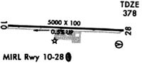
| A81-APT | ATCTVT MALSF RWY 10; REIL RWY 10 & 28; PAPI RWY 10 & 28; MIRL RWY 10/28 ARE PRESET ON MED INTST DUSK-2200; TO INCR INTST AND ACTVT AFTER 2200 - CTAF. |
| A83 | WIND INDCR LCTD N OF RWY 10 TDZ, ACTVT WIND INDCR LGT - CTAF. |
Runways
Runway Summary
| Runways: | 10/28 |
| Longest Runway: | 10/28 is 5506 ft (1678 m) long |
| Runways with an Instrument Approach: |
MLJ Airport Runway Details
| Runway 10/28 | 5506 ft x 100 ft (1678 m x 30 m) | |
| Runway Length Source: | 3RD PARTY SURVEY as of 05/08/2023 | |
| Surface: | Asphalt - Excellent condition - No special surface treatment | |
| Runway Edge Lights: | Medium Intensity | |
Runway Weight Bearing Capacity (in thousands of pounds) |
||
| Single Wheel Landing Gear: | 59.0 | |
| Dual Wheel Landing Gear: | 86.0 | |
Runway 10 |
Runway 28 |
|
Elevation: |
384.9 | 358.7 |
Latitude: |
33-09-16.1556N | 33-09-14.2670N |
Longitude: |
083-15-01.4277W | 083-13-56.7074W |
|
Runway True Alignment: |
092 | 272 |
Glide Path Angle: |
3.0 degrees | 3.0 degrees |
Traffic Pattern: |
Left | Left |
Runway Markings Type: |
Nonprecision Instrument | Nonprecision Instrument |
Runway Markings Condition: |
Good | Good |
Object at End: |
TREES | TREES |
Object Height: |
94 | 47 |
Distance from End: |
3400 | 1798 |
Object Centerline Offset: |
400 ft. left of centerline | 450 ft. right of centerline |
Visual Glide Slope Indicators: |
2-Light PAPI On Left Side Of Runway | 2-Light PAPI On Left Side Of Runway |
Approach Light System: |
1,400 Foot Medium Intensity Approach Lighting System With Sequenced Flashers | |
REIL: |
Yes | Yes |
Touchdown Lights: |
No | No |
Centerline Lights: |
No | No |
Threshold Crossing Height: |
44 | 44 |
Threshold Elevation: |
358.8 | |
Displaced Threshold: |
82 | |
Threshold Latitude: |
33-09-14.2949N | |
Threshold Longitude: |
083-13-57.6700W |
Services
Airframe Repair: |
None |
Powerplant Repair: |
None |
Bottled Oxygen: |
None |
Bulk Oxygen: |
None |
Fuel Available: |
100LL |
Landing Fees: |
No |
Parking: |
Tiedowns available |
Maps & Diagrams
MLJ Sectional
Flight Planning
at skyvector.com
at skyvector.com