Location
Latitude: |
39-00-01.8000N (39.0005) |
Longitude: |
119-45-04.0000W (-119.751111) |
Elevation: |
4723.6 feet MSL (1440 m MSL) |
Magnetic Variation: |
12.8 E (as of April 2024 from WMM2020 model) |
Time Zone: |
UTC -8.0 (Standard Time) UTC -7.0 (Daylight Savings Time) |
From City: |
04 N.M. N of Minden, Nevada |
Found On: |
San Francisco Chart |
FAA Region: |
AWP |
Contacts
Manager: |
Publicly owned: |
| HEATHER MACDONNELL 1146 AIRPORT ROAD MINDEN, NV 89423 775-782-9871 |
DOUGLAS COUNTY P O BOX 218 MINDEN, NV 89423 775-782-9821 |
Operations
Airport Status: |
Operational |
Facility Use: |
Public |
Type: |
Airport |
Activation Date: |
12/1942 |
Control tower: |
No |
Attendance (Months/Days/Hours): |
Months/Days/Hours ALL/ALL/0800-1700 |
Boundary ARTCC: |
ZOA (Oakland) |
Responsible ARTCC: |
ZOA (Oakland) |
Lighting Schedule: |
SEE RMK |
Segmented Circle Indicator: |
Yes |
Traffic Pattern Altitude (MSL): |
5724 feet (1745 m) |
NOTAMs Facility: |
MEV |
NOTAM-D Service: |
Yes |
International Airport of Entry: |
No |
Customs Landing Rights: |
No |
Military Landing Rights: |
No |
Civil/Military Joint Use: |
No |
Based Aircraft
| Single Engine: | 141 |
| Multi Engine: | 22 |
| Jet Engine: | 6 |
| GA Helicopters: | 8 |
| Gliders: | 94 |
| Ultralights: | 1 |
Annual Operations (as of 05/10/2023)
| Total Operations: | 90920 | |
| Air Taxi: | 2607 | 2.9% |
| GA Local: | 42210 | 46.4% |
| GA Itinerant: | 45741 | 50.3% |
| Military Aircraft: | 362 | 0.4% |
Communications
| CTAF: | 123.050 |
| Unicom: | 123.050 |
| Approach: | NORCAL 119.2 119.2 119.2 |
| Departure: | NORCAL 119.2 119.2 119.2 |
| AWOS-3PT: | 119.325 (775-782-6264) |
Fixed Based Operators (FBOs) & Fuel
(Click on a business for detail)
Please help us keep this information up to date. This is a FREE SERVICE just like everything else on Airport Guide! If you see that a business needs to be added, modified, or deleted please fill out our Update Form.
To add, modify, or delete a business click here.
Please help us keep this information up to date. This is a FREE SERVICE just like everything else on Airport Guide! If you see that a business needs to be added, modified, or deleted please fill out our Update Form.
Area Code: 775 |
| Business Name | Frequency | Phone | Fuel Grade |
|---|---|---|---|
| Air Sierra Unlimited, Inc.
Update FBO info |
782-4854 | ||
| Chaparral Avionics
Update FBO info |
782-4587 | ||
| Flying Start Aero
Update FBO info |
783-8359 | ||
| GFA Aircraft Sales
Update FBO info |
267-1800 | ||
| High Country Soaring
Update FBO info |
782-4944 | ||
| Hutt Aviation
Update FBO info |
Unicom 122.8 | 782-8277 | 100LL, Jet A |
| Minden Aircraft Repair
Update FBO info |
782-7574 | ||
| NIFTI
Update FBO info |
782-4381 | ||
| Rebuilt Aircraft and Salvage
Update FBO info |
782-5282 | ||
| Soar Minden
Update FBO info |
782-7627 | 100LL | |

|
Chevron |
100LL - 2.26 USD per gallon on 10/13/01 |
Trucks |
Flight Service Stations
| Primary | Alternate | |
| FSS on Field: | N | |
| FSS Name (ID): | Reno(RNO) | |
| Frequency: | ||
| Toll Free Phone: | 1-800-WX-BRIEF |
Instrument Procedures / Charts
FAA Terminal Procedures valid from 0901Z 03/21/24 to 0901Z 04/18/24.
There are various types of charts available for an airport. They are listed in the Page Type column. Here is a legend for those types:
APD - Airport Diagram
DP - Departure Procedure Charts
HOT - Hot Spots
IAP - Instrument Approach Procedure Charts
MIN - Minimums
STAR - Standard Terminal Arrival Charts
| Page Type | Page Name | Volume | Action Since Last Cycle |
|---|---|---|---|
| APD | AIRPORT DIAGRAM | SW-4 | |
| HOT | HOT SPOT | SW-4 | |
| IAP | RNAV (GPS) RWY 16 | SW-4 | |
| IAP | RNAV (GPS) RWY 34 | SW-4 | |
| MIN | ALTERNATE MINIMUMS | SW-4 | |
| MIN | TAKEOFF MINIMUMS | SW-4 | |
| ODP | MINDEN TWO (OBSTACLE) (RNAV) | SW-4 |
Terminal Procedures are only available for airports in several countries with more being added all the time. If you are looking for a specific country's charts, please send an email to support(at)airportguide.com stating the country name. This will be used to prioritize the implementation.
Navigation Aids (Navaids) near MEV
| Dist (NM) | ID | Morse Code | Name | Type | Freq | True Hdg | Mag Hdg |
|---|---|---|---|---|---|---|---|
| 26.4 | SWR | . . . . _ _ . _ . | Squaw Valley | VOR-DME | 113.20 | 294 | 281 |
| 32.2 | FMG | . . _ . _ _ _ _ . | Mustang | VORTAC | 117.90 | 7 | 354 |
| 46.7 | HZN | . . . . _ _ . . _ . | Hazen | VORTAC | 114.10 | 48 | 35 |
| 49.5 | HNW | . . . . _ . . _ _ | Hangtown | VOR-DME | 115.50 | 250 | 237 |
| 54.7 | NFL | _ . . . _ . . _ . . | Fallon | TACAN | 113.50 | 62 | 49 |
| 78.3 | AHC | . _ . . . . _ . _ . | Amedee | VOR-DME | 109.00 | 346 | 333 |
| 79.1 | BAB | _ . . . . _ _ . . . | Beale | TACAN | 108.60 | 276 | 263 |
| 79.8 | MCC | _ _ _ . _ . _ . _ . | Mc Clellan | VOR-DME | 109.20 | 256 | 243 |
| 80.9 | LIN | . _ . . . . _ . | Linden | VOR-DME | 114.80 | 227 | 214 |
| 84.5 | MVA | _ _ . . . _ . _ | Mina | VORTAC | 115.10 | 107 | 94 |
| 85.1 | MYV | _ _ _ . _ _ . . . _ | Marysville | VOR-DME | 110.80 | 274 | 261 |
| 86.6 | LLC | . _ . . . _ . . _ . _ . | Lovelock | VORTAC | 116.50 | 38 | 25 |
| 86.7 | SAC | . . . . _ _ . _ . | Sacramento Executive | VOT | 111.40 | 250 | 237 |
| 87.2 | MY | _ _ _ . _ _ | Halow | NDB | 222 | 277 | 264 |
| 88.0 | SMF | . . . _ _ . . _ . | Sacramento Intl | VOT | 111.40 | 258 | 245 |
| 90.7 | SAC | . . . . _ _ . _ . | Sacramento | VORTAC | 115.20 | 248 | 235 |
| 96.7 | ECA | . _ . _ . . _ | Manteca | VOR-DME | 116.00 | 224 | 211 |
Nearby Airports with Fuel
Notices to Airmen (NOTAMS)
Remarks
| A110-13 | GLIDER, ULTRALIGHT, SKYDIVING, SAILPLANE AND BALLOON ACT ON AND INVOF ARPT. |
| A110-16 | EMERG AFT 1700 - 775-782-5126. |
| A110-17 | SNOW REMOVAL DURG DALGT ONLY. |
| A110-19 | NOISE ABATEMENT PROC IN EFCT - 775-782-9871. |
| A110-21 | TREES 1,440 FT FROM APCH END RY 12. DITCH IN OBSTACLE FREE ZONE ADJ SW END TWY C. MEN & EQUIPMENT OCCASIONLY ON RWYS AND TWYS. |
| A110-23 | MOWERS INVOF ARPT & RWYS. |
| A110-25 | FOR CD CTC NORCAL APCH AT 916-361-6874. |
| A30-12G/30G | RWY 30G LNDG ONLY; RWY 12G TKOF & LNDG NA. |
| A30A-30 | SAILPLANE PAT RT TFC. |
| A30A-34 | SAILPLANE PAT RT TFC. |
| A39-12/30 | PCR VALUE: 10/F/C/X/T |
| A39-16/34 | PCR VALUE: 40/F/C/X/T |
| A42-30G | THR MKD WITH ORANGE & WHITE PANELS. |
| A81-APT | ACTVT REIL RWY 16 & 34; VASI RWY 16 & 34; HIRL RWY 16/34 - CTAF. |
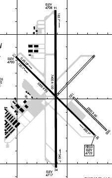
Runways
Runway Summary
| Runways: | 12/30 12G/30G 16/34 |
| Longest Runway: | 16/34 is 7399 ft (2255 m) long |
| Runways with an Instrument Approach: |
MEV Airport Runway Details
| Runway 12/30 | 5299 ft x 75 ft (1615 m x 23 m) | |
| Runway Length Source: | 3RD PARTY SURVEY as of 10/01/2015 | |
| Surface: | Asphalt - Good condition - No special surface treatment | |
Runway Weight Bearing Capacity (in thousands of pounds) |
||
| Single Wheel Landing Gear: | 50.0 | |
| Dual Wheel Landing Gear: | 75.0 | |
Runway 12 |
Runway 30 |
|
Elevation: |
4700.2 | 4722.1 |
Latitude: |
39-00-19.7592N | 38-59-42.8668N |
Longitude: |
119-45-30.7566W | 119-44-43.1385W |
|
Runway True Alignment: |
135 | 315 |
Glide Path Angle: |
0.0 degrees | 0.0 degrees |
Traffic Pattern: |
Right | Left |
Runway Markings Type: |
Basic | Basic |
Runway Markings Condition: |
Good | Good |
Object at End: |
TREE | |
Object Height: |
60 | |
Distance from End: |
1430 | |
Object Centerline Offset: |
30 ft. left of centerline | |
REIL: |
No | No |
Touchdown Lights: |
No | No |
Centerline Lights: |
No | No |
| Runway 12G/30G | 2050 ft x 60 ft (625 m x 18 m) | |
| Runway Length Source: | 3RD PARTY SURVEY as of 10/01/2015 | |
| Surface: | Asphalt - Good condition - No special surface treatment | |
Runway 12G |
Runway 30G |
|
Elevation: |
4712.4 | 4723.6 |
Latitude: |
38-59-59.6714N | 38-59-45.3969N |
Longitude: |
119-44-54.9291W | 119-44-36.5094W |
|
Runway True Alignment: |
135 | 315 |
Glide Path Angle: |
0.0 degrees | 0.0 degrees |
Runway Markings Type: |
None | |
Object Height: |
2 | |
Distance from End: |
66 | |
Object Centerline Offset: |
30 ft. left of centerline | |
REIL: |
No |
| Runway 16/34 | 7399 ft x 100 ft (2255 m x 30 m) | |
| Runway Length Source: | 3RD PARTY SURVEY as of 10/01/2015 | |
| Surface: | Asphalt - Good condition - No special surface treatment | |
| Runway Edge Lights: | High Intensity | |
Runway Weight Bearing Capacity (in thousands of pounds) |
||
| Single Wheel Landing Gear: | 50.0 | |
| Dual Wheel Landing Gear: | 75.0 | |
Runway 16 |
Runway 34 |
|
Elevation: |
4707.7 | 4717.2 |
Latitude: |
39-00-41.3162N | 38-59-28.2010N |
Longitude: |
119-45-07.1268W | 119-45-06.7818W |
|
Runway True Alignment: |
180 | 360 |
Glide Path Angle: |
3.0 degrees | 3.0 degrees |
Traffic Pattern: |
Right | Left |
Runway Markings Type: |
Nonprecision Instrument | Nonprecision Instrument |
Runway Markings Condition: |
Good | Good |
Object Centerline Offset: |
30 ft. left of centerline | |
Visual Glide Slope Indicators: |
4-Box VASI On Right Side Of Runway | 4-Box VASI On Left Side Of Runway |
REIL: |
Yes | Yes |
Touchdown Lights: |
No | No |
Centerline Lights: |
No | No |
Threshold Crossing Height: |
40 | 31 |
Services
Airframe Repair: |
Major |
Powerplant Repair: |
Major |
Fuel Available: |
100LL |
Landing Fees: |
No |
Parking: |
Tiedowns available |
Other Services: |
Aircraft modifications |
Maps & Diagrams
MEV Sectional
Flight Planning
at skyvector.com
at skyvector.com