Location
Latitude: |
35-48-07.8600N (35.802183) |
Longitude: |
088-52-29.7640W (-88.874934) |
Elevation: |
421.2 feet MSL (128 m MSL) |
Magnetic Variation: |
2.7 W (as of April 2024 from WMM2020 model) |
Time Zone: |
UTC -6.0 (Standard Time) UTC -5.0 (Daylight Savings Time) |
From City: |
03 N.M. SE of Humboldt, Tennessee |
Found On: |
Memphis Chart |
FAA Region: |
ASO |
Contacts
Manager: |
Publicly owned: |
| CHUCK LOVELL 4655 EAST MAIN ST HUMBOLDT, TN 38343 731-618-9089 |
CITY OF HUMBOLDT 1201 MAIN STREET HUMBOLDT, TN 38343 731-784-2511 |
Operations
Airport Status: |
Operational |
Facility Use: |
Public |
Type: |
Airport |
Activation Date: |
12/1946 |
Control tower: |
No |
Attendance (Months/Days/Hours): |
Months/Days/Hours ALL/MON-FRI/0730-1630 |
Boundary ARTCC: |
ZME (Memphis) |
Responsible ARTCC: |
ZME (Memphis) |
Lighting Schedule: |
SS-SR |
Segmented Circle Indicator: |
Yes |
Traffic Pattern Altitude (MSL): |
1421 feet (433 m) |
NOTAMs Facility: |
MKL |
NOTAM-D Service: |
Yes |
International Airport of Entry: |
No |
Customs Landing Rights: |
No |
Military Landing Rights: |
Yes |
Civil/Military Joint Use: |
No |
Based Aircraft
| Single Engine: | 11 |
| Multi Engine: | 2 |
Annual Operations (as of 08/12/2020)
| Total Operations: | 2326 | |
| Air Taxi: | 4 | 0.2% |
| GA Local: | 2072 | 89.1% |
| GA Itinerant: | 250 | 10.7% |
Communications
| CTAF: | 122.800 |
| Unicom: | 122.800 |
- APCH/DEP SVC PRVDD BY MEMPHIS ARTCC ON FREQS 134.65/316.15 (MCKELLAR RCAG).
Fixed Based Operators (FBOs) & Fuel
(Click on a business for detail)
Please help us keep this information up to date. This is a FREE SERVICE just like everything else on Airport Guide! If you see that a business needs to be added, modified, or deleted please fill out our Update Form.
To add, modify, or delete a business click here.
Please help us keep this information up to date. This is a FREE SERVICE just like everything else on Airport Guide! If you see that a business needs to be added, modified, or deleted please fill out our Update Form.
Area Code: 731 |
| Business Name | Frequency | Phone | Fuel Grade |
|---|
Flight Service Stations
| Primary | Alternate | |
| FSS on Field: | N | |
| FSS Name (ID): | Jackson(MKL) | |
| Frequency: | ||
| Toll Free Phone: | 1-800-WX-BRIEF |
Instrument Procedures / Charts
FAA Terminal Procedures valid from 0901Z 03/21/24 to 0901Z 04/18/24.
There are various types of charts available for an airport. They are listed in the Page Type column. Here is a legend for those types:
APD - Airport Diagram
DP - Departure Procedure Charts
HOT - Hot Spots
IAP - Instrument Approach Procedure Charts
MIN - Minimums
STAR - Standard Terminal Arrival Charts
| Page Type | Page Name | Volume | Action Since Last Cycle |
|---|---|---|---|
| IAP | RNAV (GPS) RWY 04 | SE-1 | |
| IAP | RNAV (GPS) RWY 22 | SE-1 | |
| MIN | TAKEOFF MINIMUMS | SE-1 |
Terminal Procedures are only available for airports in several countries with more being added all the time. If you are looking for a specific country's charts, please send an email to support(at)airportguide.com stating the country name. This will be used to prioritize the implementation.
Navigation Aids (Navaids) near M53
| Dist (NM) | ID | Morse Code | Name | Type | Freq | True Hdg | Mag Hdg |
|---|---|---|---|---|---|---|---|
| 12.0 | MKL | _ _ _ . _ . _ . . | Mc Kellar | VOR-DME | 112.00 | 188 | 191 |
| 17.6 | MKL | _ _ _ . _ . _ . . | Mersy | NDB | 394 | 193 | 196 |
| 25.1 | DYR | _ . . _ . _ _ . _ . | Dyersburg | TACAN | 116.80 | 301 | 304 |
| 26.2 | HZD | . . . . _ _ . . _ . . | Huntingdon | NDB | 217 | 48 | 51 |
| 27.9 | JKS | . _ _ _ _ . _ . . . | Jacks Creek | VOR-DME | 109.40 | 115 | 118 |
| 30.3 | UC | . . _ _ . _ . | Obion | NDB | 212 | 348 | 351 |
| 34.9 | TIQ | _ . . _ _ . _ | Trainer | NDB | 410 | 39 | 42 |
| 37.0 | COO | _ . _ . _ _ _ _ _ _ | Covington | NDB | 326 | 250 | 252 |
| 38.2 | SZY | . . . _ _ . . _ . _ _ | Sibley | NDB | 386 | 152 | 155 |
| 43.8 | FYE | . . _ . _ . _ _ . | Somerville | NDB | 255 | 215 | 217 |
| 48.9 | UU | . . _ . . _ | Seyer | NDB | 334 | 164 | 167 |
| 52.6 | GOJ | _ _ . _ _ _ . _ _ _ | Gosnell | VOR | 111.80 | 280 | 282 |
| 58.2 | AEY | . _ . _ . _ _ | Waverly | NDB | 329 | 70 | 73 |
| 60.4 | MIG | _ _ . . _ _ . | Millington | NDB | 232 | 239 | 241 |
| 62.0 | EU | . . . _ | Murey | NDB | 368 | 27 | 30 |
| 64.0 | JHG | . _ _ _ . . . . _ _ . | Hohenwald | NDB | 257 | 108 | 111 |
| 66.8 | CHQ | _ . _ . . . . . _ _ . _ | Charleston | NDB | 208 | 339 | 342 |
| 67.5 | MAW | _ _ . _ . _ _ | Malden | TACAN | 111.20 | 312 | 314 |
| 67.8 | SPQ | . . . . _ _ . _ _ . _ | Spain | NDB | 414 | 238 | 240 |
| 69.0 | HLI | . . . . . _ . . . . | Holly Springs | VORTAC | 112.40 | 206 | 208 |
Nearby Airports with Fuel
Notices to Airmen (NOTAMS)
Remarks
| A110-2 | AGRICULTURAL ACFT OPS ON & INVOF ARPT. |
| A110-3 | FOR CD CTC MEMPHIS ARTCC AT 901-368-8453/8449. |
| A110-4 | PILOT ENTRANCE CODE 1228. |
| A110-5 | 24/7 CREDIT CARD FUEL AVBL. |
| A30-04/22 | 15-30 FT TREES W OF RWY VIOLATE TRANSITION SLOPE. |
Runways
Runway Summary
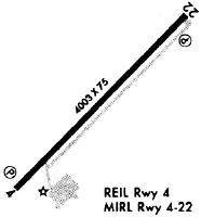
| Runways: | 04/22 |
| Longest Runway: | 04/22 is 4003 ft (1220 m) long |
| Runways with an Instrument Approach: |
M53 Airport Runway Details
| Runway 04/22 | 4003 ft x 75 ft (1220 m x 23 m) | |
| Runway Length Source: | 3RD PARTY SURVEY as of 10/15/2022 | |
| Surface: | Asphalt - Fair condition - No special surface treatment | |
| Runway Edge Lights: | Medium Intensity | |
Runway Weight Bearing Capacity (in thousands of pounds) |
||
| Single Wheel Landing Gear: | 16.0 | |
| Dual Wheel Landing Gear: | 26.0 | |
Runway 04 |
Runway 22 |
|
Elevation: |
407.0 | 421.1 |
Latitude: |
35-47-53.7177N | 35-48-22.0014N |
Longitude: |
088-52-46.7670W | 088-52-12.7604W |
|
Runway True Alignment: |
044 | 224 |
Glide Path Angle: |
3.0 degrees | 3.0 degrees |
Traffic Pattern: |
Left | Left |
Runway Markings Type: |
Nonprecision Instrument | Nonprecision Instrument |
Runway Markings Condition: |
Fair | Fair |
Object at End: |
TREES | TREES |
Object Height: |
72 | 49 |
Distance from End: |
671 | 629 |
Object Centerline Offset: |
496 ft. right of centerline | 627 ft. right of centerline |
Visual Glide Slope Indicators: |
2-Light PAPI On Left Side Of Runway | 2-Light PAPI On Left Side Of Runway |
REIL: |
Yes | Yes |
Threshold Crossing Height: |
30 | 26 |
Services
Airframe Repair: |
Major |
Powerplant Repair: |
Major |
Bottled Oxygen: |
None |
Bulk Oxygen: |
None |
Fuel Available: |
100LL, Jet A |
Landing Fees: |
No |
Parking: |
Tiedowns available |
Maps & Diagrams
M53 Sectional
Flight Planning
at skyvector.com
at skyvector.com