Location
Latitude: |
36-01-24.0550N (36.023349) |
Longitude: |
078-19-48.9470W (-78.330263) |
Elevation: |
368.0 feet MSL (112 m MSL) |
Magnetic Variation: |
9.6 W (as of April 2024 from WMM2020 model) |
Time Zone: |
UTC -5.0 (Standard Time) UTC -4.0 (Daylight Savings Time) |
From City: |
05 N.M. SW of Louisburg, North Carolina |
Found On: |
Charlotte Chart |
FAA Region: |
ASO |
Contacts
Manager: |
Publicly owned: |
| BO CARSON 440 AIRPORT DRIVE LOUISBURG, NC 27549 919-496-1234 |
FRANKLIN COUNTY 113 MARKET STREET LOUISBURG, NC 27549 919-554-1863 |
Operations
Airport Status: |
Operational |
Facility Use: |
Public |
Type: |
Airport |
Activation Date: |
03/1993 |
Control tower: |
No |
Attendance (Months/Days/Hours): |
Months/Days/Hours ALL/ALL/0800-1800 |
Boundary ARTCC: |
ZDC (Washington) |
Responsible ARTCC: |
ZDC (Washington) |
Lighting Schedule: |
SEE RMK |
Segmented Circle Indicator: |
Yes |
Traffic Pattern Altitude (MSL): |
1368 feet (417 m) |
NOTAMs Facility: |
LHZ |
NOTAM-D Service: |
Yes |
Based Aircraft
| Single Engine: | 89 |
| Multi Engine: | 3 |
| Jet Engine: | 1 |
| GA Helicopters: | 7 |
| Gliders: | 5 |
Annual Operations (as of 07/01/2023)
| Total Operations: | 62800 | |
| GA Local: | 42300 | 67.4% |
| GA Itinerant: | 18000 | 28.7% |
| Military Aircraft: | 2500 | 4.0% |
Communications
| CTAF: | 123.000 |
| Unicom: | 123.000 |
| Approach: | RALEIGH 125.3 125.3 |
| Departure: | RALEIGH 125.3 125.3 |
| AWOS-3: | 118.325 (919-497-0810) |
Fixed Based Operators (FBOs) & Fuel
(Click on a business for detail)
Please help us keep this information up to date. This is a FREE SERVICE just like everything else on Airport Guide! If you see that a business needs to be added, modified, or deleted please fill out our Update Form.
To add, modify, or delete a business click here.
Please help us keep this information up to date. This is a FREE SERVICE just like everything else on Airport Guide! If you see that a business needs to be added, modified, or deleted please fill out our Update Form.
Area Code: 919 |
| Business Name | Frequency | Phone | Fuel Grade |
|---|---|---|---|
| First In Flight Aviation
Update FBO info |
Unicom 123.0 | 496-1234 | 100LL, Jet A |
Flight Service Stations
| Primary | Alternate | |
| FSS on Field: | N | |
| FSS Name (ID): | Raleigh(RDU) | |
| Frequency: | ||
| Toll Free Phone: | 1-800-WX-BRIEF |
Instrument Procedures / Charts
FAA Terminal Procedures valid from 0901Z 03/21/24 to 0901Z 04/18/24.
There are various types of charts available for an airport. They are listed in the Page Type column. Here is a legend for those types:
APD - Airport Diagram
DP - Departure Procedure Charts
HOT - Hot Spots
IAP - Instrument Approach Procedure Charts
MIN - Minimums
STAR - Standard Terminal Arrival Charts
| Page Type | Page Name | Volume | Action Since Last Cycle |
|---|---|---|---|
| IAP | ILS OR LOC RWY 05 | SE-2 | |
| IAP | RNAV (GPS) RWY 05 | SE-2 | |
| IAP | RNAV (GPS) RWY 23 | SE-2 | |
| IAP | VOR-A | SE-2 | |
| MIN | ALTERNATE MINIMUMS | SE-2 | |
| MIN | TAKEOFF MINIMUMS | SE-2 |
Terminal Procedures are only available for airports in several countries with more being added all the time. If you are looking for a specific country's charts, please send an email to support(at)airportguide.com stating the country name. This will be used to prioritize the implementation.
Navigation Aids (Navaids) near LFN
| Dist (NM) | ID | Morse Code | Name | Type | Freq | True Hdg | Mag Hdg |
|---|---|---|---|---|---|---|---|
| 19.9 | LE | . _ . . . | Leevy | NDB | 350 | 253 | 262 |
| 21.7 | HXO | . . . . _ . . _ _ _ _ | Huntsboro | NDB | 271 | 320 | 330 |
| 23.8 | RDU | . _ . _ . . . . _ | Raleigh/Durham | VORTAC | 117.20 | 247 | 256 |
| 30.5 | TYI | _ _ . _ _ . . | Tar River | VORTAC | 117.80 | 95 | 105 |
| 33.2 | JN | . _ _ _ _ . | Jurly | NDB | 263 | 188 | 198 |
| 37.8 | HUR | . . . . . . _ . _ . | Person | NDB | 220 | 289 | 298 |
| 37.9 | AEA | . _ . . _ | Jones | NDB | 373 | 20 | 30 |
| 38.4 | ETC | . _ _ . _ . | Tarboro | NDB | 257 | 97 | 107 |
| 39.2 | RZZ | . _ . _ _ . . _ _ . . | Rapids | NDB | 407 | 50 | 60 |
| 39.2 | HQT | . . . . _ _ . _ _ | Harnett | NDB | 417 | 205 | 214 |
| 42.3 | MBV | _ _ _ . . . . . . _ | Mecklenburg/Dcmsnd | NDB | 356 | 18 | 28 |
| 44.8 | GSB | _ _ . . . . _ . . . | Seymour Johnson | TACAN | 116.50 | 156 | 166 |
| 50.3 | AQE | . _ _ _ . _ . | Alwood | NDB | 230 | 111 | 121 |
| 50.5 | TT | _ _ | Leeco | NDB | 406 | 231 | 240 |
| 51.2 | SBV | . . . _ . . . . . . _ | South Boston | VORTAC | 110.40 | 319 | 328 |
| 51.5 | PGV | . _ _ . _ _ . . . . _ | Belvoir | FAN MARKER | 116 | 126 | |
| 52.0 | LVL | . _ . . . . . _ . _ . . | Lawrenceville | VORTAC | 112.90 | 23 | 33 |
| 54.3 | ISO | . . . . . _ _ _ | Kinston | VORTAC | 117.50 | 135 | 145 |
| 56.0 | IS | . . . . . | Stals | NDB | 276 | 146 | 156 |
| 56.4 | ELQ | . . _ . . _ _ . _ | Emporia | NDB | 261 | 50 | 60 |
Nearby Airports with Fuel
Notices to Airmen (NOTAMS)
Remarks
| A110-1 | ARPT PHONE 919-496-1234; MAKE PRIOR ARNGMTS DRG FBO HOURS FOR SVCS AFTER HOURS. |
| A110-2 | BIRDS ON & INVOF ARPT. |
| A110-5 | HEL FLIGHT TNG DAILY PRIMRLY ON W SIDE OF ARPT AND TWY. |
| A110-6 | DAILY SKYDIVING OPS. |
| A110-7 | GLIDER ACT DALGT HRS WKENDS. |
| A110-8 | FOR CD CTC RALEIGH APCH AT 919-380-3144. |
| A17 | ARPT UNATNDD THANKSGIVING & CHRISTMAS. |
| A58-23 | 2 FT RISING GND 157 FT FM THR BOTH SIDES OF CNTRLN. |
| A81-APT | ACTVT MALSR RWY 05; REIL RWY 23; HIRL RWY 05/23 - CTAF. PAPI RWY 05 & 23 OPER CONSLY. |
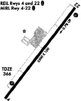
Runways
Runway Summary
| Runways: | 05/23 |
| Longest Runway: | 05/23 is 5498 ft (1676 m) long |
| Runways with an Instrument Approach: | 05 |
LFN Airport Runway Details
| Runway 05/23 | 5498 ft x 100 ft (1676 m x 30 m) | |
| Runway Length Source: | 3RD PARTY SURVEY as of 05/31/2018 | |
| Surface: | Asphalt - Excellent condition - Saw-cut or plastic grooved | |
| Runway Edge Lights: | High Intensity | |
Runway Weight Bearing Capacity (in thousands of pounds) |
||
| Single Wheel Landing Gear: | 40.0 | |
| Dual Wheel Landing Gear: | 60.0 | |
Runway 05 |
Runway 23 |
|
Elevation: |
367.9 | 328.8 |
Latitude: |
36-01-02.4808N | 36-01-45.6288N |
Longitude: |
078-20-09.3096W | 078-19-28.5819W |
|
Runway True Alignment: |
037 | 217 |
ILS Type: |
ILS/DME | |
Glide Path Angle: |
3.0 degrees | 3.0 degrees |
Traffic Pattern: |
Right | |
Runway Markings Type: |
Precision Instrument | Nonprecision Instrument |
Runway Markings Condition: |
Good | Good |
Object at End: |
TREES | TREES |
Object Height: |
41 | 41 |
Distance from End: |
1640 | 1537 |
Object Centerline Offset: |
352 ft. left of centerline | 502 ft. left of centerline |
Visual Glide Slope Indicators: |
4-Light PAPI On Left Side Of Runway | 4-Light PAPI On Left Side Of Runway |
Approach Light System: |
1,400 Foot Medium Intensity Approach Lighting System With Runway Alignment Indicator Lights | |
REIL: |
No | Yes |
Threshold Crossing Height: |
42 | 49 |
Services
Airframe Repair: |
None |
Powerplant Repair: |
None |
Bottled Oxygen: |
None |
Bulk Oxygen: |
High Pressure |
Fuel Available: |
100LL, Jet A-1+ |
Landing Fees: |
No |
Parking: |
Tiedowns available |
Maps & Diagrams
LFN Sectional
Flight Planning
at skyvector.com
at skyvector.com