Location
Latitude: |
37-36-14.4000N (37.604) |
Longitude: |
101-22-24.8000W (-101.373556) |
Elevation: |
3071.0 feet MSL (936 m MSL) |
Magnetic Variation: |
5.5 E (as of April 2024 from WMM2020 model) |
Time Zone: |
UTC -6.0 (Standard Time) UTC -5.0 (Daylight Savings Time) |
From City: |
01 N.M. N of Ulysses, Kansas |
Found On: |
Wichita Chart |
FAA Region: |
ACE |
Contacts
Manager: |
Publicly owned: |
| STEVE RICE PO BOX 412 ULYSSES, KS 67880 620-952-0954 |
GRANT COUNTY 108 S GLENN ULYSSES, KS 67880 620-356-1335 |
Operations
Airport Status: |
Operational |
Facility Use: |
Public |
Type: |
Airport |
Activation Date: |
02/1947 |
Control tower: |
No |
Attendance (Months/Days/Hours): |
Months/Days/Hours ALL/MON-SAT/0800-1800 |
Boundary ARTCC: |
ZKC (Kansas City) |
Responsible ARTCC: |
ZKC (Kansas City) |
Lighting Schedule: |
SEE RMK |
Segmented Circle Indicator: |
No |
Traffic Pattern Altitude (MSL): |
4071 feet (1241 m) |
NOTAMs Facility: |
ICT |
NOTAM-D Service: |
Yes |
International Airport of Entry: |
No |
Customs Landing Rights: |
No |
Military Landing Rights: |
Yes |
Civil/Military Joint Use: |
No |
Based Aircraft
| Single Engine: | 26 |
| Multi Engine: | 5 |
| GA Helicopters: | 1 |
| Gliders: | 4 |
Annual Operations (as of 08/28/2019)
| Total Operations: | 21500 | |
| Air Taxi: | 400 | 1.9% |
| GA Local: | 15100 | 70.2% |
| GA Itinerant: | 6000 | 27.9% |
Communications
| CTAF: | 122.800 |
| Unicom: | 122.800 |
| AWOS-3PT: | 118.95 (620-424-3747) |
- APCH/DEP CTL SVC PRVDD BY KANSAS CITY ARTCC (ZKC) ON 125.2/285.425 (GARDEN CITY RCAG).
Fixed Based Operators (FBOs) & Fuel
(Click on a business for detail)
Please help us keep this information up to date. This is a FREE SERVICE just like everything else on Airport Guide! If you see that a business needs to be added, modified, or deleted please fill out our Update Form.
To add, modify, or delete a business click here.
Please help us keep this information up to date. This is a FREE SERVICE just like everything else on Airport Guide! If you see that a business needs to be added, modified, or deleted please fill out our Update Form.
Area Code: 620 |
| Business Name | Frequency | Phone | Fuel Grade |
|---|---|---|---|
| Moyer Aviation, Inc.
Update FBO info |
356-3554 | ||
| Ulysses Aero Center, L.L.C.
Update FBO info |
Unicom 122.8 | 356-2000 | 100LL, Jet A |
Flight Service Stations
| Primary | Alternate | |
| FSS on Field: | N | |
| FSS Name (ID): | Wichita(ICT) | |
| Frequency: | ||
| Toll Free Phone: | 1-800-WX-BRIEF |
Instrument Procedures / Charts
FAA Terminal Procedures valid from 0901Z 03/21/24 to 0901Z 04/18/24.
There are various types of charts available for an airport. They are listed in the Page Type column. Here is a legend for those types:
APD - Airport Diagram
DP - Departure Procedure Charts
HOT - Hot Spots
IAP - Instrument Approach Procedure Charts
MIN - Minimums
STAR - Standard Terminal Arrival Charts
| Page Type | Page Name | Volume | Action Since Last Cycle |
|---|---|---|---|
| IAP | RNAV (GPS) RWY 12 | NC-2 | |
| IAP | RNAV (GPS) RWY 17 | NC-2 | |
| IAP | RNAV (GPS) RWY 30 | NC-2 | |
| IAP | RNAV (GPS) RWY 35 | NC-2 | |
| MIN | ALTERNATE MINIMUMS | NC-2 | |
| MIN | TAKEOFF MINIMUMS | NC-2 |
Terminal Procedures are only available for airports in several countries with more being added all the time. If you are looking for a specific country's charts, please send an email to support(at)airportguide.com stating the country name. This will be used to prioritize the implementation.
Navigation Aids (Navaids) near KULS
| Dist (NM) | ID | Morse Code | Name | Type | Freq | True Hdg | Mag Hdg |
|---|---|---|---|---|---|---|---|
| 0.5 | ULS | . . _ . _ . . . . . | Ulysses | NDB | 395 | 147 | 142 |
| 17.3 | JHN | . _ _ _ . . . . _ . | Bear Creek | NDB | 341 | 276 | 270 |
| 26.4 | HQG | . . . . _ _ . _ _ _ . | Hugoton | NDB | 365 | 180 | 175 |
| 33.6 | GC | _ _ . _ . _ . | Pieve | NDB | 347 | 66 | 61 |
| 36.1 | GCK | _ _ . _ . _ . _ . _ | Garden City | VORTAC | 113.30 | 58 | 53 |
| 38.7 | LBL | . _ . . _ . . . . _ . . | Liberal | TACAN | 112.30 | 150 | 145 |
| 43.2 | LB | . _ . . _ . . . | Panck | NDB | 383 | 152 | 147 |
| 43.6 | EHA | . . . . . . _ | Elkhart | NDB | 377 | 214 | 208 |
| 54.3 | GUY | _ _ . . . _ _ . _ _ | Guymon | NDB | 275 | 186 | 181 |
| 57.3 | TQK | _ _ _ . _ _ . _ | Scott City | NDB | 256 | 23 | 18 |
| 66.6 | DDC | _ . . _ . . _ . _ . | Dodge City | VORTAC | 108.20 | 76 | 71 |
| 71.7 | LAA | . _ . . . _ . _ | Lamar | VOR-DME | 116.90 | 300 | 294 |
| 77.5 | PYX | . _ _ . _ . _ _ _ . . _ | Perryton | NDB | 266 | 157 | 152 |
| 94.2 | OEL | _ _ _ . . _ . . | Oakley | NDB | 380 | 16 | 11 |
| 94.8 | BFK | _ . . . . . _ . _ . _ | Buffalo | NDB | 215 | 117 | 112 |
Nearby Airports with Fuel
| Dist (NM) | Name (Airport IDs) | True Hdg | Mag Hdg | Fuel Grade |
|---|---|---|---|---|
| 0.0 | Ulysses Airport (KULS ULS) |
0 | 355 | 100LL, Jet A |
| 17.1 | Stanton County Municipal Airport (KJHN JHN) |
266 | 260 | 100LL, Jet A |
| 22.6 | Kearny County Airport (36K) |
14 | 9 | 100LL |
| 36.4 | Garden City Regional Airport (GCK KGCK GCK) |
57 | 52 | 100LL, Jet A |
| 39.0 | Liberal Mid-America Regional Airport (LBL KLBL LBL) |
149 | 144 | 100LL, Jet A |
| 43.7 | Holly Airport (K08) |
306 | 300 | 100LL |
| 51.2 | Mark Hoard Meml Airport (3K7) |
1 | 355 | 100LL |
| 55.6 | Guymon Municipal Airport (GUY KGUY GUY) |
186 | 181 | 100LL, Jet A |
| 57.1 | Scott City Municipal Airport (KTQK TQK) |
23 | 18 | 100LL, Jet A |
| 63.3 | Judy Ranch Airport (OK39) |
126 | 121 | 100LL |
| 67.5 | Dodge City Regional Airport (DDC KDDC DDC) |
81 | 76 | 100LL, Jet A |
| 68.3 | Southeast Colorado Regional Airport (LAA KLAA LAA) |
294 | 288 | 100LL, Jet A |
| 77.4 | Perryton Ochiltree County Airport (KPYX PYX) |
157 | 152 | 100LL, Jet A-1+ |
| 94.2 | Oakley Municipal Airport (KOEL OEL) |
15 | 10 | 100LL, Jet A |
| 99.9 | Comanche County Airport (3K8) |
102 | 98 | 100LL |
Notices to Airmen (NOTAMS)
Remarks
| A110-1 | PUBLIC PHONE AVBL 24 HRS 620-356-9306. |
| A110-2 | GLIDER & ULTRA LIGHT ACTIVITY ON & INVOF ARPT. |
| A110-3 | TWY A PARALLEL TO RY 17/35. |
| A110-4 | FOR CD IF UNA TO CTC ON FSS FREQ, CTC KANSAS CITY ARTCC AT 913-254-8508. |
| A14 | DARREN FIGGINS CHMN ARPT BOARD PHONE 620-353-4137 & STEVE RICE NORTH STAR AVN INC; FBO 620-356-4528. |
| A81-APT | RYS 12/30 & 17/35 MIRL PRESET ON LOW INTST DUSK-2200; TO INCR INTST & ACTVT AFTER 2200 & PAPI RYS 12, 30, 17 & 35 & TWY A - CTAF. |
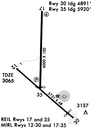
Runways
Runway Summary
| Runways: | 12/30 17/35 |
| Longest Runway: | 17/35 is 6000 ft (1829 m) long |
| Runways with an Instrument Approach: |
KULS Airport Runway Details
| Runway 12/30 | 4600 ft x 60 ft (1402 m x 18 m) | |
| Runway Length Source: | 3RD PARTY SURVEY as of 06/19/2020 | |
| Surface: | Concrete - Good condition - No special surface treatment | |
| Runway Pavement Class: | 7 /R/C/X/U | |
| Runway Edge Lights: | Medium Intensity | |
Runway Weight Bearing Capacity (in thousands of pounds) |
||
| Single Wheel Landing Gear: | 12.5 | |
Runway 12 |
Runway 30 |
|
Elevation: |
3071.0 | 3061.9 |
Latitude: |
37-36-10.3574N | 37-35-41.3335N |
Longitude: |
101-22-45.8912W | 101-22-01.8915W |
|
Runway True Alignment: |
130 | 310 |
Glide Path Angle: |
3.0 degrees | 3.0 degrees |
Traffic Pattern: |
Left | Left |
Runway Markings Type: |
Nonprecision Instrument | Nonprecision Instrument |
Runway Markings Condition: |
Good | Good |
Object at End: |
ROAD | |
Object Height: |
16 | |
Distance from End: |
700 | |
Object Centerline Offset: |
0 ft. left and right of centerline | |
Visual Glide Slope Indicators: |
2-Light PAPI On Left Side Of Runway | 2-Light PAPI On Left Side Of Runway |
Threshold Crossing Height: |
38 | 39 |
| Runway 17/35 | 6000 ft x 100 ft (1829 m x 30 m) | |
| Runway Length Source: | 3RD PARTY SURVEY as of 06/19/2020 | |
| Surface: | Concrete - Good condition - No special surface treatment | |
| Runway Pavement Class: | 19 /R/C/X/U | |
| Runway Edge Lights: | Medium Intensity | |
Runway Weight Bearing Capacity (in thousands of pounds) |
||
| Single Wheel Landing Gear: | 45.0 | |
| Dual Wheel Landing Gear: | 60.0 | |
Runway 17 |
Runway 35 |
|
Elevation: |
3065.3 | 3060.3 |
Latitude: |
37-36-58.3274N | 37-35-59.0178N |
Longitude: |
101-22-25.8239W | 101-22-25.2709W |
|
Runway True Alignment: |
180 | 360 |
Glide Path Angle: |
3.0 degrees | 3.0 degrees |
Traffic Pattern: |
Left | Left |
Runway Markings Type: |
Nonprecision Instrument | Nonprecision Instrument |
Runway Markings Condition: |
Good | Good |
Object at End: |
PLINE | |
Object Height: |
40 | |
Distance from End: |
1400 | |
Object Centerline Offset: |
0 ft. left and right of centerline | |
Visual Glide Slope Indicators: |
4-Light PAPI On Left Side Of Runway | 4-Light PAPI On Left Side Of Runway |
REIL: |
No | No |
Threshold Crossing Height: |
40 | 29 |
Services
Fuel Available: |
100LL |
Landing Fees: |
No |
Parking: |
Tiedowns available |
Maps & Diagrams
KULS Sectional
Flight Planning
at skyvector.com
at skyvector.com