Location
Latitude: |
39-00-57.7000N (39.016028) |
Longitude: |
087-38-59.2000W (-87.649778) |
Elevation: |
461.3 feet MSL (141 m MSL) |
Magnetic Variation: |
3.8 W (as of April 2024 from WMM2020 model) |
Time Zone: |
UTC -6.0 (Standard Time) UTC -5.0 (Daylight Savings Time) |
From City: |
04 N.M. E of Robinson, Illinois |
Found On: |
St Louis Chart |
FAA Region: |
AGL |
Contacts
Manager: |
Publicly owned: |
| HOWARD HUNT & SANDY STASZAK 10748 NORTH 1650 ST PALESTINE, IL 62451 618-586-2121 |
CRAWFORD COUNTY ARPT AUTHORITY 10748 NORTH 1650 ST PALESTINE, IL 62451 618-586-2121 |
Operations
Airport Status: |
Operational |
Facility Use: |
Public |
Type: |
Airport |
Activation Date: |
10/1951 |
Control tower: |
No |
Attendance (Months/Days/Hours): |
Months/Days/Hours ALL/MON-SAT/0700-1800 |
Boundary ARTCC: |
ZID (Indianapolis) |
Responsible ARTCC: |
ZID (Indianapolis) |
Lighting Schedule: |
SEE RMK |
Segmented Circle Indicator: |
Yes |
Traffic Pattern Altitude (MSL): |
1461 feet (445 m) |
NOTAMs Facility: |
RSV |
NOTAM-D Service: |
Yes |
International Airport of Entry: |
No |
Customs Landing Rights: |
No |
Military Landing Rights: |
Yes |
Civil/Military Joint Use: |
No |
Based Aircraft
| Single Engine: | 14 |
| Multi Engine: | 2 |
Annual Operations (as of 07/31/2021)
| Total Operations: | 11500 | |
| Air Taxi: | 800 | 7.0% |
| GA Local: | 5650 | 49.1% |
| GA Itinerant: | 5000 | 43.5% |
| Military Aircraft: | 50 | 0.4% |
Communications
| CTAF: | 123.000 |
| Unicom: | 123.000 |
| Approach: | HULMAN 119.25 119.25 |
| Departure: | HULMAN 119.25 119.25 |
| AWOS-3: | 120.50 (618-586-2772) |
Fixed Based Operators (FBOs) & Fuel
(Click on a business for detail)
Please help us keep this information up to date. This is a FREE SERVICE just like everything else on Airport Guide! If you see that a business needs to be added, modified, or deleted please fill out our Update Form.
To add, modify, or delete a business click here.
Please help us keep this information up to date. This is a FREE SERVICE just like everything else on Airport Guide! If you see that a business needs to be added, modified, or deleted please fill out our Update Form.
Area Code: 618 |
| Business Name | Frequency | Phone | Fuel Grade |
|---|---|---|---|
| Bonelli Aerodrome
Update FBO info |
Unicom 123.0 | 586-2538 | 100LL, Jet A |

|
 Independent |
100LL - 2.09 USD per gallon on 3/22/02 |
Pumps Requiring Line Service |
Flight Service Stations
| Primary | Alternate | |
| FSS on Field: | N | |
| FSS Name (ID): | Saint Louis(STL) | |
| Frequency: | ||
| Toll Free Phone: | 1-800-WX-BRIEF |
Instrument Procedures / Charts
FAA Terminal Procedures valid from 0901Z 03/21/24 to 0901Z 04/18/24.
There are various types of charts available for an airport. They are listed in the Page Type column. Here is a legend for those types:
APD - Airport Diagram
DP - Departure Procedure Charts
HOT - Hot Spots
IAP - Instrument Approach Procedure Charts
MIN - Minimums
STAR - Standard Terminal Arrival Charts
| Page Type | Page Name | Volume | Action Since Last Cycle |
|---|---|---|---|
| IAP | NDB RWY 17 | EC-3 | |
| IAP | RNAV (GPS) RWY 09 | EC-3 | |
| IAP | RNAV (GPS) RWY 17 | EC-3 | |
| IAP | RNAV (GPS) RWY 27 | EC-3 | |
| MIN | ALTERNATE MINIMUMS | EC-3 | |
| MIN | TAKEOFF MINIMUMS | EC-3 |
Terminal Procedures are only available for airports in several countries with more being added all the time. If you are looking for a specific country's charts, please send an email to support(at)airportguide.com stating the country name. This will be used to prioritize the implementation.
Navigation Aids (Navaids) near KRSV
| Dist (NM) | ID | Morse Code | Name | Type | Freq | True Hdg | Mag Hdg |
|---|---|---|---|---|---|---|---|
| 0.1 | RSV | . _ . . . . . . . _ | Robinson | VOR-DME | 108.40 | 23 | 27 |
| 0.4 | PLX | . _ _ . . _ . . _ . . _ | Palestine | NDB | 391 | 106 | 110 |
| 11.1 | SIV | . . . . . . . . _ | Sullivan | NDB | 326 | 58 | 62 |
| 14.9 | LWV | . _ . . . _ _ . . . _ | Lawrenceville | DME | 108.8 | 171 | 175 |
| 20.0 | OEA | _ _ _ . . _ | Vincennes | NDB | 251 | 167 | 171 |
| 23.9 | CZB | _ . _ . _ _ . . _ . . . | Casey | NDB | 359 | 316 | 320 |
| 25.2 | HU | . . . . . . _ | Yinno | NDB | 245 | 27 | 31 |
| 30.3 | OLY | _ _ _ . _ . . _ . _ _ | Olney | NDB | 272 | 233 | 237 |
| 33.9 | TTH | _ _ . . . . | Terre Haute | VORTAC | 115.30 | 33 | 37 |
| 35.3 | MT | _ _ _ | Zebre | NDB | 347 | 316 | 320 |
| 37.8 | SAM | . . . . _ _ _ | Samsville | DME | 116.6 | 212 | 216 |
| 39.2 | BIB | _ . . . . . _ . . . | Bible Grove | VORTAC | 109.00 | 261 | 265 |
| 40.5 | MTO | _ _ _ _ _ _ | Mattoon | DME | 109.4 | 313 | 317 |
| 48.9 | OOM | _ _ _ _ _ _ _ _ | Hoosier | VORTAC | 110.20 | 80 | 84 |
| 52.2 | FWC | . . _ . . _ _ _ . _ . | Wayne County | NDB | 257 | 223 | 227 |
| 56.3 | HNB | . . . . _ . _ . . . | Huntingburg | VOR-DME | 109.20 | 144 | 148 |
| 57.3 | TVX | _ . . . _ _ . . _ | Greencastle | NDB | 521 | 42 | 46 |
| 57.6 | BFR | _ . . . . . _ . . _ . | Bedford | NDB | 344 | 100 | 104 |
| 58.8 | PDW | . _ _ . _ . . . _ _ | Evansville | NDB | 284 | 174 | 178 |
| 60.2 | SYZ | . . . _ . _ _ _ _ . . | Shelbyville | NDB | 365 | 293 | 296 |
Nearby Airports with Fuel
Notices to Airmen (NOTAMS)
Remarks
| A110-1 | FOR CD CTC HULMAN APCH AT 812-877-7581. |
| A81-APT | MIRL RY 09/27 PRESET ON LOW INTST; TO INCR INTST & ACTVT MIRL RY 17/35 , REIL RYS 09, 27 & 17 PVASI RYS 09 & 27 - CTAF. |
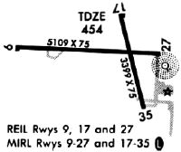
Runways
Runway Summary
| Runways: | 09/27 17/35 |
| Longest Runway: | 09/27 is 5108 ft (1557 m) long |
| Runways with an Instrument Approach: |
KRSV Airport Runway Details
| Runway 09/27 | 5108 ft x 100 ft (1557 m x 30 m) | |
| Runway Length Source: | 3RD PARTY SURVEY as of 06/25/2012 | |
| Surface: | Asphalt - Good condition - No special surface treatment | |
| Runway Edge Lights: | Medium Intensity | |
Runway Weight Bearing Capacity (in thousands of pounds) |
||
| Single Wheel Landing Gear: | 35.0 | |
| Dual Wheel Landing Gear: | 50.0 | |
| Dual Tandem Wheel Landing Gear: | 65.0 | |
Runway 09 |
Runway 27 |
|
Elevation: |
461.3 | 454.5 |
Latitude: |
39-00-59.9086N | 39-00-58.3126N |
Longitude: |
087-39-39.5725W | 087-38-34.8849W |
|
Runway True Alignment: |
092 | 272 |
Glide Path Angle: |
3.0 degrees | 3.0 degrees |
Traffic Pattern: |
Left | Left |
Runway Markings Type: |
Nonprecision Instrument | Nonprecision Instrument |
Runway Markings Condition: |
Good | Good |
Visual Glide Slope Indicators: |
Pulsating/Steady Burning VASI On Left Side Of Runway | Pulsating/Steady Burning VASI On Left Side Of Runway |
REIL: |
Yes | Yes |
Touchdown Lights: |
No | No |
Centerline Lights: |
No | No |
Threshold Crossing Height: |
27 | 25 |
| Runway 17/35 | 3398 ft x 75 ft (1036 m x 23 m) | |
| Runway Length Source: | 3RD PARTY SURVEY as of 06/25/2012 | |
| Surface: | Asphalt - Good condition - No special surface treatment | |
| Runway Edge Lights: | Medium Intensity | |
Runway Weight Bearing Capacity (in thousands of pounds) |
||
| Single Wheel Landing Gear: | 5.0 | |
Runway 17 |
Runway 35 |
|
Elevation: |
455.3 | 452.0 |
Latitude: |
39-01-11.8974N | 39-00-39.3330N |
Longitude: |
087-38-52.4755W | 087-38-41.9196W |
|
Runway True Alignment: |
166 | 346 |
Glide Path Angle: |
0.0 degrees | 0.0 degrees |
Traffic Pattern: |
Left | Left |
Runway Markings Type: |
Nonprecision Instrument | Nonprecision Instrument |
Runway Markings Condition: |
Good | Good |
REIL: |
Yes | No |
Touchdown Lights: |
No | No |
Centerline Lights: |
No | No |
Services
Airframe Repair: |
Minor |
Powerplant Repair: |
Minor |
Bottled Oxygen: |
None |
Bulk Oxygen: |
None |
Fuel Available: |
100LL |
Landing Fees: |
No |
Parking: |
Tiedowns available |
Maps & Diagrams
KRSV Sectional
Flight Planning
at skyvector.com
at skyvector.com