Location
Latitude: |
41-30-58.5740N (41.516271) |
Longitude: |
082-52-10.1520W (-82.869487) |
Elevation: |
590.1 feet MSL (180 m MSL) |
Magnetic Variation: |
7.6 W (as of April 2024 from WMM2020 model) |
Time Zone: |
UTC -5.0 (Standard Time) UTC -4.0 (Daylight Savings Time) |
From City: |
03 N.M. E of Port Clinton, Ohio |
Found On: |
Detroit Chart |
FAA Region: |
AGL |
Contacts
Manager: |
Publicly owned: |
| CLAYTON F FINKEN 3255 E STATE RD PORT CLINTON, OH 43452-2542 419-734-6297 |
ERIE OTTAWA ARPT AUTH 3255 E STATE RD PORT CLINTON, OH 43452-2542 419-734-6297 |
Operations
Airport Status: |
Operational |
Facility Use: |
Public |
Type: |
Airport |
Activation Date: |
07/1971 |
Control tower: |
No |
Attendance (Months/Days/Hours): |
Months/Days/Hours ALL/ALL/0700-1700 |
Boundary ARTCC: |
ZOB (Cleveland) |
Responsible ARTCC: |
ZOB (Cleveland) |
Lighting Schedule: |
SEE RMK |
Segmented Circle Indicator: |
No |
Traffic Pattern Altitude (MSL): |
1590 feet (485 m) |
NOTAMs Facility: |
CLE |
NOTAM-D Service: |
Yes |
International Airport of Entry: |
No |
Customs Landing Rights: |
Yes |
Military Landing Rights: |
Yes |
Civil/Military Joint Use: |
No |
Based Aircraft
| Single Engine: | 80 |
| Multi Engine: | 11 |
| Jet Engine: | 7 |
Annual Operations (as of 10/21/2020)
| Total Operations: | 54150 | |
| Air Taxi: | 14000 | 25.9% |
| GA Local: | 25000 | 46.2% |
| GA Itinerant: | 15000 | 27.7% |
| Military Aircraft: | 150 | 0.3% |
Communications
| CTAF: | 122.800 |
| Unicom: | 122.800 |
| Approach: | CLEVELAND 126.35 126.35 |
| Departure: | CLEVELAND 126.35 126.35 |
| AWOS-3: | 118.775 (419-734-9955) |
Fixed Based Operators (FBOs) & Fuel
(Click on a business for detail)
Please help us keep this information up to date. This is a FREE SERVICE just like everything else on Airport Guide! If you see that a business needs to be added, modified, or deleted please fill out our Update Form.
To add, modify, or delete a business click here.
Please help us keep this information up to date. This is a FREE SERVICE just like everything else on Airport Guide! If you see that a business needs to be added, modified, or deleted please fill out our Update Form.
Area Code: 419 |
| Business Name | Frequency | Phone | Fuel Grade |
|---|---|---|---|
| Griffing's Island Airlines
Update FBO info |
734-3149 |
Flight Service Stations
| Primary | Alternate | |
| FSS on Field: | N | |
| FSS Name (ID): | Cleveland(CLE) | |
| Frequency: | ||
| Toll Free Phone: | 1-800-WX-BRIEF |
Instrument Procedures / Charts
FAA Terminal Procedures valid from 0901Z 03/21/24 to 0901Z 04/18/24.
There are various types of charts available for an airport. They are listed in the Page Type column. Here is a legend for those types:
APD - Airport Diagram
DP - Departure Procedure Charts
HOT - Hot Spots
IAP - Instrument Approach Procedure Charts
MIN - Minimums
STAR - Standard Terminal Arrival Charts
| Page Type | Page Name | Volume | Action Since Last Cycle |
|---|---|---|---|
| IAP | NDB RWY 27 | EC-2 | |
| IAP | RNAV (GPS) RWY 09 | EC-2 | |
| IAP | RNAV (GPS) RWY 27 | EC-2 | |
| MIN | ALTERNATE MINIMUMS | EC-2 | |
| MIN | TAKEOFF MINIMUMS | EC-2 |
Terminal Procedures are only available for airports in several countries with more being added all the time. If you are looking for a specific country's charts, please send an email to support(at)airportguide.com stating the country name. This will be used to prioritize the implementation.
Navigation Aids (Navaids) near KPCW
| Dist (NM) | ID | Morse Code | Name | Type | Freq | True Hdg | Mag Hdg |
|---|---|---|---|---|---|---|---|
| 0.1 | PCW | . _ _ . _ . _ . . _ _ | Port Clinton | NDB | 423 | 11 | 19 |
| 10.8 | SKY | . . . _ . _ _ . _ _ | Sandusky | VOR-DME | 109.20 | 116 | 124 |
| 29.7 | TII | _ . . . . | Tiffin | NDB | 269 | 211 | 218 |
| 30.8 | FZI | . . _ . _ _ . . . . | Fostoria | NDB | 379 | 230 | 237 |
| 33.2 | DJB | _ . . . _ _ _ _ . . . | Dryer | VOR-DME | 113.60 | 106 | 114 |
| 34.8 | VWV | . . . _ . _ _ . . . _ | Waterville | VOR-DME | 113.10 | 263 | 270 |
| 37.3 | RYS | . _ . _ . _ _ . . . | Grosse Ile | NDB | 419 | 340 | 348 |
| 40.8 | MFD | _ _ . . _ . _ . . | Mansfield | VORTAC | 108.80 | 161 | 169 |
| 41.4 | CRL | _ . _ . . _ . . _ . . | Carleton | VOR-DME | 115.70 | 320 | 327 |
| 42.0 | TOL | _ _ _ _ . _ . . | Toledo | TACAN | 112.50 | 276 | 283 |
| 43.3 | AAU | . _ . _ . . _ | Ashland | NDB | 329 | 139 | 147 |
| 44.0 | YQG | _ . _ _ _ _ . _ _ _ . | Windsor | VOR-DME | 113.80 | 2 | 10 |
| 44.4 | ZQG | Laurel | NDB | 398 | 349 | 357 | |
| 44.8 | JZJ | . _ _ _ _ _ . . . _ _ _ | Alaina | NDB | 223 | 340 | 348 |
| 46.2 | CLE | _ . _ . . _ . . . | Cleveland | VOT | 110.40 | 96 | 104 |
| 46.7 | BNR | _ . . . _ . . _ . | Benton Ridge | NDB | 334 | 230 | 237 |
| 47.3 | TO | _ _ _ _ | Tophr | NDB | 219 | 273 | 280 |
| 47.3 | DXO | _ . . _ . . _ _ _ _ | Detroit | VOR-DME | 113.40 | 332 | 339 |
| 47.8 | QG | Windsor | NDB | 353 | 0 | 8 | |
| 48.2 | DTW | _ . . _ . _ _ | Detroit Met Wayne | VOT | 109.80 | 333 | 340 |
Nearby Airports with Fuel
Notices to Airmen (NOTAMS)
Remarks
| A110-2 | TXL A CLSD TO ACFT WITH WINGSPAN GTR THAN 49 FT. |
| A110-3 | BIRDS & OTR WILDLIFE ON & INVOF ARPT. |
| A110-4 | FOR CD CTC CLEVELAND APCH AT 216-352-2323. |
| A110-5 | CUST AVBL 24 HRS 7 DAYS PER WEEK. REQ MUST BE MADE PRIOR TO ARR. LCL OFC 419-732-4446. |
| A30-09/27 | CALM WIND RWY. |
| A75 | SUBJ AVBLTY, PPR AFT HRS. |
| A81-APT | ACTVT REIL RWY 09 & 27; HIRL RWY 09/27; MIRL RWY 18/36 - CTAF. PAPI RWY 09 & 27 OPR CONSLY. |
Runways
Runway Summary
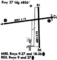
| Runways: | 09/27 18/36 |
| Longest Runway: | 09/27 is 5646 ft (1721 m) long |
| Runways with an Instrument Approach: |
KPCW Airport Runway Details
| Runway 09/27 | 5646 ft x 100 ft (1721 m x 30 m) | |
| Runway Length Source: | 3RD PARTY SURVEY as of 07/21/2021 | |
| Surface: | Asphalt - Good condition - Saw-cut or plastic grooved | |
| Runway Edge Lights: | High Intensity | |
Runway Weight Bearing Capacity (in thousands of pounds) |
||
| Single Wheel Landing Gear: | 100.0 | |
Runway 09 |
Runway 27 |
|
Elevation: |
588.7 | 588.2 |
Latitude: |
41-30-57.7025N | 41-31-04.8789N |
Longitude: |
082-52-54.0084W | 082-51-40.4090W |
|
Runway True Alignment: |
083 | 263 |
Glide Path Angle: |
3.0 degrees | 3.0 degrees |
Traffic Pattern: |
Left | Left |
Runway Markings Type: |
Nonprecision Instrument | Nonprecision Instrument |
Runway Markings Condition: |
Good | Good |
Object at End: |
TREE | TREE |
Object Height: |
65 | 42 |
Distance from End: |
1659 | 1098 |
Object Centerline Offset: |
402 ft. right of centerline | 334 ft. right of centerline |
Visual Glide Slope Indicators: |
4-Light PAPI On Left Side Of Runway | 4-Light PAPI On Left Side Of Runway |
REIL: |
Yes | Yes |
Touchdown Lights: |
No | No |
Centerline Lights: |
No | No |
Threshold Crossing Height: |
40 | 40 |
Threshold Elevation: |
588.2 | |
Displaced Threshold: |
201 | |
Threshold Latitude: |
41-31-04.6260N | |
Threshold Longitude: |
082-51-43.0284W |
| Runway 18/36 | 4002 ft x 75 ft (1220 m x 23 m) | |
| Runway Length Source: | 3RD PARTY SURVEY as of 07/21/2021 | |
| Surface: | Asphalt - Good condition - No special surface treatment | |
| Runway Edge Lights: | Medium Intensity | |
Runway 18 |
Runway 36 |
|
Elevation: |
586.1 | 589.0 |
Latitude: |
41-31-14.4953N | 41-30-34.9820N |
Longitude: |
082-52-01.1791W | 082-51-59.2138W |
|
Runway True Alignment: |
178 | 358 |
Glide Path Angle: |
0.0 degrees | 0.0 degrees |
Traffic Pattern: |
Left | Left |
Runway Markings Type: |
Basic | Basic |
Runway Markings Condition: |
Fair | Fair |
Object Centerline Offset: |
402 ft. right of centerline | 334 ft. right of centerline |
REIL: |
No | No |
Touchdown Lights: |
No | No |
Centerline Lights: |
No | No |
Services
Airframe Repair: |
None |
Powerplant Repair: |
None |
Bottled Oxygen: |
None |
Bulk Oxygen: |
None |
Fuel Available: |
100LL |
Landing Fees: |
No |
Parking: |
Tiedowns available |
Maps & Diagrams
KPCW Sectional
Flight Planning
at skyvector.com
at skyvector.com