Location
Latitude: |
39-02-43.2000N (39.045333) |
Longitude: |
085-36-20.2000W (-85.605611) |
Elevation: |
757.2 feet MSL (231 m MSL) |
Magnetic Variation: |
5.3 W (as of April 2024 from WMM2020 model) |
Time Zone: |
UTC -5.0 (Standard Time) UTC -4.0 (Daylight Savings Time) |
From City: |
02 N.M. NE of North Vernon, Indiana |
Found On: |
St Louis Chart |
FAA Region: |
AGL |
Contacts
Manager: |
Publicly owned: |
| RYAN A. CURRY 645 E CO RD 450N NORTH VERNON, IN 47265 812-346-5223 |
NORTH VERNON BOAC 645 E CO RD 450N NORTH VERNON, IN 47265 812-346-5223 |
Operations
Airport Status: |
Operational |
Facility Use: |
Public |
Type: |
Airport |
Activation Date: |
02/1944 |
Control tower: |
No |
Attendance (Months/Days/Hours): |
Months/Days/Hours ALL/MON-SAT/0800-1700 |
Boundary ARTCC: |
ZID (Indianapolis) |
Responsible ARTCC: |
ZID (Indianapolis) |
Lighting Schedule: |
SEE RMK |
Segmented Circle Indicator: |
No |
Traffic Pattern Altitude (MSL): |
1757 feet (536 m) |
NOTAMs Facility: |
HUF |
NOTAM-D Service: |
Yes |
International Airport of Entry: |
No |
Customs Landing Rights: |
No |
Military Landing Rights: |
Yes |
Civil/Military Joint Use: |
No |
Based Aircraft
| Single Engine: | 32 |
| Multi Engine: | 3 |
| Jet Engine: | 1 |
Annual Operations (as of 12/31/2019)
| Total Operations: | 8572 | |
| Air Taxi: | 258 | 3.0% |
| GA Local: | 4371 | 51.0% |
| GA Itinerant: | 1886 | 22.0% |
| Military Aircraft: | 2057 | 24.0% |
Communications
| CTAF: | 122.700 |
| Unicom: | 122.700 |
| AWOS-3: | 120.625 (812-346-5041) |
- APCH/DEP SVC PRVDD BY INDIANAPOLIS ARTCC ON FREQS 124.775/269.025 (HENRYVILLE RCAG).
- COMMUNICATIONS PRVDD BY TERRE HAUTE RADIO ON FREQ 122.3 (OSGOOD RCO).
Fixed Based Operators (FBOs) & Fuel
(Click on a business for detail)
Please help us keep this information up to date. This is a FREE SERVICE just like everything else on Airport Guide! If you see that a business needs to be added, modified, or deleted please fill out our Update Form.
To add, modify, or delete a business click here.
Please help us keep this information up to date. This is a FREE SERVICE just like everything else on Airport Guide! If you see that a business needs to be added, modified, or deleted please fill out our Update Form.
Area Code: 812 |
| Business Name | Frequency | Phone | Fuel Grade |
|---|---|---|---|
| Jones Flying Service
Update FBO info |
Unicom 122.7 | 522-8623 | |
| St. Anne Service
Update FBO info |
Unicom 122.7 | 346-5223 | 100LL, Jet A |
Flight Service Stations
| Primary | Alternate | |
| FSS on Field: | N | |
| FSS Name (ID): | Terre Haute(HUF) | |
| Frequency: | ||
| Toll Free Phone: | 1-800-WX-BRIEF |
Instrument Procedures / Charts
FAA Terminal Procedures valid from 0901Z 03/21/24 to 0901Z 04/18/24.
There are various types of charts available for an airport. They are listed in the Page Type column. Here is a legend for those types:
APD - Airport Diagram
DP - Departure Procedure Charts
HOT - Hot Spots
IAP - Instrument Approach Procedure Charts
MIN - Minimums
STAR - Standard Terminal Arrival Charts
| Page Type | Page Name | Volume | Action Since Last Cycle |
|---|---|---|---|
| IAP | RNAV (GPS) RWY 05 | EC-2 | |
| IAP | RNAV (GPS) Y RWY 23 | EC-2 | |
| IAP | RNAV (GPS) Z RWY 23 | EC-2 | |
| MIN | TAKEOFF MINIMUMS | EC-2 |
Terminal Procedures are only available for airports in several countries with more being added all the time. If you are looking for a specific country's charts, please send an email to support(at)airportguide.com stating the country name. This will be used to prioritize the implementation.
Navigation Aids (Navaids) near KOVO
| Dist (NM) | ID | Morse Code | Name | Type | Freq | True Hdg | Mag Hdg |
|---|---|---|---|---|---|---|---|
| 18.3 | GVR | _ _ . . . . _ . _ . | Hanover | DME | 114.65 | 159 | 164 |
| 19.3 | BA | _ . . . . _ | Clifs | NDB | 410 | 329 | 334 |
| 20.2 | EQZ | . _ _ . _ _ _ . . | Captain | NDB | 308 | 238 | 243 |
| 24.2 | HLB | . . . . . _ . . _ . . . | Batesville | NDB | 254 | 41 | 46 |
| 27.4 | ABB | . _ _ . . . _ . . . | Nabb | VORTAC | 112.40 | 182 | 187 |
| 34.8 | JV | . _ _ _ . . . _ | Catch | NDB | 331 | 190 | 195 |
| 36.7 | SHB | . . . . . . . _ . . . | Shelbyville | VOR-DME | 116.15 | 343 | 348 |
| 38.8 | UR | . . _ . _ . | Burln | NDB | 321 | 89 | 95 |
| 40.7 | BFR | _ . . . . . _ . . _ . | Bedford | NDB | 344 | 252 | 257 |
| 41.8 | HFY | . . . . . . _ . _ . _ _ | Greenwood | NDB | 398 | 327 | 332 |
| 42.1 | CVG | _ . _ . . . . _ _ _ . | Cincinnati | VORTAC | 117.30 | 92 | 98 |
| 47.3 | OOM | _ _ _ _ _ _ _ _ | Hoosier | VORTAC | 110.20 | 277 | 282 |
| 47.3 | OXD | _ _ _ _ . . _ _ . . | Oxford | NDB | 282 | 53 | 59 |
| 49.0 | BQM | _ . . . _ _ . _ _ _ | Bowman | DME | 112.2 | 183 | 188 |
| 49.1 | SQ | . . . _ _ . _ | Pnthr | NDB | 227 | 26 | 32 |
| 51.8 | UWL | . . _ . _ _ . _ . . | New Castle | NDB | 385 | 14 | 19 |
| 51.8 | SDF | . . . _ . . . . _ . | Louisville Standifd | VOT | 111.00 | 186 | 191 |
| 51.9 | HAO | . . . . . _ _ _ _ | Hamilton | NDB | 260 | 67 | 73 |
| 52.5 | IND | . . _ . _ . . | Indianapolis Intl | VOT | 109.60 | 321 | 326 |
| 54.0 | LK | . _ . . _ . _ | Laang | NDB | 414 | 181 | 186 |
Nearby Airports with Fuel
Notices to Airmen (NOTAMS)
Remarks
| A110-1 | 24 HR SELF SERVICE FUEL AVBL. |
| A110-2 | FOR CD IF UNA TO CTC ON FSS FREQ, CTC INDIANAPOLIS ARTCC AT 317-247-2411. |
| A58-05 | 10 FT CROPS 125 FT R OF RWY END CNTRLN. |
| A58-15 | 10 FT CROPS 60 FT L OF RWY END CNTRLN. |
| A58-23 | 10 FT CROPS 80 FT L OF RWY END CNTRLN. |
| A58-33 | 10 FT CROPS 60 FT L & R OF RWY END CNTRLN. |
| A81-APT | ACTVT PAPI RWY 05 & 23: MIRL RWY 05/23 - CTAF. |
Runways
Runway Summary
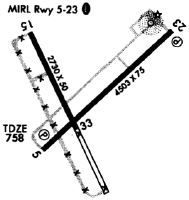
| Runways: | 05/23 15/33 |
| Longest Runway: | 05/23 is 5002 ft (1525 m) long |
| Runways with an Instrument Approach: |
KOVO Airport Runway Details
| Runway 05/23 | 5002 ft x 75 ft (1525 m x 23 m) | |
| Runway Length Source: | 3RD PARTY SURVEY as of 03/20/2007 | |
| Surface: | Asphalt - Excellent condition - No special surface treatment | |
| Runway Edge Lights: | Medium Intensity | |
Runway Weight Bearing Capacity (in thousands of pounds) |
||
| Single Wheel Landing Gear: | 100.0 | |
| Dual Wheel Landing Gear: | 135.0 | |
| Dual Tandem Wheel Landing Gear: | 230.0 | |
Runway 05 |
Runway 23 |
|
Elevation: |
757.2 | 754.8 |
Latitude: |
39-02-25.0367N | 39-02-58.3005N |
Longitude: |
085-36-37.8379W | 085-35-50.9098W |
|
Runway True Alignment: |
048 | 228 |
Glide Path Angle: |
3.0 degrees | 3.0 degrees |
Traffic Pattern: |
Left | Left |
Runway Markings Type: |
Nonprecision Instrument | Nonprecision Instrument |
Runway Markings Condition: |
Good | Good |
Object at End: |
ROAD | ROAD |
Visual Glide Slope Indicators: |
2-Light PAPI On Left Side Of Runway | 2-Light PAPI On Left Side Of Runway |
Threshold Crossing Height: |
34 | 27 |
| Runway 15/33 | 2730 ft x 50 ft (832 m x 15 m) | |
| Runway Length Source: | 3RD PARTY SURVEY as of 03/15/2007 | |
| Surface: | Asphalt - Excellent condition - No special surface treatment | |
| Runway Edge Lights: | Medium Intensity | |
Runway Weight Bearing Capacity (in thousands of pounds) |
||
| Single Wheel Landing Gear: | 4.0 | |
Runway 15 |
Runway 33 |
|
Elevation: |
751.9 | 756.4 |
Latitude: |
39-02-57.9088N | 39-02-33.9116N |
Longitude: |
085-36-38.8546W | 085-36-23.0510W |
|
Runway True Alignment: |
153 | 333 |
Glide Path Angle: |
0.0 degrees | 3.5 degrees |
Traffic Pattern: |
Left | Left |
Runway Markings Type: |
Basic | Basic |
Runway Markings Condition: |
Good | Fair |
Object at End: |
ROAD | TREES |
Object Height: |
14 | 55 |
Distance from End: |
375 | 1120 |
Visual Glide Slope Indicators: |
2-Light PAPI On Left Side Of Runway | |
Threshold Crossing Height: |
27 |
Services
Airframe Repair: |
Minor |
Powerplant Repair: |
Minor |
Fuel Available: |
100LL, Jet A |
Landing Fees: |
No |
Parking: |
Hangars and tiedowns available |
Maps & Diagrams
KOVO Sectional
Flight Planning
at skyvector.com
at skyvector.com