Location
Latitude: |
35-59-52.7000N (35.997972) |
Longitude: |
089-24-23.7000W (-89.406583) |
Elevation: |
337.7 feet MSL (103 m MSL) |
Magnetic Variation: |
2.3 W (as of April 2024 from WMM2020 model) |
Time Zone: |
UTC -6.0 (Standard Time) UTC -5.0 (Daylight Savings Time) |
From City: |
02 N.M. S of Dyersburg, Tennessee |
Found On: |
St Louis Chart |
FAA Region: |
ASO |
Contacts
Manager: |
Publicly owned: |
| DIAN DAWSON 315 AIRPORT ROAD DYERSBURG, TN 38024 731-445-3979 |
CITY OF DYERSBURG CITY HALL, PO BOX 1358 DYERSBURG, TN 38024 (731) 288-7600 |
Operations
Airport Status: |
Operational |
Facility Use: |
Public |
Type: |
Airport |
Activation Date: |
07/1944 |
Control tower: |
No |
Attendance (Months/Days/Hours): |
Months/Days/Hours NOV-MAR/ALL/0800-1700 |
Boundary ARTCC: |
ZME (Memphis) |
Responsible ARTCC: |
ZME (Memphis) |
Lighting Schedule: |
SEE RMK |
Segmented Circle Indicator: |
Yes |
Traffic Pattern Altitude (MSL): |
1338 feet (408 m) |
NOTAMs Facility: |
DYR |
NOTAM-D Service: |
Yes |
International Airport of Entry: |
No |
Customs Landing Rights: |
No |
Military Landing Rights: |
Yes |
Civil/Military Joint Use: |
No |
Based Aircraft
| Single Engine: | 21 |
| Multi Engine: | 3 |
| Jet Engine: | 1 |
Annual Operations (as of 05/08/2019)
| Total Operations: | 7800 | |
| Air Taxi: | 80 | 1.0% |
| GA Local: | 2600 | 33.3% |
| GA Itinerant: | 5000 | 64.1% |
| Military Aircraft: | 120 | 1.5% |
Communications
| CTAF: | 123.050 |
| Unicom: | 123.050 |
| AWOS-3PT: | 135.625 (731-287-0300) |
- APCH/DEP SVC PRVDD BY MEMPHIS ARTCC ON FREQS 134.65/316.15 (MCKELLAR RCAG).
Fixed Based Operators (FBOs) & Fuel
(Click on a business for detail)
Please help us keep this information up to date. This is a FREE SERVICE just like everything else on Airport Guide! If you see that a business needs to be added, modified, or deleted please fill out our Update Form.
To add, modify, or delete a business click here.
Please help us keep this information up to date. This is a FREE SERVICE just like everything else on Airport Guide! If you see that a business needs to be added, modified, or deleted please fill out our Update Form.
Area Code: 731 |
| Business Name | Frequency | Phone | Fuel Grade |
|---|---|---|---|
| Dyersburg Aviation & Avionics, Inc.
Update FBO info |
Unicom 123.05 | 286-2233 | 100LL, Jet A |
| Dyersburg Municipal Airport
Update FBO info |
Unicom 123.05 | 286-2233 | 100LL, Jet A |
Flight Service Stations
| Primary | Alternate | |
| FSS on Field: | N | |
| FSS Name (ID): | Jackson(MKL) | |
| Frequency: | ||
| Toll Free Phone: | 1-800-WX-BRIEF |
Instrument Procedures / Charts
FAA Terminal Procedures valid from 0901Z 03/21/24 to 0901Z 04/18/24.
There are various types of charts available for an airport. They are listed in the Page Type column. Here is a legend for those types:
APD - Airport Diagram
DP - Departure Procedure Charts
HOT - Hot Spots
IAP - Instrument Approach Procedure Charts
MIN - Minimums
STAR - Standard Terminal Arrival Charts
| Page Type | Page Name | Volume | Action Since Last Cycle |
|---|---|---|---|
| IAP | RNAV (GPS) RWY 04 | SE-1 | |
| IAP | RNAV (GPS) RWY 22 | SE-1 | |
| MIN | ALTERNATE MINIMUMS | SE-1 | |
| MIN | TAKEOFF MINIMUMS | SE-1 |
Terminal Procedures are only available for airports in several countries with more being added all the time. If you are looking for a specific country's charts, please send an email to support(at)airportguide.com stating the country name. This will be used to prioritize the implementation.
Navigation Aids (Navaids) near KDYR
| Dist (NM) | ID | Morse Code | Name | Type | Freq | True Hdg | Mag Hdg |
|---|---|---|---|---|---|---|---|
| 4.5 | DYR | _ . . _ . _ _ . _ . | Dyersburg | TACAN | 116.80 | 74 | 76 |
| 26.0 | COO | _ . _ . _ _ _ _ _ _ | Covington | NDB | 326 | 199 | 201 |
| 26.1 | GOJ | _ _ . _ _ _ . _ _ _ | Gosnell | VOR | 111.80 | 263 | 265 |
| 26.9 | UC | . . _ _ . _ . | Obion | NDB | 212 | 47 | 49 |
| 33.8 | MKL | _ _ _ . _ . _ . . | Mc Kellar | VOR-DME | 112.00 | 134 | 136 |
| 36.3 | MKL | _ _ _ . _ . _ . . | Mersy | NDB | 394 | 142 | 144 |
| 41.4 | MAW | _ _ . _ . _ _ | Malden | TACAN | 111.20 | 324 | 326 |
| 45.9 | HZD | . . . . _ _ . . _ . . | Huntingdon | NDB | 217 | 82 | 85 |
| 47.5 | FYE | . . _ . _ . _ _ . | Somerville | NDB | 255 | 179 | 181 |
| 50.1 | MIG | _ _ . . _ _ . | Millington | NDB | 232 | 210 | 212 |
| 50.4 | TIQ | _ . . _ _ . _ | Trainer | NDB | 410 | 72 | 75 |
| 50.9 | CHQ | _ . _ . . . . . _ _ . _ | Charleston | NDB | 208 | 2 | 4 |
| 56.3 | JKS | . _ _ _ _ . _ . . . | Jacks Creek | VOR-DME | 109.40 | 114 | 117 |
| 57.2 | SPQ | . . . . _ _ . _ _ . _ | Spain | NDB | 414 | 213 | 215 |
| 57.9 | JBR | . _ _ _ _ . . . . _ . | Jonesboro | VOR-DME | 115.85 | 263 | 265 |
| 60.1 | FD | . . _ . _ . . | Earli | NDB | 278 | 312 | 314 |
| 63.0 | SZY | . . . _ _ . . _ . _ _ | Sibley | NDB | 386 | 136 | 139 |
| 63.4 | MEM | _ _ . _ _ | Memphis Metropolitn | VOT | 111.00 | 206 | 208 |
| 64.4 | CIR | _ . _ . . . . _ . | Cairo | NDB | 397 | 7 | 9 |
| 64.9 | ME | _ _ . | Elvis | NDB | 287 | 210 | 212 |
Nearby Airports with Fuel
Notices to Airmen (NOTAMS)
Remarks
| A110-1 | FOR CD CTC MEMPHIS ARTCC AT 901-368-8453/8449. |
| A30-16/34 | CLSD INDEFLY. |
| A81-APT | ACTVT REIL RWY 04 & 22; MIRL RWY 04/22 - CTAF. PAPI RWY 04 & 22 ON CONSLY. |
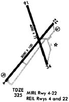
Runways
Runway Summary
| Runways: | 04/22 16/34 |
| Longest Runway: | 04/22 is 5698 ft (1737 m) long |
| Runways with an Instrument Approach: |
KDYR Airport Runway Details
| Runway 04/22 | 5698 ft x 98 ft (1737 m x 30 m) | |
| Runway Length Source: | 3RD PARTY SURVEY as of 07/28/2008 | |
| Surface: | Asphalt - Good condition - No special surface treatment | |
| Runway Pavement Class: | 9 /F/D/X/T | |
| Runway Edge Lights: | Medium Intensity | |
Runway Weight Bearing Capacity (in thousands of pounds) |
||
| Single Wheel Landing Gear: | 55.0 | |
| Dual Wheel Landing Gear: | 80.0 | |
| Dual Tandem Wheel Landing Gear: | 140.0 | |
Runway 04 |
Runway 22 |
|
Elevation: |
291.5 | 334.6 |
Latitude: |
35-59-25.5810N | 36-00-08.4045N |
Longitude: |
089-24-50.0162W | 089-24-04.9570W |
|
Runway True Alignment: |
040 | 221 |
Glide Path Angle: |
3.0 degrees | 3.0 degrees |
Traffic Pattern: |
Left | Left |
Runway Markings Type: |
Nonprecision Instrument | Nonprecision Instrument |
Runway Markings Condition: |
Good | Good |
Object at End: |
TREES | TREES |
Object Height: |
57 | 47 |
Distance from End: |
1478 | 780 |
Object Centerline Offset: |
371 ft. left of centerline | 371 ft. right of centerline |
Visual Glide Slope Indicators: |
4-Light PAPI On Left Side Of Runway | 4-Light PAPI On Left Side Of Runway |
REIL: |
Yes | Yes |
Threshold Crossing Height: |
35 | 28 |
Threshold Elevation: |
333.9 | |
Displaced Threshold: |
694 | |
Threshold Latitude: |
36-00-03.1915N | |
Threshold Longitude: |
089-24-10.4483W |
| Runway 16/34 | 4001 ft x 74 ft (1220 m x 23 m) | |
| Runway Length Source: | 3RD PARTY SURVEY as of 07/28/2008 | |
| Surface: | Asphalt - Good condition - No special surface treatment | |
Runway Weight Bearing Capacity (in thousands of pounds) |
||
| Single Wheel Landing Gear: | 50.0 | |
| Dual Wheel Landing Gear: | 75.0 | |
| Dual Tandem Wheel Landing Gear: | 135.0 | |
Runway 16 |
Runway 34 |
|
Elevation: |
337.7 | 325.3 |
Latitude: |
36-00-19.6462N | 35-59-42.1193N |
Longitude: |
089-24-26.0722W | 089-24-10.6590W |
|
Runway True Alignment: |
162 | 342 |
Glide Path Angle: |
0.0 degrees | 0.0 degrees |
Traffic Pattern: |
Left | Left |
Runway Markings Type: |
Basic | Basic |
Runway Markings Condition: |
Fair | Fair |
Object at End: |
TREE | TREE |
Object Height: |
27 | 78 |
Distance from End: |
947 | 816 |
Object Centerline Offset: |
371 ft. left of centerline | 371 ft. right of centerline |
Services
Airframe Repair: |
Minor |
Powerplant Repair: |
Major |
Bottled Oxygen: |
Low Pressure |
Fuel Available: |
100LL, Jet A+ |
Landing Fees: |
No |
Parking: |
Hangars and tiedowns available |
Maps & Diagrams
KDYR Sectional
Flight Planning
at skyvector.com
at skyvector.com