Location
Latitude: |
40-34-08.7000N (40.569083) |
Longitude: |
090-04-29.4000W (-90.074833) |
Elevation: |
683.9 feet MSL (208 m MSL) |
Magnetic Variation: |
2.2 W (as of April 2024 from WMM2020 model) |
Time Zone: |
UTC -6.0 (Standard Time) UTC -5.0 (Daylight Savings Time) |
From City: |
02 N.M. NW of Canton, Illinois |
Found On: |
Chicago Chart |
FAA Region: |
AGL |
Contacts
Manager: |
Publicly owned: |
| JON JOHNSON 250 S AVE D CANTON, IL 61520 309-647-1345 |
CANTON PARK DISTRICT 250 S AVE D CANTON, IL 61520 309-647-1345 |
Operations
Airport Status: |
Operational |
Facility Use: |
Public |
Type: |
Airport |
Control tower: |
No |
Attendance (Months/Days/Hours): |
Months/Days/Hours ALL/ALL/0700-DUSK |
Boundary ARTCC: |
ZAU (Chicago) |
Responsible ARTCC: |
ZKC (Kansas City) |
Lighting Schedule: |
SEE RMK |
Segmented Circle Indicator: |
Yes |
Traffic Pattern Altitude (MSL): |
1684 feet (513 m) |
NOTAMs Facility: |
IKK |
NOTAM-D Service: |
Yes |
International Airport of Entry: |
No |
Customs Landing Rights: |
No |
Military Landing Rights: |
Yes |
Civil/Military Joint Use: |
No |
Based Aircraft
| Single Engine: | 21 |
| Multi Engine: | 1 |
Annual Operations (as of 05/31/2021)
| Total Operations: | 19000 | |
| GA Local: | 17000 | 89.5% |
| GA Itinerant: | 2000 | 10.5% |
Communications
| CTAF: | 122.800 |
| Unicom: | 122.800 |
| Approach: | SAINT LOUIS 125.8 125.8 |
| Departure: | SAINT LOUIS 125.8 125.8 |
Fixed Based Operators (FBOs) & Fuel
(Click on a business for detail)
Please help us keep this information up to date. This is a FREE SERVICE just like everything else on Airport Guide! If you see that a business needs to be added, modified, or deleted please fill out our Update Form.
To add, modify, or delete a business click here.
Please help us keep this information up to date. This is a FREE SERVICE just like everything else on Airport Guide! If you see that a business needs to be added, modified, or deleted please fill out our Update Form.
Area Code: 309 |
| Business Name | Frequency | Phone | Fuel Grade |
|---|---|---|---|
| Temor Aviation, Inc.
Update FBO info |
800-647-6976, 647-6976 | 100LL, Mogas |
Flight Service Stations
| Primary | Alternate | |
| FSS on Field: | N | |
| FSS Name (ID): | Kankakee(IKK) | |
| Frequency: | ||
| Toll Free Phone: | 1-800-WX-BRIEF |
Instrument Procedures / Charts
FAA Terminal Procedures valid from 0901Z 03/21/24 to 0901Z 04/18/24.
There are various types of charts available for an airport. They are listed in the Page Type column. Here is a legend for those types:
APD - Airport Diagram
DP - Departure Procedure Charts
HOT - Hot Spots
IAP - Instrument Approach Procedure Charts
MIN - Minimums
STAR - Standard Terminal Arrival Charts
| Page Type | Page Name | Volume | Action Since Last Cycle |
|---|---|---|---|
| IAP | RNAV (GPS) RWY 18 | EC-3 | |
| IAP | RNAV (GPS) RWY 36 | EC-3 | |
| IAP | VOR-A | EC-3 | |
| MIN | TAKEOFF MINIMUMS | EC-3 |
Terminal Procedures are only available for airports in several countries with more being added all the time. If you are looking for a specific country's charts, please send an email to support(at)airportguide.com stating the country name. This will be used to prioritize the implementation.
Navigation Aids (Navaids) near KCTK
| Dist (NM) | ID | Morse Code | Name | Type | Freq | True Hdg | Mag Hdg |
|---|---|---|---|---|---|---|---|
| 0.2 | CTK | _ . _ . _ _ . _ | Canton | NDB | 236 | 206 | 208 |
| 14.5 | PIA | . _ _ . . . . _ | Peoria | VORTAC | 115.20 | 62 | 64 |
| 22.1 | PI | . _ _ . . . | Tungg | NDB | 356 | 84 | 86 |
| 22.3 | JZY | . _ _ _ _ _ . . _ . _ _ | Macomb | NDB | 251 | 262 | 264 |
| 27.5 | GBG | _ _ . _ . . . _ _ . | Galesburg | DME | 109.8 | 323 | 325 |
| 39.8 | BRL | _ . . . . _ . . _ . . | Burlington | VOR-DME | 111.40 | 283 | 285 |
| 41.7 | AAA | . _ . _ . _ | Abraham | NDB | 329 | 125 | 127 |
| 41.8 | BDF | _ . . . _ . . . . _ . | Bradford | VORTAC | 114.70 | 31 | 33 |
| 45.0 | LQ | . _ . . _ _ . _ | Licol | NDB | 375 | 151 | 153 |
| 47.4 | SPI | . . . . _ _ . . . | Spinner | VORTAC | 112.70 | 157 | 159 |
| 48.0 | BR | _ . . . . _ . | Burns | NDB | 390 | 276 | 278 |
| 48.1 | IJX | . . . _ _ _ _ . . _ | Jacksonville | DME | 108.6 | 189 | 191 |
| 49.9 | SP | . . . . _ _ . | Huskk | NDB | 382 | 163 | 165 |
| 51.5 | CJ | _ . _ . . _ _ _ | Calde | NDB | 240 | 154 | 156 |
| 51.8 | MZV | _ _ _ _ . . . . . _ | Moline | VOR-DME | 114.40 | 330 | 332 |
| 52.4 | BMI | _ . . . _ _ . . | Bloomington | DME | 108.2 | 95 | 98 |
| 54.7 | LH | . _ . . . . . . | Egrow | NDB | 334 | 90 | 93 |
| 62.3 | EOK | . _ _ _ _ . _ | Keokuk | NDB | 366 | 264 | 266 |
| 62.9 | PNT | . _ _ . _ . _ | Pontiac | VOR-DME | 109.60 | 75 | 78 |
| 66.7 | DVN | _ . . . . . _ _ . | Davenport Municipal | VOT | 111.80 | 339 | 341 |
Nearby Airports with Fuel
Notices to Airmen (NOTAMS)
Remarks
| A110-1 | AWOS (DIGIWX) ACTVT 8 MIC CLICKS ON CTAF. |
| A110-2 | FOR CD CTC ST LOUIS APCH AT 314-890-1017. |
| A15 | EMAIL ADDRESS: CPD_JOHNSON@SBCGLOBAL.NET (ALL LOWER CASE) |
| A70-FUEL-10 | 0LL SELF-SERV FUELING |
| A81-APT | ACTVT MIRL RYS 09/27 & 18/36 & REIL RY 36 & TWY LGTS - 7 CLICKS ON CTAF. |
Runways
Runway Summary
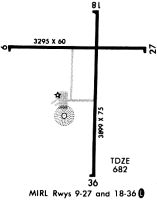
| Runways: | 09/27 18/36 |
| Longest Runway: | 18/36 is 3899 ft (1188 m) long |
| Runways with an Instrument Approach: |
KCTK Airport Runway Details
| Runway 09/27 | 3294 ft x 60 ft (1004 m x 18 m) | |
| Runway Length Source: | 3RD PARTY SURVEY as of 01/21/2011 | |
| Surface: | Asphalt - Good condition - No special surface treatment | |
| Runway Edge Lights: | Medium Intensity | |
Runway Weight Bearing Capacity (in thousands of pounds) |
||
| Single Wheel Landing Gear: | 11.0 | |
Runway 09 |
Runway 27 |
|
Elevation: |
683.8 | 681.8 |
Latitude: |
40-34-14.3395N | 40-34-14.5738N |
Longitude: |
090-04-54.2628W | 090-04-11.5747W |
|
Runway True Alignment: |
089 | 269 |
Glide Path Angle: |
0.0 degrees | 0.0 degrees |
Traffic Pattern: |
Left | Left |
Runway Markings Type: |
Basic | Basic |
Runway Markings Condition: |
Fair | Fair |
Object at End: |
TREES | |
Object Height: |
30 | |
Distance from End: |
630 | |
Object Centerline Offset: |
110 ft. left of centerline | |
REIL: |
No | No |
Touchdown Lights: |
No | No |
| Runway 18/36 | 3899 ft x 75 ft (1188 m x 23 m) | |
| Runway Length Source: | 3RD PARTY SURVEY as of 01/21/2011 | |
| Surface: | Asphalt - Good condition - No special surface treatment | |
| Runway Edge Lights: | Medium Intensity | |
Runway Weight Bearing Capacity (in thousands of pounds) |
||
| Single Wheel Landing Gear: | 10.0 | |
Runway 18 |
Runway 36 |
|
Elevation: |
681.9 | 670.3 |
Latitude: |
40-34-23.0689N | 40-33-44.5547N |
Longitude: |
090-04-25.9382W | 090-04-26.9816W |
|
Runway True Alignment: |
181 | 001 |
Glide Path Angle: |
0.0 degrees | 0.0 degrees |
Traffic Pattern: |
Left | Left |
Runway Markings Type: |
Nonprecision Instrument | Nonprecision Instrument |
Runway Markings Condition: |
Fair | Fair |
Object Centerline Offset: |
110 ft. left of centerline | |
REIL: |
No | Yes |
Touchdown Lights: |
No | No |
Centerline Lights: |
No | No |
Services
Airframe Repair: |
Major |
Powerplant Repair: |
Major |
Bottled Oxygen: |
High Pressure |
Bulk Oxygen: |
High Pressure |
Fuel Available: |
100LL, Jet A+ |
Parking: |
Hangars and tiedowns available |
Maps & Diagrams
KCTK Sectional
Flight Planning
at skyvector.com
at skyvector.com