Location
Latitude: |
35-10-39.1210N (35.177534) |
Longitude: |
086-03-58.1990W (-86.066166) |
Elevation: |
978.8 feet MSL (298 m MSL) |
Magnetic Variation: |
4.5 W (as of April 2024 from WMM2020 model) |
Time Zone: |
UTC -6.0 (Standard Time) UTC -5.0 (Daylight Savings Time) |
From City: |
03 N.M. SE of Winchester, Tennessee |
Found On: |
Atlanta Chart |
FAA Region: |
ASO |
Contacts
Manager: |
Publicly owned: |
| KATELYN SANDERS 420 AVIATION DR. WINCHESTER, TN 37398 931-967-3148 |
CITY OF WINCHESTER WINCHESTER CITY HALL, 7 SOUTH HIGH ST, SUITE 1 WINCHESTER, TN 37398 931-967-4771 |
Operations
Airport Status: |
Operational |
Facility Use: |
Public |
Type: |
Airport |
Activation Date: |
01/1970 |
Control tower: |
No |
Attendance (Months/Days/Hours): |
Months/Days/Hours ALL/ALL/0800-1800 |
Boundary ARTCC: |
ZME (Memphis) |
Responsible ARTCC: |
ZME (Memphis) |
Lighting Schedule: |
SS-SR |
Segmented Circle Indicator: |
Yes |
Traffic Pattern Altitude (MSL): |
1979 feet (603 m) |
NOTAMs Facility: |
BNA |
NOTAM-D Service: |
Yes |
International Airport of Entry: |
No |
Customs Landing Rights: |
No |
Military Landing Rights: |
Yes |
Civil/Military Joint Use: |
No |
Based Aircraft
| Single Engine: | 24 |
| Multi Engine: | 3 |
| GA Helicopters: | 1 |
Annual Operations (as of 07/10/2023)
| Total Operations: | 13000 | |
| Air Taxi: | 800 | 6.2% |
| GA Local: | 8000 | 61.5% |
| GA Itinerant: | 4000 | 30.8% |
| Military Aircraft: | 200 | 1.5% |
Communications
| CTAF: | 122.800 |
| Unicom: | 122.800 |
| AWOS-3: | 121.675 (931-967-8445) |
- APCH/DEP SVC PRVDD BY MEMPHIS ARTCC ON FREQS 128.15/323.125 (SHELBYVILLE RCAG).
Fixed Based Operators (FBOs) & Fuel
(Click on a business for detail)
Please help us keep this information up to date. This is a FREE SERVICE just like everything else on Airport Guide! If you see that a business needs to be added, modified, or deleted please fill out our Update Form.
To add, modify, or delete a business click here.
Please help us keep this information up to date. This is a FREE SERVICE just like everything else on Airport Guide! If you see that a business needs to be added, modified, or deleted please fill out our Update Form.
Area Code: 931 |
| Business Name | Frequency | Phone | Fuel Grade |
|---|---|---|---|
| Winchester Aviation, Inc.
Update FBO info |
Unicom 122.8 | 967-3148 | 100LL |
Flight Service Stations
| Primary | Alternate | |
| FSS on Field: | N | |
| FSS Name (ID): | Nashville(BNA) | |
| Frequency: | ||
| Toll Free Phone: | 1-800-WX-BRIEF |
Instrument Procedures / Charts
FAA Terminal Procedures valid from 0901Z 03/21/24 to 0901Z 04/18/24.
There are various types of charts available for an airport. They are listed in the Page Type column. Here is a legend for those types:
APD - Airport Diagram
DP - Departure Procedure Charts
HOT - Hot Spots
IAP - Instrument Approach Procedure Charts
MIN - Minimums
STAR - Standard Terminal Arrival Charts
| Page Type | Page Name | Volume | Action Since Last Cycle |
|---|---|---|---|
| IAP | RNAV (GPS) RWY 36 | SE-1 | |
| IAP | RNAV (GPS) Y RWY 18 | SE-1 | |
| IAP | RNAV (GPS) Z RWY 18 | SE-1 | |
| MIN | ALTERNATE MINIMUMS | SE-1 | |
| MIN | TAKEOFF MINIMUMS | SE-1 |
Terminal Procedures are only available for airports in several countries with more being added all the time. If you are looking for a specific country's charts, please send an email to support(at)airportguide.com stating the country name. This will be used to prioritize the implementation.
Navigation Aids (Navaids) near KBGF
| Dist (NM) | ID | Morse Code | Name | Type | Freq | True Hdg | Mag Hdg |
|---|---|---|---|---|---|---|---|
| 0.1 | BGF | _ . . . _ _ . . . _ . | Boiling Fork | NDB | 263 | 285 | 290 |
| 15.0 | UXM | . . _ _ . . _ _ _ | Tullahoma Regional | VOR | 109.65 | 324 | 328 |
| 19.1 | ULH | . . _ . _ . . . . . . | Burwi | NDB | 332 | 333 | 337 |
| 23.5 | TNY | _ _ . _ . _ _ | Kelso | NDB | 358 | 263 | 267 |
| 24.7 | APT | . _ . _ _ . _ | Jasper | NDB | 382 | 106 | 111 |
| 26.8 | SYI | . . . _ . _ _ . . | Bomar | FAN MARKER | 313 | 317 | |
| 29.4 | SYI | . . . _ . _ _ . . | Shelbyville | VOR-DME | 113.55 | 321 | 325 |
| 36.0 | RQZ | . _ . _ _ . _ _ _ . . | Rocket | VORTAC | 112.20 | 230 | 234 |
| 37.5 | RN | . _ . _ . | Warri | NDB | 209 | 23 | 28 |
| 41.2 | LUG | . _ . . . . _ _ _ . | Verona | NDB | 251 | 298 | 302 |
| 42.0 | HUA | . . . . . . _ . _ | Redstone | NDB | 287 | 226 | 230 |
| 42.6 | CWH | _ . _ . . _ _ . . . . | Capshaw | NDB | 350 | 235 | 239 |
| 43.9 | FTP | . . _ . _ . _ _ . | Fort Payne | NDB | 426 | 153 | 158 |
| 44.6 | CQN | _ . _ . _ _ . _ _ . | Daisy | NDB | 341 | 90 | 95 |
| 46.7 | GQO | _ _ . _ _ . _ _ _ _ | Choo Choo | DME | 115.8 | 105 | 110 |
| 47.5 | HSV | . . . . . . . . . . _ | Huntsville | VOT | 111.00 | 227 | 231 |
| 49.3 | FQW | . . _ . _ _ . _ . _ _ | Walter Hill | NDB | 371 | 342 | 346 |
| 50.0 | SKN | . . . _ . _ _ . | Hurricane | NDB | 256 | 14 | 19 |
| 50.6 | SWZ | . . . . _ _ _ _ . . | Sewart | NDB | 391 | 337 | 341 |
| 53.4 | DCU | _ . . _ . _ . . . _ | Decatur | DME | 112.8 | 233 | 237 |
Nearby Airports with Fuel
Notices to Airmen (NOTAMS)
Remarks
| A110-1 | HEAVY NON-RADIO EQUIPPED TFC FIRST SAT OF EACH MONTH. |
| A110-2 | GCO AVBL ON FREQ 121.725; KEY 4 TIMES SLOWLY. |
| A110-3 | FOR CD IF UNA VIA GCO CTC MEMPHIS ARTCC AT 901-368-8453/8449. |
| A17 | UNATNDD CHRISTMAS; NEW YEARS; LABOR DAY; MEMORIAL DAY; THANKSGIVING. |
| A17 1 | AFT HR - 931--636-1817. |
Runways
Runway Summary
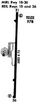
| Runways: | 18/36 |
| Longest Runway: | 18/36 is 5003 ft (1525 m) long |
| Runways with an Instrument Approach: |
KBGF Airport Runway Details
| Runway 18/36 | 5003 ft x 75 ft (1525 m x 23 m) | |
| Runway Length Source: | 3RD PARTY SURVEY as of 08/10/2018 | |
| Surface: | Asphalt - Good condition - No special surface treatment | |
| Runway Pavement Class: | 25 /F/B/X/T | |
| Runway Edge Lights: | Medium Intensity | |
Runway Weight Bearing Capacity (in thousands of pounds) |
||
| Single Wheel Landing Gear: | 30.0 | |
| Dual Wheel Landing Gear: | 42.0 | |
Runway 18 |
Runway 36 |
|
Elevation: |
971.6 | 975.1 |
Latitude: |
35-11-03.8476N | 35-10-14.3944N |
Longitude: |
086-03-57.2968W | 086-03-59.1004W |
|
Runway True Alignment: |
182 | 002 |
Glide Path Angle: |
3.5 degrees | 3.5 degrees |
Traffic Pattern: |
Left | Left |
Runway Markings Type: |
Nonprecision Instrument | Nonprecision Instrument |
Runway Markings Condition: |
Fair | Fair |
Object at End: |
TREES | TREES |
Object Height: |
114 | 47 |
Distance from End: |
2846 | 1249 |
Object Centerline Offset: |
71 ft. left of centerline | 300 ft. left of centerline |
Visual Glide Slope Indicators: |
2-Light PAPI On Left Side Of Runway | 2-Light PAPI On Left Side Of Runway |
REIL: |
Yes | Yes |
Threshold Crossing Height: |
29 | 32 |
Services
Airframe Repair: |
Major |
Powerplant Repair: |
Major |
Bottled Oxygen: |
None |
Bulk Oxygen: |
None |
Fuel Available: |
100LL, Jet A+ |
Landing Fees: |
No |
Parking: |
Hangars and tiedowns available |
Maps & Diagrams
KBGF Sectional
Flight Planning
at skyvector.com
at skyvector.com