Location
Latitude: |
35-08-10.4410N (35.136234) |
Longitude: |
092-42-49.3500W (-92.713708) |
Elevation: |
321.4 feet MSL (98 m MSL) |
Magnetic Variation: |
0 E (as of April 2024 from WMM2020 model) |
Time Zone: |
UTC -6.0 (Standard Time) UTC -5.0 (Daylight Savings Time) |
From City: |
02 N.M. SE of Morrilton, Arkansas |
Found On: |
Memphis Chart |
FAA Region: |
ASW |
Contacts
Manager: |
Publicly owned: |
| GLEN CASTO 1 AIRPORT ROAD MORRILTON, AR 72110 (501) 306-5656 |
CITY OF MORRILTON PO BOX 438 MORRILTON, AR 72110 501-354-3484 |
Operations
Airport Status: |
Operational |
Facility Use: |
Public |
Type: |
Airport |
Activation Date: |
05/1982 |
Control tower: |
No |
Attendance (Months/Days/Hours): |
Months/Days/Hours ALL/ALL/0800-1800 |
Boundary ARTCC: |
ZME (Memphis) |
Responsible ARTCC: |
ZME (Memphis) |
Lighting Schedule: |
SEE RMK |
Segmented Circle Indicator: |
Yes |
Traffic Pattern Altitude (MSL): |
1321 feet (403 m) |
NOTAMs Facility: |
JBR |
NOTAM-D Service: |
Yes |
Military Landing Rights: |
Yes |
Based Aircraft
| Single Engine: | 26 |
| GA Helicopters: | 1 |
Annual Operations (as of 10/31/2021)
| Total Operations: | 7900 | |
| GA Local: | 4500 | 57.0% |
| GA Itinerant: | 3000 | 38.0% |
| Military Aircraft: | 400 | 5.1% |
Communications
| CTAF: | 122.800 |
| Unicom: | 122.800 |
- APCH/DEP SVC PRVDD BY MEMPHIS ARTCC ON FREQS 128.475/377.15 (RUSSELLVILLE RCAG).
Fixed Based Operators (FBOs) & Fuel
(Click on a business for detail)
Please help us keep this information up to date. This is a FREE SERVICE just like everything else on Airport Guide! If you see that a business needs to be added, modified, or deleted please fill out our Update Form.
To add, modify, or delete a business click here.
Please help us keep this information up to date. This is a FREE SERVICE just like everything else on Airport Guide! If you see that a business needs to be added, modified, or deleted please fill out our Update Form.
Area Code: 501 |
| Business Name | Frequency | Phone | Fuel Grade |
|---|
Flight Service Stations
| Primary | Alternate | |
| FSS on Field: | N | |
| FSS Name (ID): | Jonesboro(JBR) | |
| Frequency: | ||
| Toll Free Phone: | 1-800-WX-BRIEF |
Instrument Procedures / Charts
FAA Terminal Procedures valid from 0901Z 03/21/24 to 0901Z 04/18/24.
There are various types of charts available for an airport. They are listed in the Page Type column. Here is a legend for those types:
APD - Airport Diagram
DP - Departure Procedure Charts
HOT - Hot Spots
IAP - Instrument Approach Procedure Charts
MIN - Minimums
STAR - Standard Terminal Arrival Charts
| Page Type | Page Name | Volume | Action Since Last Cycle |
|---|---|---|---|
| IAP | RNAV (GPS) RWY 27 | SC-1 | |
| MIN | TAKEOFF MINIMUMS | SC-1 |
Terminal Procedures are only available for airports in several countries with more being added all the time. If you are looking for a specific country's charts, please send an email to support(at)airportguide.com stating the country name. This will be used to prioritize the implementation.
Navigation Aids (Navaids) near KBDQ
| Dist (NM) | ID | Morse Code | Name | Type | Freq | True Hdg | Mag Hdg |
|---|---|---|---|---|---|---|---|
| 10.4 | MPJ | _ _ . _ _ . . _ _ _ | Morrilton | NDB | 410 | 264 | 264 |
| 14.4 | CWS | _ . _ . . _ _ . . . | Conway | NDB | 302 | 102 | 102 |
| 20.0 | RUE | . _ . . . _ . | Russellville | NDB | 379 | 291 | 291 |
| 30.3 | LRF | . _ . . . _ . . . _ . | Jacksonville | TACAN | 109.20 | 115 | 115 |
| 34.5 | LI | . _ . . . . | Lasky | NDB | 353 | 144 | 144 |
| 35.8 | TYV | _ _ . _ _ . . . _ | Toneyville | NDB | 290 | 107 | 107 |
| 38.0 | LIT | . _ . . . . _ | Little Rock | VORTAC | 113.90 | 136 | 136 |
| 40.1 | CZE | _ . _ . _ _ . . . | Clarksville | NDB | 201 | 300 | 300 |
| 43.6 | HOT | . . . . _ _ _ _ | Hot Springs | VOR-DME | 110.00 | 205 | 205 |
| 46.7 | DS | _ . . . . . | Cercy | NDB | 375 | 90 | 90 |
| 48.8 | HO | . . . . _ _ _ | Hossy | NDB | 385 | 208 | 208 |
| 56.2 | BV | _ . . . . . . _ | Almnd | NDB | 335 | 52 | 52 |
| 62.1 | SGT | . . . _ _ . _ | Stuttgart | NDB | 269 | 116 | 116 |
| 66.0 | PBF | . _ _ . _ . . . . . _ . | Pine Bluff | VOR-DME | 116.00 | 143 | 143 |
| 66.9 | HR | . . . . . _ . | Bakky | NDB | 395 | 341 | 341 |
| 67.4 | TT | _ _ | Stutt | NDB | 338 | 123 | 123 |
| 67.7 | ADF | . _ _ . . . . _ . | Arkadelphia | NDB | 275 | 196 | 196 |
| 70.9 | FLP | . . _ . . _ . . . _ _ . | Flippin | DME | 116.05 | 10 | 10 |
| 74.8 | FS | . . _ . . . . | Wizer | NDB | 223 | 280 | 280 |
| 75.0 | HRO | . . . . . _ . _ _ _ | Harrison | VOR-DME | 112.50 | 341 | 341 |
Nearby Airports with Fuel
Notices to Airmen (NOTAMS)
Remarks
| A110-1 | ULTRALIGHT ACTIVITY ON & INVOF ARPT. |
| A110-2 | DEER ON & INVOF ARPT. |
| A110-3 | FOR CD CTC MEMPHIS ARTCC AT 901-368-8453/8449. |
| A110-4 | FOR AFTER HRS SVC PLEASE CALL 501-306-5656. |
| A42-09 | RUNWAY MAKINGS FADED 9 AND 27. |
| A42-27 | RUNWAY MAKINGS FADED 9 AND 27 |
| A70-FUEL-10 | 0LL JET A & 100LL FUEL SELF SVC WITH CREDIT CARD. |
| A81-APT | ACTVT MIRL RWY 09/27 - 122.9. |
Runways
Runway Summary
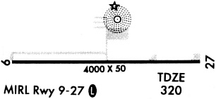
| Runways: | 09/27 |
| Longest Runway: | 09/27 is 3998 ft (1219 m) long |
| Runways with an Instrument Approach: |
KBDQ Airport Runway Details
| Runway 09/27 | 3998 ft x 75 ft (1219 m x 23 m) | |
| Runway Length Source: | 3RD PARTY SURVEY as of 01/18/2019 | |
| Surface: | Asphalt - Good condition - No special surface treatment | |
| Runway Edge Lights: | Medium Intensity | |
Runway Weight Bearing Capacity (in thousands of pounds) |
||
| Single Wheel Landing Gear: | 4.0 | |
Runway 09 |
Runway 27 |
|
Elevation: |
321.4 | 310.1 |
Latitude: |
35-08-10.6021N | 35-08-10.2791N |
Longitude: |
092-43-13.4174W | 092-42-25.2819W |
|
Runway True Alignment: |
090 | 270 |
Glide Path Angle: |
0.0 degrees | 0.0 degrees |
Runway Markings Type: |
Nonprecision Instrument | Nonprecision Instrument |
Runway Markings Condition: |
Poor | Poor |
Object at End: |
TREE | TREES |
Object Height: |
40 | 50 |
Distance from End: |
975 | 1750 |
Object Centerline Offset: |
125 ft. right of centerline | 0 ft. left and right of centerline |
Services
Airframe Repair: |
Minor |
Powerplant Repair: |
Minor |
Bottled Oxygen: |
None |
Bulk Oxygen: |
None |
Fuel Available: |
100LL, Jet A |
Landing Fees: |
No |
Parking: |
Hangars and tiedowns available |
Maps & Diagrams
KBDQ Sectional
Flight Planning
at skyvector.com
at skyvector.com