Location
Latitude: |
41-14-26.1890N (41.240608) |
Longitude: |
096-35-40.3980W (-96.594555) |
Elevation: |
1223.7 feet MSL (373 m MSL) |
Magnetic Variation: |
2.6 E (as of April 2024 from WMM2020 model) |
Time Zone: |
UTC -6.0 (Standard Time) UTC -5.0 (Daylight Savings Time) |
From City: |
02 N.M. NE of Wahoo, Nebraska |
Found On: |
Omaha Chart |
FAA Region: |
ACE |
Contacts
Manager: |
Publicly owned: |
| EVAN TAYLOR PO BOX 122 WAHOO, NE 68066-0122 (402) 882-2717 |
WAHOO AIRPORT AUTHORITY PO BOX 122 WAHOO, NE 68066-0122 402-443-3222 |
Operations
Airport Status: |
Operational |
Facility Use: |
Public |
Type: |
Airport |
Activation Date: |
01/1947 |
Control tower: |
No |
Attendance (Months/Days/Hours): |
Months/Days/Hours ALL/ALL/DAWN-DUSK |
Boundary ARTCC: |
ZMP (Minneapolis) |
Responsible ARTCC: |
ZMP (Minneapolis) |
Lighting Schedule: |
SEE RMK |
Segmented Circle Indicator: |
Yes |
Traffic Pattern Altitude (MSL): |
2224 feet (678 m) |
NOTAMs Facility: |
OLU |
NOTAM-D Service: |
Yes |
International Airport of Entry: |
No |
Customs Landing Rights: |
No |
Military Landing Rights: |
Yes |
Civil/Military Joint Use: |
No |
Based Aircraft
| Single Engine: | 30 |
| Multi Engine: | 2 |
| Jet Engine: | 1 |
| GA Helicopters: | 1 |
Annual Operations (as of 08/17/2023)
| Total Operations: | 16350 | |
| GA Local: | 11550 | 70.6% |
| GA Itinerant: | 4650 | 28.4% |
| Military Aircraft: | 150 | 0.9% |
Communications
| CTAF: | 122.700 |
| Unicom: | 122.700 |
| Approach: | OMAHA 120.1 120.1 |
| Departure: | OMAHA 120.1 120.1 |
| AWOS-3P: | 125.975 (402-443-4030) |
Fixed Based Operators (FBOs) & Fuel
(Click on a business for detail)
Please help us keep this information up to date. This is a FREE SERVICE just like everything else on Airport Guide! If you see that a business needs to be added, modified, or deleted please fill out our Update Form.
To add, modify, or delete a business click here.
Please help us keep this information up to date. This is a FREE SERVICE just like everything else on Airport Guide! If you see that a business needs to be added, modified, or deleted please fill out our Update Form.
Area Code: 402 |
| Business Name | Frequency | Phone | Fuel Grade |
|---|---|---|---|
| J & D Aircraft Service Co.
Update FBO info |
Unicom 122.7 | 443-3803 | 80, 100LL |
Flight Service Stations
| Primary | Alternate | |
| FSS on Field: | N | |
| FSS Name (ID): | Columbus(OLU) | |
| Frequency: | ||
| Toll Free Phone: | 1-800-WX-BRIEF |
Instrument Procedures / Charts
FAA Terminal Procedures valid from 0901Z 03/21/24 to 0901Z 04/18/24.
There are various types of charts available for an airport. They are listed in the Page Type column. Here is a legend for those types:
APD - Airport Diagram
DP - Departure Procedure Charts
HOT - Hot Spots
IAP - Instrument Approach Procedure Charts
MIN - Minimums
STAR - Standard Terminal Arrival Charts
| Page Type | Page Name | Volume | Action Since Last Cycle |
|---|---|---|---|
| IAP | NDB RWY 20 | NC-2 | |
| IAP | RNAV (GPS) RWY 20 | NC-2 | |
| MIN | ALTERNATE MINIMUMS | NC-2 | |
| MIN | TAKEOFF MINIMUMS | NC-2 |
Terminal Procedures are only available for airports in several countries with more being added all the time. If you are looking for a specific country's charts, please send an email to support(at)airportguide.com stating the country name. This will be used to prioritize the implementation.
Navigation Aids (Navaids) near KAHQ
| Dist (NM) | ID | Morse Code | Name | Type | Freq | True Hdg | Mag Hdg |
|---|---|---|---|---|---|---|---|
| 0.2 | AHQ | . _ . . . . _ _ . _ | Wahoo | NDB | 400 | 244 | 241 |
| 20.1 | LNK | . _ . . _ . _ . _ | Lincoln | VORTAC | 116.10 | 199 | 196 |
| 21.9 | MLE | _ _ . _ . . . | Millard | NDB | 371 | 97 | 95 |
| 21.9 | SCB | . . . _ . _ . _ . . . | Scribner | VOR-DME | 111.00 | 355 | 352 |
| 29.7 | OM | _ _ _ _ _ | Gerfi | NDB | 320 | 75 | 73 |
| 30.6 | LN | . _ . . _ . | Potts | NDB | 385 | 194 | 191 |
| 32.1 | OMA | _ _ _ _ _ . _ | Omaha | VOT | 109.00 | 83 | 81 |
| 32.2 | OFF | _ _ _ . . _ . . . _ . | Offutt | TACAN | 111.70 | 103 | 101 |
| 32.6 | SWT | . . . . _ _ _ | Seward | NDB | 269 | 225 | 222 |
| 35.1 | EN | . _ . | Rikky | NDB | 426 | 91 | 89 |
| 35.6 | PMV | . _ _ . _ _ . . . _ | Plattsmouth | NDB | 329 | 119 | 117 |
| 35.9 | OLU | _ _ _ . _ . . . . _ | Columbus | VOR-DME | 111.80 | 290 | 287 |
| 36.3 | TQE | _ _ _ . _ . | Tekamah | VOR | 108.40 | 30 | 28 |
| 38.6 | PLT | . _ _ . . _ . . _ | Platte Center | NDB | 407 | 293 | 290 |
| 39.0 | OVR | _ _ _ . . . _ . _ . | Omaha | VORTAC | 116.30 | 96 | 94 |
| 50.6 | AFK | . _ . . _ . _ . _ | Nebraska City | NDB | 347 | 138 | 136 |
| 50.6 | JYR | . _ _ _ _ . _ _ . _ . | York | NDB | 257 | 246 | 243 |
| 55.6 | OF | _ _ _ . . _ . | Carsy | NDB | 510 | 314 | 311 |
| 56.8 | BIE | _ . . . . . . | Beatrice | VOR | 110.60 | 187 | 184 |
| 58.6 | OFK | _ _ _ . . _ . _ . _ | Norfolk | VOR-DME | 109.60 | 320 | 317 |
Nearby Airports with Fuel
Notices to Airmen (NOTAMS)
Remarks
| A11 | JAY MORROW - ARPT AUTH CHAIRMAN. |
| A110-1 | RY 13/31 NOT PLOWED WINTER MONTHS. |
| A110-2 | FOR CD CTC OMAHA APCH AT 402-682-4395. |
| A17 | FOR SVC AFT DUSK CALL 402-882-2717. |
| A52-02 | ELEVATOR LEG. |
| A57-02 | RWY 02 HWY 850 FT FM END 0B ALSO 36:1. |
| A70-FUEL-10 | 0LL FUEL AVBL 24 HR SELF SERVE. |
| A81-APT | ACTVT REIL RWY 02 & 20; PAPI RWY 02 & 20; MIRL 02/20 - CTAF. |
Runways
Runway Summary
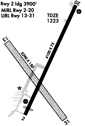
| Runways: | 02/20 13/31 |
| Longest Runway: | 02/20 is 4100 ft (1250 m) long |
| Runways with an Instrument Approach: |
KAHQ Airport Runway Details
| Runway 02/20 | 4100 ft x 75 ft (1250 m x 23 m) | |
| Runway Length Source: | 3RD PARTY SURVEY as of 07/17/2007 | |
| Surface: | Concrete - Good condition - No special surface treatment | |
| Runway Edge Lights: | Medium Intensity | |
Runway Weight Bearing Capacity (in thousands of pounds) |
||
| Single Wheel Landing Gear: | 20.0 | |
Runway 02 |
Runway 20 |
|
Elevation: |
1220.1 | 1223.7 |
Latitude: |
41-14-12.0928N | 41-14-49.1012N |
Longitude: |
096-35-48.3060W | 096-35-26.4813W |
|
Runway True Alignment: |
024 | 204 |
Glide Path Angle: |
3.0 degrees | 3.0 degrees |
Traffic Pattern: |
Left | Left |
Runway Markings Type: |
Nonprecision Instrument | Nonprecision Instrument |
Runway Markings Condition: |
Good | Good |
Visual Glide Slope Indicators: |
2-Light PAPI On Left Side Of Runway | 2-Light PAPI On Left Side Of Runway |
REIL: |
Yes | Yes |
Threshold Crossing Height: |
40 | 40 |
| Runway 13/31 | 3290 ft x 150 ft (1003 m x 46 m) | |
| Surface: | Concrete - Good condition - No special surface treatment | |
Runway 13 |
Runway 31 |
|
Elevation: |
1223.0 | 1220.0 |
Latitude: |
41-14-33.3580N | 41-14-08.0350N |
Longitude: |
096-35-57.6530W | 096-35-30.6300W |
|
Runway True Alignment: |
141 | 321 |
Glide Path Angle: |
0.0 degrees | 0.0 degrees |
Traffic Pattern: |
Left | Left |
Services
Airframe Repair: |
Minor |
Powerplant Repair: |
Minor |
Bottled Oxygen: |
None |
Bulk Oxygen: |
None |
Fuel Available: |
100LL, Jet A |
Landing Fees: |
No |
Parking: |
Hangars and tiedowns available |
Other Services: |
Manager gives aerobatic instruction |
Maps & Diagrams
KAHQ Sectional
Flight Planning
at skyvector.com
at skyvector.com