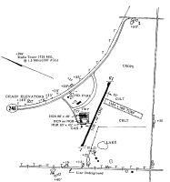
Location
Latitude: |
39-54-19.6000N (39.905444) |
Longitude: |
095-46-36.1000W (-95.776694) |
Elevation: |
1327.6 feet MSL (405 m MSL) |
Magnetic Variation: |
2 E (as of April 2024 from WMM2020 model) |
Time Zone: |
UTC -6.0 (Standard Time) UTC -5.0 (Daylight Savings Time) |
From City: |
01 N.M. E of Sabetha, Kansas |
Found On: |
Kansas City Chart |
FAA Region: |
ACE |
Contacts
Manager: |
Publicly owned: |
| DOUG ALLEN - CITY ADMINISTRATOR 805 MAIN SABETHA, KS 66534 785-284-2158 |
CITY OF SABETHA PO BOX 187 SABETHA, KS 66534 785-284-2158 |
Operations
Airport Status: |
Operational |
Facility Use: |
Public |
Type: |
Airport |
Activation Date: |
10/1949 |
Control tower: |
No |
Attendance (Months/Days/Hours): |
Months/Days/Hours Unattended |
Boundary ARTCC: |
ZKC (Kansas City) |
Responsible ARTCC: |
ZKC (Kansas City) |
Segmented Circle Indicator: |
No |
Traffic Pattern Altitude (MSL): |
2328 feet (710 m) |
NOTAMs Facility: |
ICT |
NOTAM-D Service: |
Yes |
International Airport of Entry: |
No |
Customs Landing Rights: |
No |
Military Landing Rights: |
No |
Civil/Military Joint Use: |
No |
Based Aircraft
| Single Engine: | 10 |
| GA Helicopters: | 1 |
Annual Operations (as of 08/31/2020)
| Total Operations: | 4800 | |
| GA Local: | 3000 | 62.5% |
| GA Itinerant: | 1800 | 37.5% |
Communications
| CTAF: | 122.900 |
| AWOS-3P: | 118.475 (785-284-2201) |
Fixed Based Operators (FBOs) & Fuel
(Click on a business for detail)
Please help us keep this information up to date. This is a FREE SERVICE just like everything else on Airport Guide! If you see that a business needs to be added, modified, or deleted please fill out our Update Form.
To add, modify, or delete a business click here.
Please help us keep this information up to date. This is a FREE SERVICE just like everything else on Airport Guide! If you see that a business needs to be added, modified, or deleted please fill out our Update Form.
Area Code: 785 |
| Business Name | Frequency | Phone | Fuel Grade |
|---|---|---|---|
| City of Sabetha
Update FBO info |
284-2158 | 100LL |
Flight Service Stations
| Primary | Alternate | |
| FSS on Field: | N | |
| FSS Name (ID): | Wichita(ICT) | |
| Frequency: | ||
| Toll Free Phone: | 1-800-WX-BRIEF |
Instrument Procedures / Charts
Terminal Procedures are only available for airports in several countries with more being added all the time. If you are looking for a specific country's charts, please send an email to support(at)airportguide.com stating the country name. This will be used to prioritize the implementation.
Navigation Aids (Navaids) near K83
| Dist (NM) | ID | Morse Code | Name | Type | Freq | True Hdg | Mag Hdg |
|---|---|---|---|---|---|---|---|
| 13.5 | FNB | . . _ . _ . _ . . . | Brenner | NDB | 404 | 40 | 38 |
| 16.6 | RBA | . _ . _ . . . . _ | Robinson | DME | 108.2 | 101 | 99 |
| 26.5 | PWE | . _ _ . . _ _ . | Pawnee City | DME | 112.4 | 312 | 310 |
| 39.3 | STJ | . . . _ . _ _ _ | St Joseph | VORTAC | 115.50 | 84 | 82 |
| 40.0 | AZN | . _ _ _ . . _ . | Amazon | NDB | 233 | 91 | 89 |
| 42.2 | AFK | . _ . . _ . _ . _ | Nebraska City | NDB | 347 | 354 | 352 |
| 42.4 | ST | . . . _ | Tario | NDB | 260 | 108 | 106 |
| 47.3 | TO | _ _ _ _ | Biloy | NDB | 521 | 174 | 172 |
| 47.3 | TOP | _ _ _ _ . _ _ . | Topeka | VORTAC | 117.80 | 167 | 165 |
| 50.8 | BIE | _ . . . . . . | Beatrice | VOR | 110.60 | 298 | 296 |
| 53.5 | SDA | . . . _ . . . _ | Shenandoah | NDB | 411 | 18 | 16 |
| 57.5 | FOE | . . _ . _ _ _ . | Forbes | VOT | 111.00 | 174 | 172 |
| 57.7 | FOE | . . _ . _ _ _ . | Forbes | TACAN | 111.60 | 174 | 172 |
| 59.9 | ICL | . . _ . _ . . _ . . | Clarinda | NDB | 353 | 34 | 32 |
| 60.8 | MCI | _ _ _ . _ . . . | Kansas City | VORTAC | 113.25 | 127 | 125 |
| 61.5 | MHK | _ _ . . . . _ . _ | Manhattan | VOR-DME | 110.20 | 222 | 220 |
| 61.9 | FO | . . _ . _ _ _ | Riply | NDB | 326 | 171 | 169 |
| 62.6 | PMV | . _ _ . _ _ . . . _ | Plattsmouth | NDB | 329 | 354 | 352 |
| 62.8 | DO | _ . . _ _ _ | Dotte | NDB | 359 | 130 | 128 |
| 65.9 | FBY | . . _ . _ . . . _ . _ _ | Fairbury | NDB | 293 | 284 | 282 |
Nearby Airports with Fuel
Notices to Airmen (NOTAMS)
Remarks
| A110*G | THIS AIRPORT HAS BEEN SURVEYED BY THE NATIONAL GEODETIC SURVEY. |
| A110-1 | FOR CD CTC ST JOSEPH APCH AT 816-236-3035. WHEN ST JOSEPH APCH IS CLSD, CTC KANSAS CITY ARTCC AT 913-254-8508. |
| A70-FUEL-10 | 0LL 24 HR FUEL AVBL WITH CREDIT CARD. |
| A75 | CALL FOR TRANSIENT HGR AVAILABILITY. |
Runways
Runway Summary
| Runways: | 01/19 |
| Longest Runway: | 01/19 is 3208 ft (978 m) long |
| Runways with an Instrument Approach: |
K83 Airport Runway Details
| Runway 01/19 | 3208 ft x 40 ft (978 m x 12 m) | |
| Runway Length Source: | NGS as of 12/06/2022 | |
| Surface: | Asphalt - Fair condition - No special surface treatment | |
| Runway Pavement Class: | 4 /F/C/Y/U | |
| Runway Edge Lights: | Low Intensity | |
Runway Weight Bearing Capacity (in thousands of pounds) |
||
| Single Wheel Landing Gear: | 6.0 | |
Runway 01 |
Runway 19 |
|
Elevation: |
1320.4 | 1325.4 |
Latitude: |
39-54-04.8064N | 39-54-34.3979N |
Longitude: |
095-46-43.5035W | 095-46-28.7317W |
Glide Path Angle: |
0.0 degrees | 0.0 degrees |
Traffic Pattern: |
Left | Left |
Runway Markings Type: |
Basic | Basic |
Runway Markings Condition: |
Fair | Fair |
Services
Airframe Repair: |
Major |
Powerplant Repair: |
Major |
Bottled Oxygen: |
None |
Bulk Oxygen: |
None |
Fuel Available: |
100LL |
Landing Fees: |
No |
Parking: |
Tiedowns available |
Maps & Diagrams
K83 Sectional
Flight Planning
at skyvector.com
at skyvector.com