Location
Latitude: |
38-16-38.3000N (38.277306) |
Longitude: |
095-12-54.8000W (-95.215222) |
Elevation: |
988.6 feet MSL (301 m MSL) |
Magnetic Variation: |
1.6 E (as of April 2024 from WMM2020 model) |
Time Zone: |
UTC -6.0 (Standard Time) UTC -5.0 (Daylight Savings Time) |
From City: |
02 N.M. E of Garnett, Kansas |
Found On: |
Kansas City Chart |
FAA Region: |
ACE |
Contacts
Manager: |
Publicly owned: |
| PAT SCHETTLER 1202 E 4TH ST ROAD GARNETT, KS 66032 785-448-6931 |
CITY OF GARNETT 131 W 5TH GARNETT, KS 66032 785-448-5496 |
Operations
Airport Status: |
Operational |
Facility Use: |
Public |
Type: |
Airport |
Activation Date: |
11/1949 |
Control tower: |
No |
Attendance (Months/Days/Hours): |
Months/Days/Hours ALL/SAT - SUN/ON CALL |
Boundary ARTCC: |
ZKC (Kansas City) |
Responsible ARTCC: |
ZKC (Kansas City) |
Segmented Circle Indicator: |
No |
Traffic Pattern Altitude (MSL): |
1989 feet (606 m) |
NOTAMs Facility: |
ICT |
NOTAM-D Service: |
Yes |
International Airport of Entry: |
No |
Customs Landing Rights: |
No |
Civil/Military Joint Use: |
No |
Based Aircraft
| Single Engine: | 14 |
| Multi Engine: | 1 |
| GA Helicopters: | 1 |
Annual Operations (as of 09/12/2018)
| Total Operations: | 1520 | |
| GA Local: | 1200 | 78.9% |
| GA Itinerant: | 300 | 19.7% |
| Military Aircraft: | 20 | 1.3% |
Communications
| CTAF: | 122.800 |
| Unicom: | 122.800 |
Fixed Based Operators (FBOs) & Fuel
(Click on a business for detail)
Please help us keep this information up to date. This is a FREE SERVICE just like everything else on Airport Guide! If you see that a business needs to be added, modified, or deleted please fill out our Update Form.
To add, modify, or delete a business click here.
Please help us keep this information up to date. This is a FREE SERVICE just like everything else on Airport Guide! If you see that a business needs to be added, modified, or deleted please fill out our Update Form.
Area Code: 785 |
| Business Name | Frequency | Phone | Fuel Grade |
|---|---|---|---|
| Roy Baker Flying Service
Update FBO info |
Unicom 122.8 | 448-6931 | 100LL |
Flight Service Stations
| Primary | Alternate | |
| FSS on Field: | N | |
| FSS Name (ID): | Wichita(ICT) | |
| Frequency: | ||
| Toll Free Phone: | 1-800-WX-BRIEF |
Instrument Procedures / Charts
Terminal Procedures are only available for airports in several countries with more being added all the time. If you are looking for a specific country's charts, please send an email to support(at)airportguide.com stating the country name. This will be used to prioritize the implementation.
Navigation Aids (Navaids) near K68
| Dist (NM) | ID | Morse Code | Name | Type | Freq | True Hdg | Mag Hdg |
|---|---|---|---|---|---|---|---|
| 23.9 | UKL | . . _ _ . _ . _ . . | Boyd | NDB | 245 | 273 | 271 |
| 30.6 | MSB | _ _ . . . _ . . . | Monarch | NDB | 410 | 198 | 196 |
| 34.2 | BUM | _ . . . . . _ _ _ | Butler | VORTAC | 115.90 | 90 | 89 |
| 35.8 | FSK | . . _ . . . . _ . _ | Fort Scott | NDB | 379 | 143 | 142 |
| 36.3 | PK | . _ _ . _ . _ | Herbb | NDB | 420 | 38 | 37 |
| 38.3 | JZ | . _ _ _ _ _ . . | Newbn | NDB | 338 | 4 | 2 |
| 40.3 | FO | . . _ . _ _ _ | Riply | NDB | 326 | 334 | 332 |
| 40.6 | OJC | _ _ _ . _ _ _ _ . _ . | Johnson County | VOR-DME | 113.00 | 33 | 32 |
| 43.0 | CNU | _ . _ . _ . . . _ | Chanute | VOR-DME | 109.20 | 204 | 202 |
| 43.5 | EMP | . _ _ . _ _ . | Emporia | VORTAC | 112.80 | 271 | 269 |
| 45.3 | FOE | . . _ . _ _ _ . | Forbes | TACAN | 111.60 | 332 | 330 |
| 45.7 | FOE | . . _ . _ _ _ . | Forbes | VOT | 111.00 | 332 | 330 |
| 53.8 | GQ | _ _ . _ _ . _ | Norge | NDB | 517 | 28 | 27 |
| 53.9 | TOP | _ _ _ _ . _ _ . | Topeka | VORTAC | 117.80 | 343 | 341 |
| 55.2 | PTS | . _ _ . _ . . . | Pittsburg | NDB | 365 | 155 | 154 |
| 55.2 | TO | _ _ _ _ | Biloy | NDB | 521 | 336 | 334 |
| 58.3 | RIS | . _ . . . . . . | Riverside | VOR-DME | 111.40 | 29 | 28 |
| 58.4 | MKC | _ _ _ . _ _ . _ . | Kansas City Downtown | VOT | 108.60 | 29 | 28 |
| 60.7 | DO | _ . . _ _ _ | Dotte | NDB | 359 | 20 | 19 |
| 63.9 | LLU | . _ . . . _ . . . . _ | Spring River | NDB | 356 | 137 | 136 |
Nearby Airports with Fuel
Notices to Airmen (NOTAMS)
Remarks
| A110-1 | IF EMERG EXIST CALL 911 OR NIGHT OR EMERG 785-448-8067; FBO PHONE NUMBER 785-448-6931. |
| A110-2 | FOR CD CTC KANSAS CITY ARTCC AT 913-254-8508. |
| A16 | ARPT OFC DURG THE DAY 785-448-6931. |
| A17 | FOR ATTENDANT ON SAT & SUN CALL (785) 448-6931 OR (785) 448-8067. |
| A42-01 | RY 01/19 PVMT ENDS MKD WITH YELLOW & WHITE PANELS. |
| A57-19 | APCH SLOPE TO DSPLCD THLD 15:1 (ROAD). |
| A58-01 | +15 ROAD 35 FT FROM AER 01. |
| A58-19 | +15 FT ROAD 90 FT FM RY END. |
| A70-FUEL-10 | 0LL FUEL AVBL 24HRS WITH CREDIT CARD. |
| A84 | SEGMENTED CIRCLE NOT AVBL. |
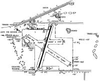
Runways
Runway Summary
| Runways: | 01/19 |
| Longest Runway: | 01/19 is 2653 ft (809 m) long |
| Runways with an Instrument Approach: |
K68 Airport Runway Details
| Runway 01/19 | 2653 ft x 45 ft (809 m x 14 m) | |
| Runway Length Source: | 3RD PARTY SURVEY as of 09/10/2018 | |
| Surface: | Asphalt - Good condition - No special surface treatment | |
| Runway Pavement Class: | 4 /F/C/Y/U | |
| Runway Edge Lights: | Low Intensity | |
Runway 01 |
Runway 19 |
|
Elevation: |
972.9 | 981.6 |
Latitude: |
38-16-25.6889N | 38-16-50.9245N |
Longitude: |
095-12-59.3397W | 095-12-50.2690W |
Glide Path Angle: |
0.0 degrees | 0.0 degrees |
Traffic Pattern: |
Left | |
Runway Markings Type: |
Basic | Basic |
Runway Markings Condition: |
Fair | Fair |
Object at End: |
TREES | |
Object Height: |
34 | |
Distance from End: |
628 | |
Object Centerline Offset: |
46 ft. left of centerline | |
Threshold Elevation: |
973.8 | 983.2 |
Displaced Threshold: |
86 | 133 |
Threshold Latitude: |
38-16-26.5067N | 38-16-49.6649N |
Threshold Longitude: |
095-12-59.0332W | 095-12-50.7264W |
Services
Airframe Repair: |
None |
Powerplant Repair: |
None |
Bottled Oxygen: |
None |
Bulk Oxygen: |
None |
Fuel Available: |
100LL |
Landing Fees: |
No |
Parking: |
Tiedowns available |
Maps & Diagrams
K68 Sectional
Flight Planning
at skyvector.com
at skyvector.com