Location
Latitude: |
39-34-13.8890N (39.570525) |
Longitude: |
095-10-49.1930W (-95.180331) |
Elevation: |
1073.0 feet MSL (327 m MSL) |
Magnetic Variation: |
1.6 E (as of April 2024 from WMM2020 model) |
Time Zone: |
UTC -6.0 (Standard Time) UTC -5.0 (Daylight Savings Time) |
From City: |
02 N.M. W of Atchison, Kansas |
Found On: |
Kansas City Chart |
FAA Region: |
ACE |
Contacts
Manager: |
Publicly owned: |
| CLINTON MCNEMEE 515 KANSAS AVE ATCHISON, KS 66002 913-426-0311 |
CITY OF ATCHISON 515 KANSAS AVE ATCHISON, KS 66002 913-367-5500 |
Operations
Airport Status: |
Operational |
Facility Use: |
Public |
Type: |
Airport |
Activation Date: |
06/1952 |
Control tower: |
No |
Attendance (Months/Days/Hours): |
Months/Days/Hours ALL/ALL/0900-1900 |
Boundary ARTCC: |
ZKC (Kansas City) |
Responsible ARTCC: |
ZKC (Kansas City) |
Lighting Schedule: |
SEE RMK |
Segmented Circle Indicator: |
No |
Traffic Pattern Altitude (MSL): |
2073 feet (632 m) |
NOTAMs Facility: |
ICT |
NOTAM-D Service: |
Yes |
International Airport of Entry: |
No |
Customs Landing Rights: |
No |
Military Landing Rights: |
Yes |
Civil/Military Joint Use: |
No |
Based Aircraft
| Single Engine: | 21 |
| Multi Engine: | 2 |
| Gliders: | 1 |
Annual Operations (as of 09/27/2022)
| Total Operations: | 16100 | |
| Air Taxi: | 50 | 0.3% |
| GA Local: | 11000 | 68.3% |
| GA Itinerant: | 5000 | 31.1% |
| Military Aircraft: | 50 | 0.3% |
Communications
| CTAF: | 122.800 |
| Unicom: | 122.800 |
| Approach: | ST JOSEPH 124.7 124.7 124.7 124.7 KANSAS CITY |
| Departure: | ST JOSEPH 124.7 124.7 124.7 124.7 KANSAS CITY |
| AWOS-3PT: | 123.675 (913-367-1449) |
Fixed Based Operators (FBOs) & Fuel
(Click on a business for detail)
Please help us keep this information up to date. This is a FREE SERVICE just like everything else on Airport Guide! If you see that a business needs to be added, modified, or deleted please fill out our Update Form.
To add, modify, or delete a business click here.
Please help us keep this information up to date. This is a FREE SERVICE just like everything else on Airport Guide! If you see that a business needs to be added, modified, or deleted please fill out our Update Form.
Area Code: 913 |
| Business Name | Frequency | Phone | Fuel Grade |
|---|
Flight Service Stations
| Primary | Alternate | |
| FSS on Field: | N | |
| FSS Name (ID): | Wichita(ICT) | |
| Frequency: | ||
| Toll Free Phone: | 1-800-WX-BRIEF |
Instrument Procedures / Charts
FAA Terminal Procedures valid from 0901Z 03/21/24 to 0901Z 04/18/24.
There are various types of charts available for an airport. They are listed in the Page Type column. Here is a legend for those types:
APD - Airport Diagram
DP - Departure Procedure Charts
HOT - Hot Spots
IAP - Instrument Approach Procedure Charts
MIN - Minimums
STAR - Standard Terminal Arrival Charts
| Page Type | Page Name | Volume | Action Since Last Cycle |
|---|---|---|---|
| IAP | RNAV (GPS) RWY 16 | NC-2 | |
| MIN | TAKEOFF MINIMUMS | NC-2 |
Terminal Procedures are only available for airports in several countries with more being added all the time. If you are looking for a specific country's charts, please send an email to support(at)airportguide.com stating the country name. This will be used to prioritize the implementation.
Navigation Aids (Navaids) near K59
| Dist (NM) | ID | Morse Code | Name | Type | Freq | True Hdg | Mag Hdg |
|---|---|---|---|---|---|---|---|
| 14.1 | ST | . . . _ | Tario | NDB | 260 | 63 | 62 |
| 20.2 | RBA | . _ . _ . . . . _ | Robinson | DME | 108.2 | 326 | 324 |
| 22.6 | AZN | . _ _ _ . . _ . | Amazon | NDB | 233 | 33 | 32 |
| 26.2 | STJ | . . . _ . _ _ _ | St Joseph | VORTAC | 115.50 | 26 | 25 |
| 26.7 | MCI | _ _ _ . _ . . . | Kansas City | VORTAC | 113.25 | 129 | 128 |
| 29.0 | DO | _ . . _ _ _ | Dotte | NDB | 359 | 136 | 135 |
| 31.1 | TOP | _ _ _ _ . _ _ . | Topeka | VORTAC | 117.80 | 213 | 211 |
| 35.7 | FNB | . . _ . _ . _ . . . | Brenner | NDB | 404 | 328 | 326 |
| 35.8 | TO | _ _ _ _ | Biloy | NDB | 521 | 221 | 219 |
| 38.1 | MKC | _ _ _ . _ _ . _ . | Kansas City Downtown | VOT | 108.60 | 134 | 133 |
| 38.2 | RIS | . _ . . . . . . | Riverside | VOR-DME | 111.40 | 134 | 133 |
| 39.1 | GQ | _ _ . _ _ . _ | Norge | NDB | 517 | 141 | 140 |
| 39.4 | JZ | . _ _ _ _ _ . . | Newbn | NDB | 338 | 178 | 176 |
| 43.5 | FOE | . . _ . _ _ _ . | Forbes | VOT | 111.00 | 211 | 209 |
| 43.6 | FOE | . . _ . _ _ _ . | Forbes | TACAN | 111.60 | 211 | 209 |
| 45.2 | FO | . . _ . _ _ _ | Riply | NDB | 326 | 204 | 202 |
| 48.4 | OJC | _ _ _ . _ _ _ _ . _ . | Johnson County | VOR-DME | 113.00 | 154 | 153 |
| 53.2 | PK | . _ _ . _ . _ | Herbb | NDB | 420 | 157 | 156 |
| 56.5 | ANX | . _ _ . _ . . _ | Napoleon | VORTAC | 114.00 | 119 | 118 |
| 60.4 | BQS | _ . . . _ _ . _ . . . | Braymer | VOR-DME | 115.35 | 86 | 85 |
Nearby Airports with Fuel
Notices to Airmen (NOTAMS)
Remarks
| A110*G | THIS AIRPORT HAS BEEN SURVEYED BY THE NATIONAL GEODETIC SURVEY. |
| A110-2 | GLIDER OPNS FM GRASS WEST SIDE OF RWY. |
| A110-3 | A HEAVY CROPDUSTING OPS. |
| A110-4 | FOR CD CTC KANSAS CITY APCH AT 816-329-2710. |
| A110-5 | CTN - ROAD AND TREES 15 - 55 FT AGL; 302 - 438 FT FM RWY 34 THLD; 0-225 FT L AND R. |
| A110-6 | (CONTACT TITLE) INTERIM CITY MGR BECKY BERGER, ALTN CLINTON MCNEMEE 913-367-5561. |
| A16 | ALT PH NUMBER 913-568-3819. |
| A30-16/34 | LN OF SIGHT OBSTD BTWN RWY ENDS. |
| A40-16/34 | RWY 16/34 NSTD LIRL; RY END LGTS AT DEP END RY 16 ARE NOT SPLIT LENSES. SOME EDGE LGTS OTS INDEFLY. |
| A57-34 | OBSTN CLNC SLOPE TO DSPLD THLD 50:1. |
| A70-FUEL-A+ | 24 HR SELF SVC FUEL AVBL. |
| A81-APT | ACTVT LIRL RWY 16/34 - CTAF. |
Runways
Runway Summary
| Runways: | 16/34 |
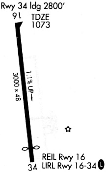
| Longest Runway: | 16/34 is 3000 ft (914 m) long |
| Runways with an Instrument Approach: |
K59 Airport Runway Details
| Runway 16/34 | 3000 ft x 48 ft (914 m x 15 m) | |
| Surface: | Asphalt - Fair condition - No special surface treatment | |
| Runway Pavement Class: | 7 /F/C/Y/U | |
| Runway Edge Lights: | Low Intensity | |
Runway Weight Bearing Capacity (in thousands of pounds) |
||
| Single Wheel Landing Gear: | 17.0 | |
Runway 16 |
Runway 34 |
|
Elevation: |
1040.0 | 1072.0 |
Latitude: |
39-34-28.6360N | 39-33-59.1850N |
Longitude: |
095-10-51.3430W | 095-10-46.9890W |
|
Runway True Alignment: |
173 | 353 |
Glide Path Angle: |
0.0 degrees | 0.0 degrees |
Traffic Pattern: |
Left | Left |
Runway Markings Type: |
Basic | Basic |
Runway Markings Condition: |
Good | Good |
Object at End: |
TREES | ROAD |
Object Height: |
60 | 15 |
Distance from End: |
1173 | 287 |
Object Centerline Offset: |
279 ft. right of centerline | 0 ft. left and right of centerline |
Threshold Elevation: |
1070.0 | |
Displaced Threshold: |
202 | |
Threshold Latitude: |
39-34-01.1500N | |
Threshold Longitude: |
095-10-47.2800W |
Services
Airframe Repair: |
Major |
Powerplant Repair: |
Major |
Fuel Available: |
MOGAS |
Landing Fees: |
No |
Parking: |
Tiedowns available |
Maps & Diagrams
K59 Sectional
Flight Planning
at skyvector.com
at skyvector.com