Location
Latitude: |
42-46-42.2670N (42.778408) |
Longitude: |
074-34-39.5040W (-74.57764) |
Elevation: |
1508.0 feet MSL (460 m MSL) |
Magnetic Variation: |
12.7 W (as of April 2024 from WMM2020 model) |
Time Zone: |
UTC -5.0 (Standard Time) UTC -4.0 (Daylight Savings Time) |
From City: |
02 N.M. SE of Sharon Springs, New York |
Found On: |
New York Chart |
FAA Region: |
AEA |
Contacts
Manager: |
Privately owned: |
| BRUCE POMELLA PO BOX 447 SHARON SPRINGS, NY 13459-0447 518-284-2081 |
SHARON AIR PARK INC PO BOX 447 SHARON SPRINGS, NY 13459-0447 518-284-2081 |
Operations
Airport Status: |
Operational |
Facility Use: |
Public |
Type: |
Airport |
Activation Date: |
09/1976 |
Control tower: |
No |
Attendance (Months/Days/Hours): |
Months/Days/Hours IREG |
Boundary ARTCC: |
ZBW (Boston) |
Responsible ARTCC: |
ZBW (Boston) |
Segmented Circle Indicator: |
No |
Traffic Pattern Altitude (MSL): |
2508 feet (764 m) |
NOTAMs Facility: |
BUF |
NOTAM-D Service: |
Yes |
Based Aircraft
| Single Engine: | 4 |
Annual Operations (as of 07/20/2017)
| Total Operations: | 450 | |
| GA Local: | 300 | 66.7% |
| GA Itinerant: | 100 | 22.2% |
| Military Aircraft: | 50 | 11.1% |
Communications
| CTAF: | 122.800 |
| Unicom: | 122.800 |
Fixed Based Operators (FBOs) & Fuel
(Click on a business for detail)
Please help us keep this information up to date. This is a FREE SERVICE just like everything else on Airport Guide! If you see that a business needs to be added, modified, or deleted please fill out our Update Form.
To add, modify, or delete a business click here.
Please help us keep this information up to date. This is a FREE SERVICE just like everything else on Airport Guide! If you see that a business needs to be added, modified, or deleted please fill out our Update Form.
Area Code: 518 |
| Business Name | Frequency | Phone | Fuel Grade |
|---|
Flight Service Stations
| Primary | Alternate | |
| FSS on Field: | N | |
| FSS Name (ID): | Buffalo(BUF) | |
| Frequency: | ||
| Toll Free Phone: | 1-800-WX-BRIEF |
Instrument Procedures / Charts
Terminal Procedures are only available for airports in several countries with more being added all the time. If you are looking for a specific country's charts, please send an email to support(at)airportguide.com stating the country name. This will be used to prioritize the implementation.
Navigation Aids (Navaids) near K31
| Dist (NM) | ID | Morse Code | Name | Type | Freq | True Hdg | Mag Hdg |
|---|---|---|---|---|---|---|---|
| 17.1 | JJH | . _ _ _ . _ _ _ . . . . | Johnstown | NDB | 523 | 39 | 52 |
| 21.5 | OZ | _ _ _ _ _ . . | Kring | NDB | 279 | 237 | 250 |
| 28.7 | HEU | . . . . . . . _ | Hunter | NDB | 356 | 80 | 93 |
| 29.8 | UCA | . . _ _ . _ . . _ | Utica | TACAN | 111.20 | 300 | 313 |
| 33.4 | ALB | . _ . _ . . _ . . . | Albany | VOT | 108.20 | 93 | 106 |
| 34.2 | ALB | . _ . _ . . _ . . . | Albany | VORTAC | 115.30 | 92 | 105 |
| 34.7 | RKA | . _ . _ . _ . _ | Rockdale | VOR-DME | 112.60 | 237 | 250 |
| 39.7 | DNY | _ . . _ . _ . _ _ | Delancey | VOR-DME | 112.10 | 205 | 218 |
| 49.2 | PFH | . _ _ . . . _ . . . . . | Philmont | NDB | 272 | 129 | 142 |
| 51.4 | GF | _ _ . . . _ . | Ganse | NDB | 209 | 55 | 68 |
| 54.0 | HNK | . . . . _ . _ . _ | Hancock | VOR-DME | 116.80 | 217 | 229 |
| 54.2 | GFL | _ _ . . . _ . . _ . . | Glens Falls | VORTAC | 110.20 | 51 | 64 |
| 55.0 | GGT | _ _ . _ _ . _ | Georgetown | TACAN | 117.80 | 271 | 283 |
| 55.8 | CAM | _ . _ . . _ _ _ | Cambridge | VOR-DME | 115.00 | 76 | 89 |
| 62.0 | MS | _ _ . . . | Monga | NDB | 359 | 191 | 204 |
| 63.0 | GBR | _ _ . _ . . . . _ . | Great Barrington | NDB | 395 | 124 | 137 |
| 70.8 | BG | _ . . . _ _ . | Smite | NDB | 332 | 235 | 247 |
| 74.5 | PWL | . _ _ . . _ _ . _ . . | Pawling | VOR-DME | 114.30 | 144 | 157 |
| 74.7 | IGN | . . _ _ . _ . | Kingston | VOR-DME | 117.60 | 153 | 166 |
| 75.0 | SYR | . . . _ . _ _ . _ . | Syracuse | VORTAC | 117.00 | 288 | 300 |
Nearby Airports with Fuel
Notices to Airmen (NOTAMS)
Remarks
| A110-1 | PLINE PARALLEL ON SW SIDE OF RWY 285 FT FROM RWY EDGE. |
| A110-2 | FOR CD CTC SYRACUSE APCH AT 315-455-6218. |
| A110-3 | TREES ENCROACHING NE SIDE OF RWY. |
| A17 | FOR FLD CONDITIONS CALL 518-284-2081. |
| A30-13/31 | RY SHORTENED BY 200 FT ON THE WEST END DUE TO TURF HOLES/CREVASES. |
| E111 | VFR USE ONLY. |
Runways
Runway Summary
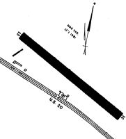
| Runways: | 13/31 |
| Longest Runway: | 13/31 is 2570 ft (783 m) long |
| Runways with an Instrument Approach: |
K31 Airport Runway Details
| Runway 13/31 | 2570 ft x 120 ft (783 m x 37 m) | |
| Surface: | Turf - Good condition - No special surface treatment | |
Runway 13 |
Runway 31 |
|
Glide Path Angle: |
0.0 degrees | 0.0 degrees |
Object at End: |
TREES | TREES |
Object Height: |
54 | 46 |
Distance from End: |
213 | 65 |
Object Centerline Offset: |
143 ft. right of centerline | 118 ft. right of centerline |
Displaced Threshold: |
200 |
Services
Airframe Repair: |
Major |
Powerplant Repair: |
Minor |
Bottled Oxygen: |
None |
Bulk Oxygen: |
None |
Fuel Available: |
100LL, Jet A |
Landing Fees: |
Yes |
Parking: |
Hangars and tiedowns available |
Maps & Diagrams
K31 Sectional
Flight Planning
at skyvector.com
at skyvector.com