
Location
Latitude: |
19-43-12.9468N (19.720263) |
Longitude: |
155-02-54.4925W (-155.04847) |
Elevation: |
37.6 feet MSL (11 m MSL) |
Magnetic Variation: |
9.5 E (as of April 2024 from WMM2020 model) |
Time Zone: |
UTC -10.0 (Standard Time) UTC -10.0 (Daylight Savings Time) |
From City: |
02 N.M. E of Hilo, Hawaii |
Found On: |
Hawaiian Islands Chart |
FAA Region: |
AWP |
Contacts
Manager: |
Publicly owned: |
| TIFFINIE C SMITH HAWAII AIRPORTS DISTRICT MANAGER, 2450 KEKUANAOA STREET #215 HILO, HI 96720 808-961-9300 |
STATE OF HAWAII ARPT DIV DOT HONOLULU INTL ARPT HONOLULU, HI 96819 808-838-8600 |
Operations
Airport Status: |
Operational |
Facility Use: |
Public |
Type: |
Airport |
Activation Date: |
04/1938 |
Control tower: |
Yes |
Attendance (Months/Days/Hours): |
Months/Days/Hours ALL/ALL/0700-2030 |
Boundary ARTCC: |
ZHN (Honolulu Control Facility) |
Responsible ARTCC: |
ZHN (Honolulu Control Facility) |
Lighting Schedule: |
SEE RMK |
Segmented Circle Indicator: |
Yes |
Traffic Pattern Altitude (MSL): |
1038 feet (316 m) |
NOTAMs Facility: |
ITO |
NOTAM-D Service: |
Yes |
International Airport of Entry: |
No |
Customs Landing Rights: |
Yes |
Military Landing Rights: |
Yes |
Civil/Military Joint Use: |
No |
Aircraft Rescue and Firefighting: |
Class I ARFF Index: C Air Carrier Service: Scheduled Certification Date: 05/1973 |
Based Aircraft
| Single Engine: | 10 |
| Multi Engine: | 3 |
| GA Helicopters: | 12 |
| Gliders: | 1 |
| Military Aircraft: | 9 |
Annual Operations (as of 12/31/2023)
| Total Operations: | 45573 | |
| Commercial: | 17050 | 37.4% |
| Air Taxi: | 14236 | 31.2% |
| GA Local: | 7626 | 16.7% |
| GA Itinerant: | 3268 | 7.2% |
| Military Aircraft: | 3393 | 7.4% |
Communications
| CTAF: | 118.100 |
| Tower: | HILO 118.1 263.1 Hrs: 0600-2200 |
| Ground: | 121.9 |
| Approach: | HILO 119.7 269.2 Hrs: 0600-2200 HCF CENTER 120.25 323.0 Hrs: 2200-0600 |
| Departure: | HILO 119.7 269.2 Hrs: 0600-2200 HCF CENTER 120.25 323.0 Hrs: 2200-0600 |
| ATIS: | 126.4 Hrs: 24 |
| ASOS: | (808-961-2077) |
| EMERG: | 121.5 |
| EMERG: | 243.0 |
- APCH/DEP SVC PRVDD BY HONOLULU CONTROL FACILITY (ZHN) ON FREQ. 126.6/284.6 (HAMAKUA RCAG) WHEN HILO TRACON (ITO) CLSD.
- WHEN ATCT CLSD TRANSMIT INTENTIONS ON FREQ 118.1.
- PILOTS SHUD WATCH FOR SIGNAL LIGHT-GUN OPERATIONS FROM TOWER ON WEST SIDE OF ARPT; NEW TOWER NEAR EAST TERMINAL RAMP UNDER CONSTRUCTION.
Fixed Based Operators (FBOs) & Fuel
(Click on a business for detail)
Please help us keep this information up to date. This is a FREE SERVICE just like everything else on Airport Guide! If you see that a business needs to be added, modified, or deleted please fill out our Update Form.
To add, modify, or delete a business click here.
Please help us keep this information up to date. This is a FREE SERVICE just like everything else on Airport Guide! If you see that a business needs to be added, modified, or deleted please fill out our Update Form.
Area Code: 808 |
| Business Name | Frequency | Phone | Fuel Grade |
|---|---|---|---|
| Airport Group International, Inc.
Update FBO info |
836-1381 | Jet A | |
| Signature Flight Support
Update FBO info |
Unicom: 130.8, Arinc: 130.8 | +1 808 934 7757 | |
| Sporty's Academy Hawaii
Website Update FBO info |
935-8799, 969-2000, 800-538-7590 |
Flight Service Stations
| Primary | Alternate | |
| FSS on Field: | N | |
| FSS Name (ID): | Honolulu(HNL) | |
| Frequency: | ||
| Toll Free Phone: | 1-800-WX-BRIEF |
Instrument Procedures / Charts
FAA Terminal Procedures valid from 0901Z 03/21/24 to 0901Z 04/18/24.
There are various types of charts available for an airport. They are listed in the Page Type column. Here is a legend for those types:
APD - Airport Diagram
DP - Departure Procedure Charts
HOT - Hot Spots
IAP - Instrument Approach Procedure Charts
MIN - Minimums
STAR - Standard Terminal Arrival Charts
| Page Type | Page Name | Volume | Action Since Last Cycle |
|---|---|---|---|
| APD | AIRPORT DIAGRAM | PC-1 | |
| DP | PPKEO ONE (RNAV) | PC-1 | |
| IAP | ILS OR LOC RWY 26 | PC-1 | |
| IAP | RNAV (GPS) RWY 21 | PC-1 | |
| IAP | RNAV (GPS) RWY 26 | PC-1 | |
| IAP | VOR-B | PC-1 | |
| IAP | VOR/DME OR TACAN RWY 26 | PC-1 | |
| IAP | VOR/DME OR TACAN-A | PC-1 | |
| MIN | ALTERNATE MINIMUMS | PC-1 | |
| MIN | DIVERSE VECTOR AREA | PC-1 | |
| MIN | TAKEOFF MINIMUMS | PC-1 | |
| ODP | PARIS FOUR (OBSTACLE) | PC-1 | |
| ODP | PARIS FOUR (OBSTACLE)[DELIMITER] CONT.1 | PC-1 | |
| STAR | LYCHI ONE (RNAV) | PC-1 |
Terminal Procedures are only available for airports in several countries with more being added all the time. If you are looking for a specific country's charts, please send an email to support(at)airportguide.com stating the country name. This will be used to prioritize the implementation.
Navigation Aids (Navaids) near ITO
| Dist (NM) | ID | Morse Code | Name | Type | Freq | True Hdg | Mag Hdg |
|---|---|---|---|---|---|---|---|
| 2.1 | ITO | . . _ _ _ _ | Hilo | VORTAC | 116.90 | 88 | 79 |
| 11.6 | POA | . _ _ . _ _ _ . _ | Pahoa | NDB | 332 | 158 | 149 |
| 30.9 | BSF | _ . . . . . . . . _ . | Bradshaw | NDB | 339 | 274 | 265 |
| 38.8 | MUE | _ _ . . _ . | Kamuela | VOR-DME | 113.30 | 295 | 286 |
| 53.3 | UPP | . . _ . _ _ . . _ _ . | Upolu Point | VORTAC | 112.30 | 302 | 293 |
| 56.3 | KOA | _ . _ _ _ _ . _ | Kona | VORTAC | 112.10 | 269 | 260 |
Nearby Airports with Fuel
| Dist (NM) | Name (Airport IDs) | True Hdg | Mag Hdg | Fuel Grade |
|---|---|---|---|---|
| 56.3 | Ellison Onizuka Kona International At Keahole Airport (KOA PHKO KOA) |
271 | 262 | 100, Jet A |
Notices to Airmen (NOTAMS)
Remarks
| A110*G | THIS AIRPORT HAS BEEN SURVEYED BY THE NATIONAL GEODETIC SURVEY. |
| A110-1 | RWY 08 PVD 1325' MKD BY CHEVRONS, UNUSBL FOR LNDG/TKOF/OVRN/STY; CANNOT BE USED IN COMPUTING TKOF DATA. |
| A110-11 | DIVISION 1.1, 1.2, 1.3 EXPLOSIVES PROHIBITED. |
| A110-12 | PPR FROM AIRPORT MANAGER FOR TRANSPORTATION OF DIVISION 1.4 EXPLOSIVES AND HAZARDOUS MATERIAL IN OR OUT OF AIRPORT. |
| A110-13 | NOISE ABATEMENT: AVOID OVERFLIGHT OF NOISE SENSITIVE RESIDENTIAL AREAS N, W AND SW OF AIRPORT. |
| A110-14 | RY 3/21 CLSD TO TURBINE ACFT 1800-0600. |
| A110-15 | RY 08/26 SINGLE-BELLY TWIN TANDEM (SBTT) GWT 450,000 LBS. |
| A110-16 | RY 03/21 SINGLE-BELLY TWIN TANDEM (SBTT) GWT 230,000 LBS. |
| A110-17 | FOR CD WHEN ATCT IS CLSD CTC HONOLULU CONTROL FACILITY AT 808-840-6262. |
| A110-18 | TWY E BTN TWY A AND RWY 08/26 PONDING DRG HVY RAINS. |
| A110-19 | RWYS 8, 21 AND 26 WIND CONES ARE LCTD IN THE ROFA. |
| A110-2 | ATCT CTLS ENTRY/EXIT TFC ON TWYS F&E TO EAST TRML RAMP. |
| A110-3 | 181' LGTD SMOKE STACK 1/2 SM SOUTH OF FLD. |
| A110-4 | PPR FROM ARPT MGR FOR TRANSIENT PARKING. |
| A110-5 | BE ALERT OCNL BIRD FLOCKS ON ARPT AND IN FLT ACROSS RWY 08/26 AND 03/21. |
| A110-8 | (A70A) JET FUEL AVBL MON-SAT 0800-1700 CALL (808) 935-6881/6122 OR 961-6601. |
| A110-9 | (E93) NO MKD PAD, HEL OPER FM FBO HANGER AREA. |
| A14 | HAWAII DIST MGR CHAUNCEY WONG YUEN AT KEAHOLE ARPT 808-327-9520 EXT 222. |
| A26 | ARFF AVBL 24 HRS, CONTACT 118.1 OR 808-961-9317. |
| A30-03/21 | RY 03/21 NO JET OPNS BTN 1800-0600. |
| A43-08 | PAPI RWY 08 UNUSBL BYD 3.0 NM |
| A57-03 | APCH RATIO 20:1 FM DSPLCD THR. |
| A58-08 | +6' FENCES 400' LEFT OF CNTRLN. |
| A70-FUEL-10 | 0LL FOR FUEL ADVANCE NOTICE REQUIRED, FOR 100LL CALL (808) 960-5146 OR CTC FREQ 128.95, FOR JET-A CALL (808) 934-7757 OR CTC FREQ 130.8. |
| A81-APT | DUSK-DAWN. ACTVT MIRL RY 03/21 & HIRL RY 08/26; MALSR RY 26 & ODALS RY 08 - 118.1. |
Runways
Runway Summary
| Runways: | 03/21 08/26 |
| Longest Runway: | 08/26 is 9800 ft (2987 m) long |
| Runways with an Instrument Approach: | 26 |
ITO Airport Runway Details
| Runway 03/21 | 5600 ft x 150 ft (1707 m x 46 m) | |
| Runway Length Source: | NGS as of 04/08/1994 | |
| Surface: | Asphalt - Fair condition - Saw-cut or plastic grooved | |
| Runway Pavement Class: | 69 /F/B/W/T | |
| Runway Edge Lights: | Medium Intensity | |
Runway Weight Bearing Capacity (in thousands of pounds) |
||
| Single Wheel Landing Gear: | 75.0 | |
| Dual Wheel Landing Gear: | 80.0 | |
| Dual Tandem Wheel Landing Gear: | 140.0 | |
| Dual Dual Tandem Wheel Landing Gear: | 410.0 | |
Runway 03 |
Runway 21 |
|
Elevation: |
33.3 | 25.4 |
Latitude: |
19-42-44.9639N | 19-43-26.9946N |
Longitude: |
155-03-44.7803W | 155-03-06.4865W |
|
Runway True Alignment: |
041 | 221 |
Glide Path Angle: |
3.2 degrees | 0.0 degrees |
Traffic Pattern: |
Left | Left |
Runway Markings Type: |
Nonprecision Instrument | Nonprecision Instrument |
Runway Markings Condition: |
Fair | Fair |
Object at End: |
FENCE | POLE |
Object Height: |
7 | 37 |
Distance from End: |
200 | 1050 |
Object Centerline Offset: |
0 ft. left and right of centerline | 20 ft. left of centerline |
Visual Glide Slope Indicators: |
4-Box VASI On Left Side Of Runway | |
REIL: |
Yes | No |
Touchdown Lights: |
No | No |
Centerline Lights: |
No | No |
Threshold Crossing Height: |
48 | |
Threshold Elevation: |
33.5 | |
Displaced Threshold: |
349 | |
Threshold Latitude: |
19-42-47.5848N | |
Threshold Longitude: |
155-03-42.3926W | |
Declared Distances |
||
Take Off Run Avbl. (TORA): |
5600 | 5251 |
Take Off Distance Avbl. (TODA): |
5600 | 5251 |
Actual Stop Dist. Avbl. (ASDA): |
5600 | 5510 |
Landing Dist. Avbl. (LDA): |
5251 | 5510 |
| Runway 08/26 | 9800 ft x 150 ft (2987 m x 46 m) | |
| Runway Length Source: | NGS as of 04/08/1994 | |
| Surface: | Asphalt - Fair condition - Saw-cut or plastic grooved | |
| Runway Pavement Class: | 69 /F/B/W/T | |
| Runway Edge Lights: | High Intensity | |
Runway Weight Bearing Capacity (in thousands of pounds) |
||
| Single Wheel Landing Gear: | 75.0 | |
| Dual Wheel Landing Gear: | 250.0 | |
| Dual Tandem Wheel Landing Gear: | 350.0 | |
| Dual Dual Tandem Wheel Landing Gear: | 850.0 | |
Runway 08 |
Runway 26 |
|
Elevation: |
27.3 | 37.0 |
Latitude: |
19-43-16.9328N | 19-43-16.9196N |
Longitude: |
155-03-27.9882W | 155-01-45.4051W |
|
Runway True Alignment: |
090 | 270 |
ILS Type: |
ILS/DME | |
Glide Path Angle: |
3.0 degrees | 2.6 degrees |
Traffic Pattern: |
Left | Left |
Runway Markings Type: |
Precision Instrument | Precision Instrument |
Runway Markings Condition: |
Good | Good |
Object at End: |
TREE | TREE |
Object Height: |
32 | 25 |
Distance from End: |
1400 | 650 |
Object Centerline Offset: |
0 ft. left and right of centerline | 20 ft. left of centerline |
Visual Glide Slope Indicators: |
4-Light PAPI On Right Side Of Runway | 4-Light PAPI On Left Side Of Runway |
Approach Light System: |
Omnidirectional Approach Lighting System | 1,400 Foot Medium Intensity Approach Lighting System With Runway Alignment Indicator Lights |
REIL: |
No | No |
Touchdown Lights: |
No | No |
Centerline Lights: |
No | No |
Threshold Crossing Height: |
71 | 70 |
Declared Distances |
||
Take Off Run Avbl. (TORA): |
9800 | 9800 |
Take Off Distance Avbl. (TODA): |
9800 | 9800 |
Actual Stop Dist. Avbl. (ASDA): |
9800 | 9800 |
Landing Dist. Avbl. (LDA): |
9800 | 9800 |
Services
Airframe Repair: |
None |
Powerplant Repair: |
Minor |
Bottled Oxygen: |
None |
Bulk Oxygen: |
None |
Fuel Available: |
100, Jet A |
Landing Fees: |
No |
Parking: |
Tiedowns available |
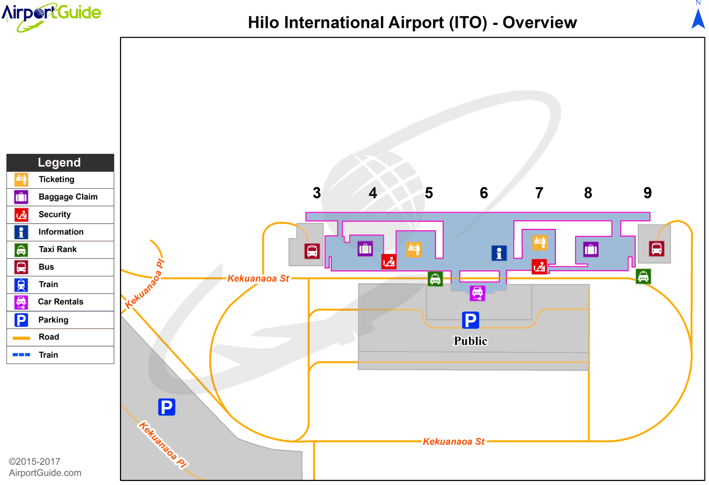
Maps & Diagrams
ITO Sectional
Flight Planning
at skyvector.com
at skyvector.com
 Diagram")